COMET is aiming to answer the following questions:
What is the distribution of tectonic strain and seismic hazard across the continents?
[read more=”Read more” less=”Read less”]
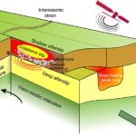
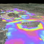
Maps of tectonic strain based on ground measurements are usually too simple for assessing seismic hazards. To help address this, we are developing techniques for measuring tectonic strain using InSAR data from the new Sentinel-1A satellite.
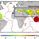
We are combining these measurements with ground-based observations to map tectonic strain throughout the Alpine-Himalayan Belt and East African Rift, identify active faults in these areas, and produce new models of seismic hazard.
[/read]
How does seismic hazard vary in space and time following major earthquakes?
[read more=”Read more” less=”Read less”]
The events in New Zealand in 2010 and 2011 are a powerful reminder of the unexpected nature of earthquakes and the hazard they can present: 182 people died in the Christchurch earthquake less than 6 months after an earthquake 40 km west of the city had no fatalities. Both earthquakes were on previously unknown faults.
But, if we have the right information on the location and magnitude of fault slip and background seismicity rates, we can estimate the continuing seismic hazard .
With the Sentinel-1 constellation, data is available within 3 days of an earthquake. We are using this to develop LiCSAR, our automated system for estimating fault locations and mechanisms for every continental earthquake above magnitude 6.0.
Near large population centres, we will also calculate stress changes on neighbouring faults so we can assess how the seismic hazard is changing.
[/read]
What is the structure of the continental lithosphere?
[read more=”Read more” less=”Read less”]
There are lots of things we still don’t know about continental deformation, such as:
- What controls the sizes and shapes of mountain ranges and sedimentary basins.
- What governs the location, magnitude, and style of active deformation.
- Whether long-term stresses are supported by the crust or the mantle.
- Why some continents deform whilst others are like rigid blocks.
- How our observations relate to the earthquake deformation cycle.
The answers depend on the 3D distribution of mechanical strength (rheology) in the continental lithosphere, but this in turn depends on the deformation of the Earth’s surface in space and time, which we know little about.
We will use Earth observation data to improve our knowledge and make progress in this area, impacting on a wide range of important issues from seismic hazard to natural resources.
[/read]
What are the patterns of volcanic deformation and degassing on global and regional scales, and how do these relate to the distribution of global volcanic hazard?
[read more=”Read more” less=”Read less”]
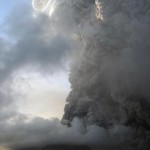
There are many different types of volcano: from persistently erupting to dormant, and from well-monitored to unexplored.
In the 16 least-developed countries with active volcanoes, over 100 million people live within 30 km of such a feature, less than 15% of which are monitored. Many are in remote or hostile environments.
Sentinel-1A is helping us to study this volcanic activity. We are using InSAR alongside Infrared Atmospheric Sounding Interferometry (IASI) to observe these volcanoes, and develop better measurements of volcanic degassing and deformation.
We will use this information to establish volcano monitoring services and, ultimately, an automated alert system. We will also study the signs of volcanic unrest and eruption, and combine them with ground measurements to improve models of volcanic activity.
[/read]
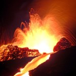
How does hazard vary in space and time during periods of volcanic activity?
[read more=”Read more” less=”Read less”]
Active volcanoes can change behaviour with little or no warning. During the 2010 eruption of Merapi in Indonesia, the initial lava was quickly followed by violent explosions and pyroclastic flows, resulting in the worst loss of life in a volcanic eruption for 20 years.
This means that we need to be better at recognising changes in volcanic activity, and what they might mean.
We are looking at this using both satellite and ground-based data. Because many volcanic processes are both sudden and short, we will be making particular use of new high-spatial resolution optical and radar imagery and short revisit-time satellites.
We will be studying active volcanoes in Montserrat, Ecuador, Colombia and Iceland, as well as others that erupt during the project lifetime.
[/read]
How do we model subsurface processes to better understand variations in volcanic behaviour?
[read more=”Read more” less=”Read less”]
To model volcanic processes in detail we need information on magma composition, gas emissions, conduit geometry and changes to the Earth’s crust. These can help us to both understand both a volcano’s internal state and predict its future behaviour.
Before we can develop these models, we need to know:
- What drives seismicity, deformation and gas release.
- What causes an eruption to change from effusive to explosive, or to stop.
- What the balance is between intrusive and extrusive magma fluxes in different tectonic settings.
- What governs periodicities and feedbacks in volcanic systems.
- How the properties of volcanic plumes relate to subsurface processes.
As we collect and understand the data, we are realising that many models of volcanic activity are too simple. We are already modelling dome-forming systems in more detail, and will continue to incorporate more information into our models.
[/read]