COMET has been awarded £950,000 by NERC to deliver cutting-edge research on earthquakes and volcanoes and to continue the development of hazard monitoring services.
NERC has officially announced the new funding for COMET on Wednesday 29 May. This will enable ambitious, large-scale science which helps us to understand global change and natural disasters over the next two years.
NERC National Capability lets the UK deliver world-leading environmental science, support national strategic needs, and respond to emergencies. It includes major research infrastructure and facilities, large-scale, long-term research programmes, and the provision of expert advice and services for public and national good.
You can read more about the award, and National Capability, on the NERC website.
Work led by COMET scientists Juliet Biggs and Andy Hooper is developing new methods for using artificial intelligence and satellite data monitor and potentially help predict volcanic eruptions.
Their work is described in a Nature article, published on 7 March 2019, which outlines how Juliet’s team at Bristol is using satellite imagery from the European Space Agency Sentinel-1 mission, alongside machine learning, to spot the formation of ground distortions around volcanoes.
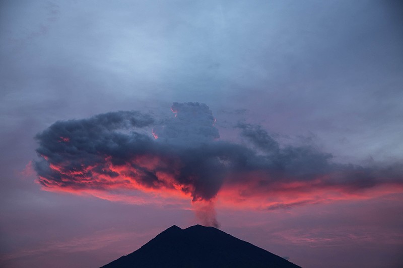
Agung volcano on the Indonesian island of Bali erupts in November 2017. Credit: Donal Husni/Zuma
Meanwhile at Leeds, Andy’s team is using a technique that searches for changes in the satellite data. Where the ground around a volcano is deforming, their method can flag if the distortion speeds up, slows down, or changes in some other way, allowing researchers to detect even small ground alterations.
The outstanding contributions of COMET UCL’s Professor Marek Ziebart to the science of space navigation, guidance and control have been recognised with a prestigious award from the US Institute of Navigation.
The Tycho Brahe Award is bestowed annually to an individual who has made a truly significant contribution to the science of spacecraft navigation and whose actions have benefited civilisation in any form.
Marek, who is Professor of Space Geodesy in the UCL Department of Civil, Environmental and Geomatic Engineering, focuses on the design of innovative navigation systems for spacecraft, including a navigation and communications system for manned and robotics missions to Mars and the moon between 2020 and 2040.
The US Institute of Navigation cited his outstanding innovation and leadership in the area of high precision, physics-based radiation force modelling for spacecraft orbit dynamics. His work has revolutionised the precision of satellite orbit modelling and led to a long running and successful collaboration with NASA Goddard Space Flight Center, where his methods have been applied to many NASA missions, including the Jason-1 satellite of the Ocean Surface Topography Mission to measure Earth’s sea levels.
Professor Ziebart said: “In receiving this award I’d like to acknowledge the help and support of my colleagues and the faculty at UCL. To me it seems that in this extraordinary institution you get smarter simply by osmosis. I feel privileged to be a part of UCL and working on research that is truly impactful and beneficial to the planet as a whole.”
The award was presented at a ceremony at the US Institute of Navigation in Washington on 31st January, 2019.
The achievements of four COMET scientists have been recognised in a recent spate of prizes!
Juliet Biggs, Reader at the University of Bristol, has been announced as a 2018 Philip Leverhulme Prize Winner, recognising her outstanding research in volcanology to date and future potential.
Juliet studies the physics by which plate boundaries develop by studying active volcanoes and earthquakes. Her work on Africa’s Great Rift Valley has demonstrated the relative role played by volcanoes, magma intrusions and faults during continental rifting.
Globally, she has discovered that many volcanoes previously believed to be dormant are actually restless, and investigated the link between deformation and eruption, and the mechanisms for coupled eruptions. Her work has changed the perception of geophysical hazards in Africa and the way in which volcanoes are monitored and modelled globally.
Juliet will use the prize to investigate the mechanisms that drive volcano deformation globally, by exploiting the new wealth of satellite data. This will include methods for combining satellite deformation and gas measurements to provide a new perspective on the role volatiles play in eruptions, and using deep learning tools to interrogate large datasets.
This award recognises her achievements in the field of volcanology as well as her ability to communicate with the public. Tamsin delivered the Rosalind Franklin Award Lecture on 18 October, speaking on how lessons learned sitting on the edge of an active volcano today can give us insights into some of the most profound environmental changes in geological history. With her award, Tamsin will now be implementing a project that raises the profile of women in STEM.
This is given every two years in recognition for “original contributions to the basic knowledge of crust and lithosphere.” Professor England will be awarded his medal at the AGU Fall Meeting later this year.
Finally, our congratulations go to the 2019 Thermo-Fisher Scientific VMSG awardee, Dr Marie Edmonds, Reader in Earth Sciences at the University of Cambridge.
This award is bestowed annually on an individual who has made a significant contribution to our current understanding of volcanic and magmatic processes, and Marie will give the VMSG keynote lecture in January 2019.
The timing and size of three deadly earthquakes that struck Italy in 2016 may have been pre-determined, according to new research published in Earth and Planetary Science Letters that could improve future earthquake forecasts.
Credit: L.Gregory
A joint British-Italian team of geologists and seismologists have shown that the clustering of the three quakes might have been caused by the arrangement of a cross-cutting network of underground faults.
The findings show that although all three earthquakes occurred on the same major fault, several smaller faults prevented a single massive earthquake from occurring instead and also acted as pathways for naturally occurring fluids that triggered later earthquakes.
The cluster of three earthquakes, termed a “seismic sequence” by seismologists, each had magnitudes greater than six and killed more than 300 people in Italy’s Apennine mountains between 24 August and 30 October 2016.
Earthquake sequences
The research, led by COMET scientist Richard Walters from Durham University, comes on the second anniversary of the start of the earthquake sequence.
The researchers say the findings could have wider implications for the study of seismic hazards, enabling scientists to better understand potential earthquake sequences following a quake.
Dr Walters said: “These results address a long-standing mystery in earthquake science – why a major fault system sometimes fails in a single large earthquake that ruptures its entire length, versus failing in multiple smaller earthquakes drawn-out over months or years.
“Our results imply that even though we couldn’t have predicted when the earthquake sequence would start, once it got going, both the size and timing of the major earthquakes may have been pre-determined by the arrangement of faults at depth.
“This is all information we could hypothetically know before the event, and therefore, this could be a hugely important avenue for improving future earthquake forecasts.”
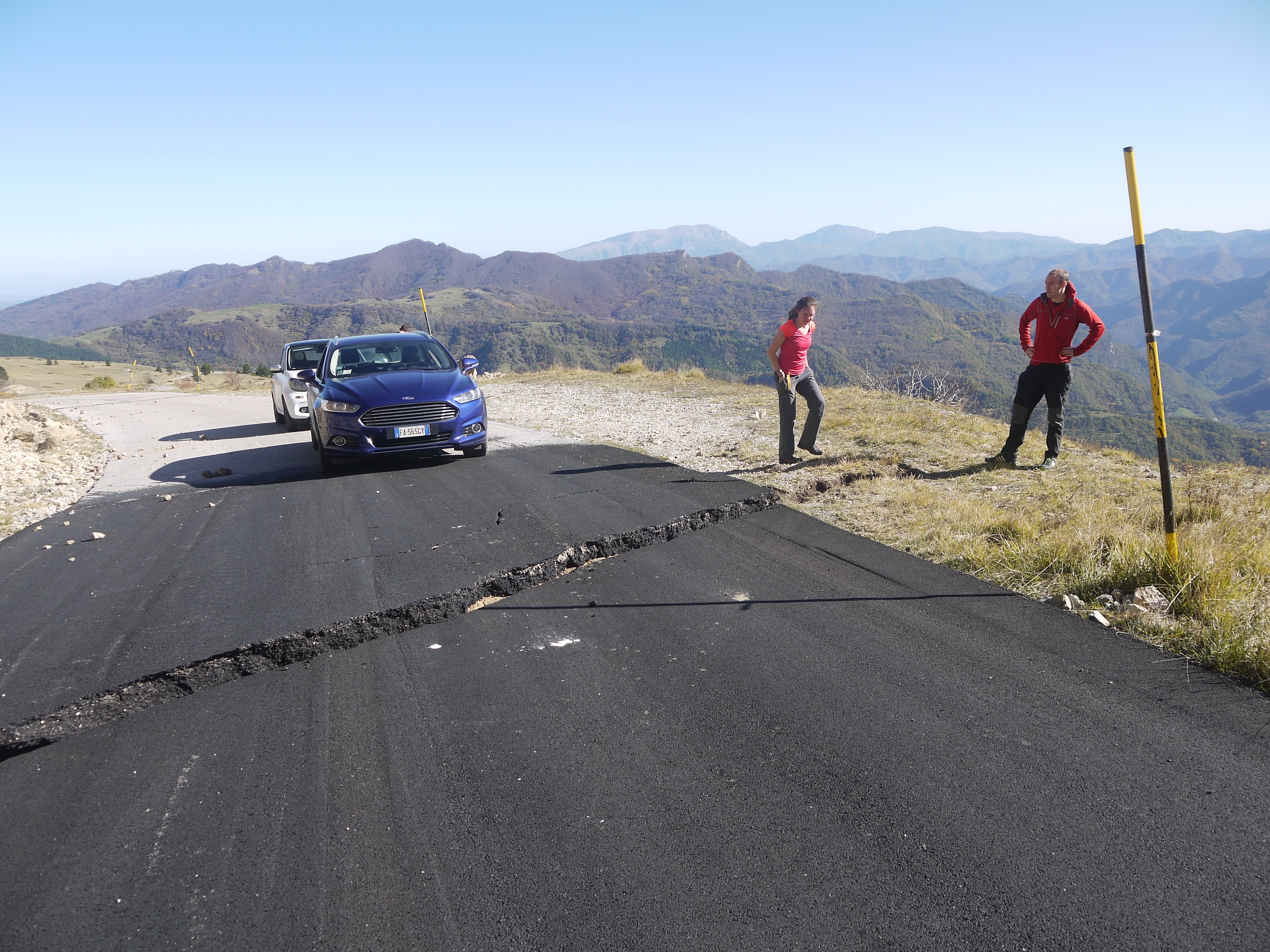
Location of survey site at rupture across a road near Castelluccio. The rupture occurred during the third earthquake in the seismic sequence and gives researchers a record of the deformation. Credit: L.Gregory
Thousands of aftershocks
Dr Walters and the team used satellite data to estimate which part of the fault failed in each earthquake, and compared this pattern with the location and timing of thousands of tiny aftershocks throughout the seismic sequence.
They found that intersections of small faults with the main fault system separated each of the three largest earthquakes, strongly suggesting these intersections stop the growth of each earthquake and prevent the faults failing in a single large event.
In addition, the scientists also found that after the first earthquake, thousands of aftershocks crept northwards along these same fault intersections at a rate of around 100 metres per day, in a manner consistent with naturally occurring water and gas being pumped along the faults by the first earthquake on 24 August, 2016.
The second earthquake, on the 26 October, occurred exactly when these fluids reached its location, therefore controlling the relative timing of failure.
Dr Walters added: “It was a big surprise that these relatively small faults were having such a huge influence over the whole sequence.
“They stop the first earthquake in its tracks, and then they channel the fluids that start the sequence up again months later. No-one’s ever seen this before.”
Seismic hazard
Co-author and COMET associate Dr Laura Gregory from the University of Leeds said it was important to understand whether or not a fault fails in a seismic sequence, and that the team’s results were only made possible by combining a varied array of different datasets.
Dr Gregory said: “A seismic sequence has vastly different implications for seismic hazard compared to a single large earthquake. If the faults in Italy in 2016 had failed together in one big event, the impact on the local population would have been much worse.
“This is the first time we’ve ever had this quality of modern data over one of these earthquake sequences, and bringing together a range of specialists was key for unpicking how the earthquakes related to one another.
“I was scrambling over the mountainside immediately after each earthquake with British and Italian colleagues, measuring the metre-high cliffs that had suddenly formed. Meanwhile, other members of our team were analysing data from seismometers stationed around the world, or were mapping the tiny bending of the ground around the faults using satellites orbiting the planet at 500 miles altitude.”
The research was partly supported by both COMET and a NERC Urgency Grant.
The award is made to an individual for an outstanding contribution to any area of Science, Technology, Engineering and Mathematics (STEM) and to support the promotion of women in STEM.
Tamsin will receive a silver gilt medal at her Award Lecture in October 2018. Congratulations Tamsin from all of your COMET colleagues.
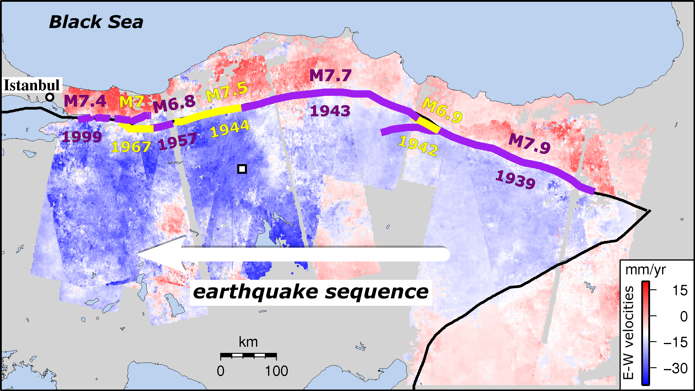
Satellite data has shed new light on seismic hazard in one of the world’s most deadly earthquake zones.
Published today in Nature Communications, the COMET study describes how tectonic strain builds up along Turkey’s North Anatolian Fault at a remarkably steady rate.
This means that present-day measurements can not only reflect past and future strain accumulation, but also provide vital information on events still to come.
The strain, which builds up as Turkey is squeezed between three major tectonic plates, has caused almost the entire length of the fault to rupture since 1939 in a series of major earthquakes gradually migrating east-west towards Istanbul.
Strain rates along Turkey’s North Anatolian Fault (past ruptures shown in purple/yellow) alongside westward progression of earthquakes since 1939
Led by COMET PhD student Ekbal Hussain[1], the team used satellite images from the European Space Agency’s Envisat mission to identify tiny ground movements at earthquake locations along the fault.
Dr Hussain explained: “Because we know so much about the fault’s recent history, we could look at the strain build up at specific places knowing how much time had passed since the last earthquake.”
The 600-plus satellite images, taken between 2002 and 2010, provided insights into the equivalent of 250 years of the fault’s earthquake repeat cycle.
Remarkably, apart from the ten years immediately after an earthquake, strain rates levelled out at about 0.5 microstrain per year, equivalent to 50mm over a 100km region, regardless of where or when the last earthquake took place.
Dr Hussain added: “This means that the strain rates we measure over the short term can also reflect what’s happening in the longer term, telling us how much energy is being stored on the fault and could eventually be released in an earthquake.”
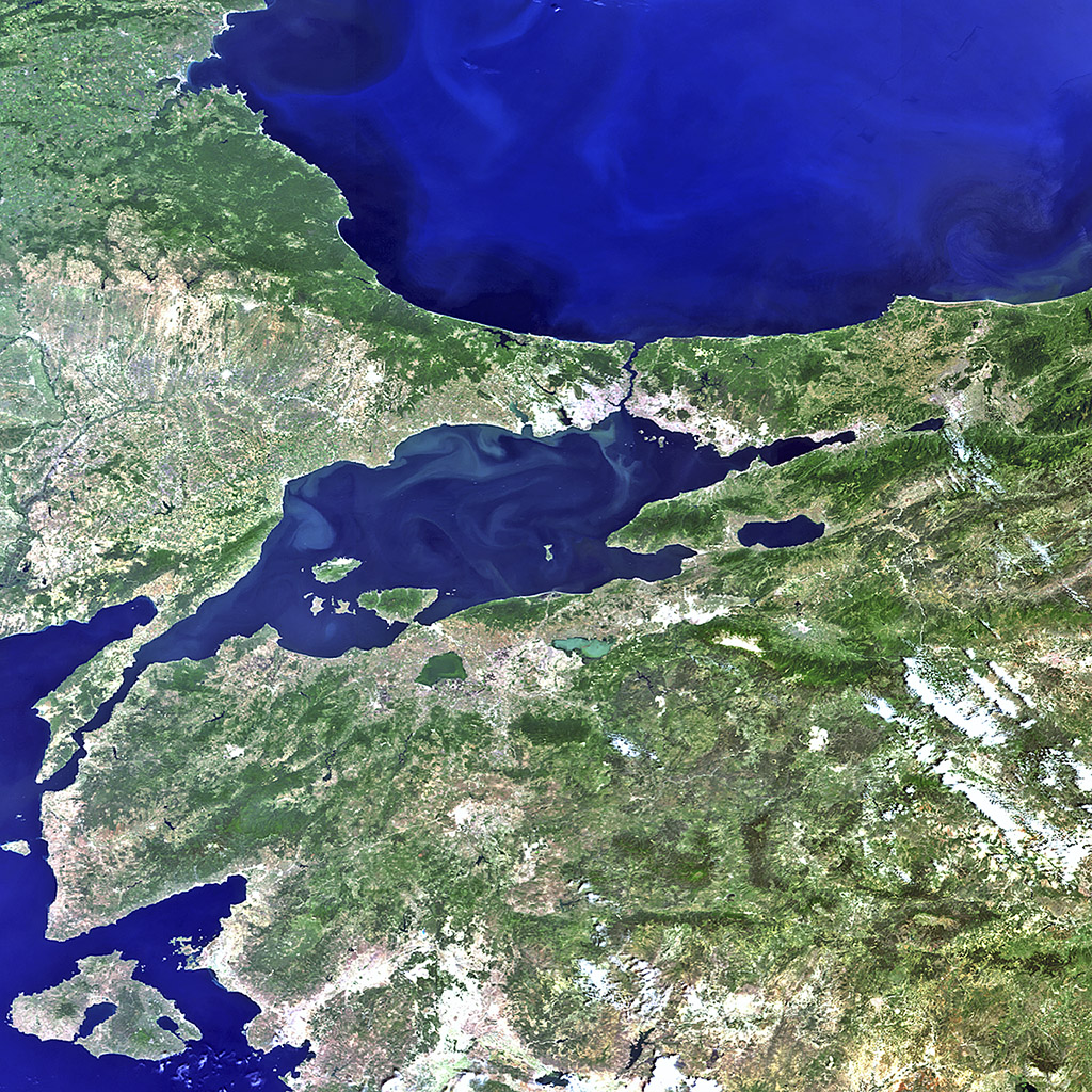
Istanbul, straddling the Bosphorus Strait at the centre of the picture, and the surrounding area in northwestern Turkey captured by Envisat. Turkey’s location makes it vulnerable to earthquakes, with the North Anatolian fault lying just 15 km south of Istanbul. Credit: ESA
Until the satellite era, it was difficult to get a clear picture of how strain built up on the fault. Now, satellites like Envisat, alongside the newer Sentinel-1 mission, can detect ground movements of less than a millimetre, indicating how and where strain is accumulating.
The findings suggest that some existing hazard assessment models, which presume that strain rates vary over time, need to be rethought. This is especially true for regions where there are long gaps between earthquakes, such as the Himalayas.
Co-author and COMET Director Tim Wright said: “Discovering this consistent strain accumulation will help us to reassess how we model seismic hazards, as well as improving understanding of the earthquake cycle worldwide.”
The full paper is: Hussain et al. (2018) Constant strain accumulation rate between major earthquakes on the North Anatolian Fault, Nature Communications, doi:10.1038/s41467-018-03739-2
[1] Now Remote Sensing Scientist at BGS Keyworth. Dr Hussain is available for comment (ekhuss@bgs.ac.uk).
COMET’s achievements in Earth observation and modelling have been recognised by the Royal Astronomical Society (RAS) in their latest round of awards.
The 2018 RAS Group Achievement Award in Geophysics acknowledges COMET’s success in using satellite and ground-based observations and geophysical modelling to study earthquakes, volcanoes and tectonics across the globe.
COMET Director Tim Wright said: “We are delighted that our collective achievements have been recognised by the RAS in this way. It’s particularly rewarding to receive an honour for the full breadth and depth of COMET’s research.”
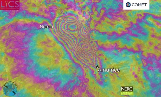
In granting the award, the RAS highlighted COMET’s contributions to satellite geodesy, particularly Synthetic Aperture Radar Interferometry (InSAR), which has significantly improved COMET’s ability to respond to tectonic events. Notably, COMET’s InSAR capabilities allowed rapid and in-depth investigations into the 2016 Amatrice, Italy and Kaikoura, New Zealand earthquakes.
Sentinel-1 interferogram of the ground deformation around Amatrice, Italy due to the 24 August 2016 earthquake.
Professor Wright added: “In both cases, we used InSAR to reveal the surprising complexity of the underlying faults, helping us to interpret the events and improve seismic hazard models.”
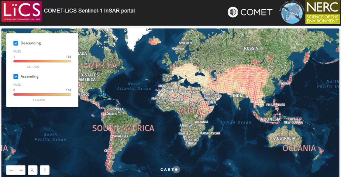
The launch of LiCSAR, COMET’s automated processing system, in December 2016 represented a major forward step in managing the vast amounts of data generated by the Sentinel-1 constellation, part of the EU’s Copernicus programme. LiCSAR is enabling scientists to study specific earthquakes and eruptions as well as longer-term records of tectonic strain and ground deformation around volcanoes – including potential signs of eruption.
The service is already providing high-resolution deformation data for the entire Alpine-Himalayan seismic belt, where most of the planet’s deadly earthquakes occur, and will be expanded to provide global coverage of the tectonic belts over the next few years.
LiCSAR, the COMET-LiCS Sentinel-1 InSAR portal
COMET is also using automated Sentinel-1 data alongside other techniques to monitor deformation at over 900 volcanoes worldwide, including regions with hazardous volcanoes that have no ground-based monitoring in place. The ultimate goal is to monitor all active land volcanoes, around 1,300 in total.
Elsewhere in COMET, satellite imagery is being combined with topographic data and fieldwork to create a database of active faults in the Tien Shan, a region of high seismic hazard in northern Central Asia. Working with international partners, this is creating a robust regional model of strain accumulation and release that can be used in hazard management.
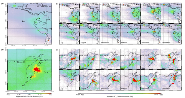
Atmospheric studies are also central to COMET’s work. The satellite-borne Infrared Atmospheric Sounding Instrument (IASI) is being used to monitor volcanic ash and SO2 emissions such as those from Holuhraun (Iceland), whose eruption in 2014-15 was a major source of SO2 emissions. Holuhraun’s remoteness made it difficult to monitor the volcano from the ground, especially during the harsh Icelandic winter, but using IASI data, COMET was able to provide insights into both the volcano’s behaviour and its environmental impacts. The same approach has now been extended to other remote volcanoes such as Kamchatka (Russia) and Tungurahua (Ecuador).
Elevated levels of SO2 frequently identified using IASI measurements at volcanoes in Ecuador (a,b) and Kamchatka, Russia (c,d)
These are just a few aspects of COMET’s work, carried out by researchers across the UK as part of national and international collaborations. At the same time, COMET is supporting a vibrant community of around 80 research students, working on topics ranging from monitoring volcano deformation to modelling earthquake sequences. There is a strong commitment to developing the next generation of researchers, with COMET providing bespoke training to both members and the wider community on interpreting InSAR and GPS data to better understand geohazards and achieve scientific goals.
Moving forward, COMET remains committed to providing open data on earthquakes, tectonics and volcanoes to support scientists worldwide, and providing greater insight into how the Earth is deforming.
Professor Wright summarised: “This honour from RAS is a great reward for the efforts being made across the COMET family to improve our understanding of earthquakes and volcanoes. The aim now is to continue to make ground-breaking progress that also benefits the communities and decision makers managing these geohazards as part of daily life.”
Notes
The NERC-funded UK Centre for Observation and Modelling of Earthquakes, Volcanoes and Tectonics (COMET) provides national capability in the observation and modelling of tectonic and volcanic hazards. COMET delivers services, facilities, data and long-term research to produce world-leading science that can help the UK and others to prepare for, and respond rapidly to, earthquakes and eruptions. Further information can be found at https://comet.nerc.ac.uk.
COMET was founded in 2002, rapidly becoming a world-leading centre for the integrated exploitation of Earth Observation and ground-based data with geophysical models for research into geohazards. From 2008 to 2014, COMET formed a theme within the National Centre for Earth Observation (NCEO). Since 2014, COMET has worked in partnership with the British Geological Survey (BGS).
COMET is currently distributed across nine UK academic institutions: the universities of Bristol, Cambridge, Durham, Leeds, Liverpool, Newcastle, Oxford and Reading and University College London. A full membership list can be found at https://comet.nerc.ac.uk/whos-who/.
The Royal Astronomical Society (ras.org.uk) was founded in 1820 to encourage and promote the study of geophysics as well as astronomy and solar-system science. The Group Award recognises outstanding achievement by large consortia in any branch of astronomy or geophysics. The full citation for COMET’s award can be found via the RAS website.
LiCSAR, the COMET-LiCS Sentinel-1 InSAR portal can be found at https://comet.nerc.ac.uk/COMET-LiCS-portal. LiCSAR is funded by NERC via COMET (COME30001), the Looking inside the Continents from Space large grant (NE/K011006/1), and the Earthquakes without Frontiers project (NE/J01978X/1).
As part of the RiftVolc consortium, COMET researchers David Pyle, Tamsin Mather and Juliet Biggs have co-authored a new paper on geothermal monitoring and volcanic hazard at Aluto volcano in the Ethiopian Rift Valley.
COMET scientist Juliet Biggs will receive the 2017 Geodesy Section Award at this year’s American Geophysical Union (AGU) Fall Meeting, to be held 11–15 December in New Orleans.The award recognises Juliet’s outstanding contributions to the field of satellite geodesy for understanding both active volcanism and faulting.
On receiving the award, she said: “Many of the previous AGU Geodesy Section Award winners have been role models for me personally, and seeing my name among them is truly humbling.”
You can read the full article on the AGU’s Eos website.


 The award recognises Juliet’s outstanding contributions to the field of satellite geodesy for understanding both active volcanism and faulting.