In November 2023, a state of emergency was suddenly declared in a fishing town in Iceland, Grindavík, and all residents were rapidly evacuated. In the space of around 6 hours, escalating seismic activity was felt: large cracks and fault movements occurred at the earth’s surface, and homes, businesses and infrastructure were destroyed.
This devastation was caused by huge amounts of magma moving at an unprecedented speed below the surface, which rushed into a crack that opened up below the town. The intrusion that formed was approximately 15-kilometres-long and extended around 1-5 km deep, with widening of up to 8 meters.
The processes and timescales behind the formation of major cracks, or “dikes”, aren’t currently fully understood but the international team of researchers behind a paper published in Science today have revealed new findings that shed some light on how these hazardous events occur.
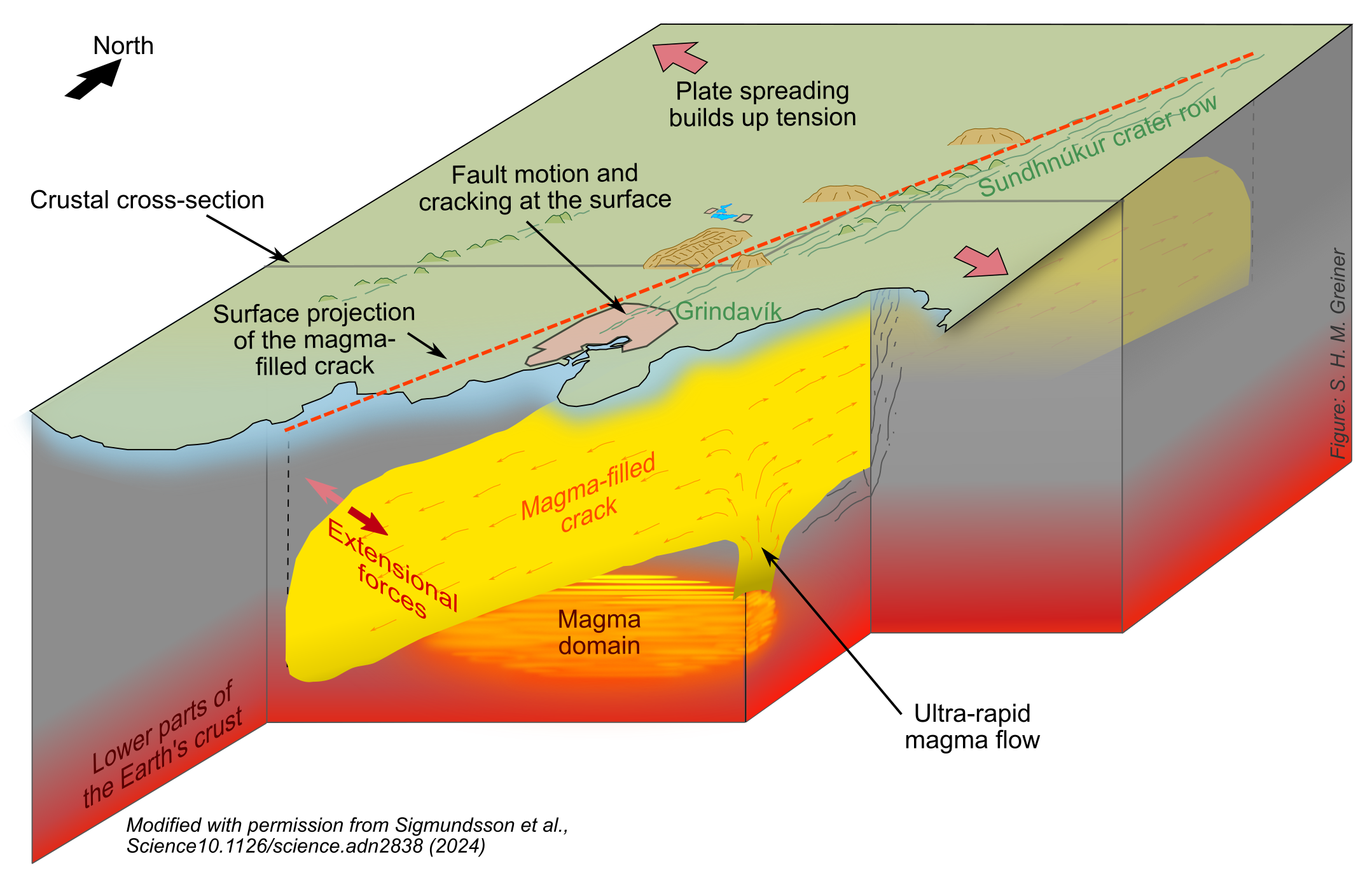
Using detailed satellite observations alongside seismic measurements and physical modelling, the team of investigators led by University of Iceland and the Icelandic Meteorological Office, found that the magma flow rate under the surface of the earth reached an ultra-rapid and previously unrecorded speed of 7400 cubic meters per second. The study also shows that huge amounts of magma can be forced into cracks due to fracturing in the earth and tectonic stress, without much pressure coming from underlying magma source that feeds it. These findings demonstrate a significant hazard potential for this volcanic system and others with similar features, which can result in large-volume magmatic eruptions on the surface.
COMET Scientist, Professor Andy Hooper, was a key member of the team of investigators:
“Nothing like these rates of magma flow have ever been measured before. Luckily, the magma did not make it to the surface at that time, but this helps us understand how magma-filled cracks that are tens of kilometres long may have formed in the past.”
The events in November were the beginning of the activity in the affected area around Grindavík. Smaller magma intrusions occurred in December 2023 and January 2024, which unfortunately culminated in large eruptions and further devastation in the town, and a new, ongoing eruption started this morning (February 8th 2024).
Publication available here (open access for all for two weeks): https://www.science.org/doi/10.1126/science.adn2838