COMET scientists used the Sentinel-1A satellite to map ground movements associated with an ongoing volcanic eruption in the remote island of Fogo, Cape Verde.
An eruption from Pico do Fogo volcano, which makes up the island of Fogo (Cape Verde), began inside the Cha das Caldera in the morning of 23 November, after increased seismic activity in the previous weeks. About 700 people were evacuated from Chã das Caldeiras and the local airport was closed.
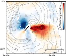
COMET scientists based at the University of Leeds, in collaboration with colleagues from PPO labs and Norut, processed data from the European Space Agency’s Sentinel-1A satellite to measure the ground deformation signals associated with the eruption. Two satellite radar images were combined to produce an image of the ground deformation between 3 and 27 November:

Ground deformation caused by magma intrusion within the volcano, measured by Sentinel-1A, is shown above. The surface ground deformation indicates that the eruption is fed by a magma-dyke running in a south-westerly direction from the centre of the caldera.
The deformation pattern indicates that a sheet-like body of magma moved upwards from a depth of many kilometres, reaching the surface and leading to the eruption.
This unwrapped interferogram shows a preliminary model of the displacements recorded with Sentinel-1A radar data suggest that a dyke with an estimated volume of around 0.01 km^3 of magma (equivalent to 4000 Olympic swimming pools)was intruded, which is currently feeding the volcanic eruption. The lack of wide-island deformation anomalies indicates that the magma is likely arriving from sources located deep under the island (depths of more than 10-15 km).

