Observations of Deformation
| Volcano number: | 313010 |
|---|---|
| Region: | Alaska |
| Country: | United States |
| Geodetic measurements? | Yes |
| Deformation observation? | Yes |
| Measurement method(s): | InSAR, GPS - continuous, GPS - campaign, EDM |
| Duration of observation: | 1989, early 1990s - 2009 |
| Inferred cause(s) of deformation: | Magmatic, Surface deposits |
| Characteristics of deformation: |
EDM measurements at Augustine began in 1986, with campaign GPS surveys conducted in the early 1990s and 2000, and 5 continuous GPS stations established in 2004 by PBO. Campaign GPS data suggest subsidence between 1988 and 2000 of <5 mm/yr, consistent with deflation of a source < a few km beneath the volcano summit. The continuous GPS network then suggest uplift of 2 mm/month between June 2005 to January 2006 resulting from a shallow source. SBAS InSAR measurements between 1992 and 2005 also indicate steady, wholescale uplift of the volcano by 2–8 cm. This pre-eruptive deformation is modelled using two Mogi sources beneath the summit area. The shallower source (1.7 – 3.8 km depth) contracted at a rate of 0.2 x 10^6 m³/yr, whereas the deeper source (7–12 km depth) inflated at a rate of 2 x 10^6 m³/yr. InSAR observations also reveal subsidence of the 1986 pyroclastic flows on the north flank of Augustine. Finite element models of this subsidence indicate an initial excess temperature for the pyroclastic flow deposit of 640 °C and an average thickness of 9.3 m.
InSAR observations covering the 2005 – 2006 eruption reveal horizontal displacements of up to 20 mm, which is in agreement with continuous GPS measurements. Post-eruption InSAR observations show post-eruption contraction of 2006 and 1986 eruptive products, but no volcano-wide deformation pattern.
|
| Reference(s): | Pauk, B. A., Jackson, M., Feaux, K., Mencin, D., & Bohnenstiehl, K. (2010). The Plate Boundary Observatory permanent Global Posi- tioning System network on Augustine Volcano before and after the 2006 eruption. In J. A. Power, M. L. Coombs, & J. T. Freymueller (Eds.), The 2006 eruption of Augustine Volcano, Alaska (pp. 467–477). U.S. Geological Survey Professional Paper 1769. |
| Cervelli, P., Fournier, T., Freymueller, J., & Power, J. A. (2006). Ground deformation associated with the precursory unrest and early phases of the January 2006 eruption of Augustine Volcano, Alaska. Geophysical Research Letters,33, L18304. doi:10.1029/ 2006GL027219. | |
| Lee, C.-W., Lu, Z., Jung, H.-S., Won, J.-S., & Dzurisin, D. (2010a). Surface deformation of Augustine Volcano, 1992–2005, from multiple-interferogram processing using a refined small baseline subset (SBAS) interferometric synthetic aperture radar (InSAR) approach, chapter 18. In J. Power, M. L. Coombs, & J. T. Freymueller (Eds.) The 2006 Eruption of Augustine Volcano, Alaska (pp. 453–465). U.S. Geological Survey Professional Paper 1769. Retrieved from http://pubs.usgs.gov/pp/1769/chapters/ p1769_chapter18.pdf | |
| Lu, Z., and Dzurisin, D., 2014, InSAR imaging of Aleutian volcanoes: Chichester, UK, Springer-Praxis, 390 p. | |
| U.S. Geological Survey Alaska Volcano Observatory (AVO) website http://www.avo.alaska.edu/volcanoes/volcinfo.php?volcname=Augustine | |
| Location: | 59.363, -153.43 |
| REST API endpoint (JSON): | https://comet.nerc.ac.uk/wp-json/volcanodb/v1/volcano/726 |
Latest Sentinel-1 Data
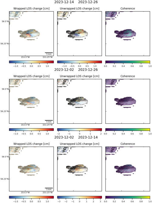
Size: 501px x 669px (75.38 KB)
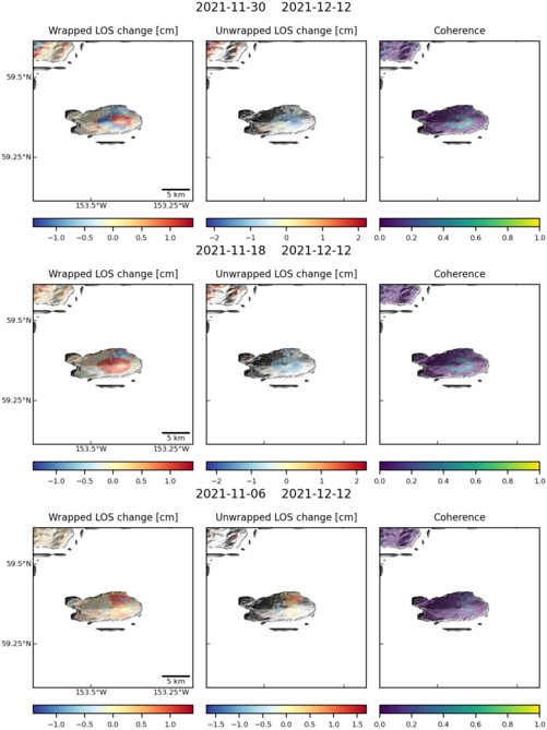
Size: 501px x 669px (74.70 KB)