
Observations of Deformation
| Volcano number: | 341000 |
|---|---|
| Region: | Mexico and Central America |
| Country: | Mexico |
| Geodetic measurements? | Yes |
| Deformation observation? | Yes |
| Measurement method(s): | InSAR, Levelling |
| Duration of observation: | 1994-2006 (levelling), 1993-1997 (ERS InSAR), 2003-2006 (Envisat InSAR) |
| Inferred cause(s) of deformation: | Hydrothermal |
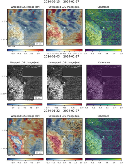
| Characteristics of deformation: | Between 1993 and 1997, ERS InSAR data showed that the Cerro Prieto Geothermal Field was subsiding at up to 6 cm year-1 (Carnec and Fabriol 1999). |
| Reference(s): | Carnec C, Fabriol H, 1999. Monitoring and modeling land subsidence at the Cerro Prieto geothermal field, Baja California, Mexico, using SAR interferometry. Geophysical Research Letters, 26: 1211-1214. |
| Sarychikhina, O. E. Glowacka, R. Mellors and F. Suárez Vidal, 2011. Land subsidence in the Cerro Prieto Geothermal Field, Baja California, Mexico, from 1994 to 2005: An integrated analysis of DInSAR, leveling and geological data. J. Volcanol. Geotherm. Res., 204 (2011) 76-90. | |
| Location: | 32.418, 115.305 |
| REST API endpoint (JSON): | https://comet.nerc.ac.uk/wp-json/volcanodb/v1/volcano/4434 |
Latest Sentinel-1 Data

Size: 501px x 660px (167.35 KB)
Size: 501px x 666px (151.31 KB)