Observations of Deformation
| Volcano number: | 311020 |
|---|---|
| Region: | Alaska |
| Country: | United States |
| Geodetic measurements? | Yes |
| Deformation observation? | Yes |
| Measurement method(s): | InSAR |
| Duration of observation: | 1995 - 2009 |
| Inferred cause(s) of deformation: | Hydrothermal |
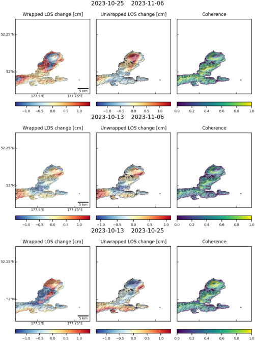
| Characteristics of deformation: | Between 1999 – 2000, Kiska volcano subsided by up to 7 cm (volume decrease 0.00003 km³). Interferograms spanning 2000 – 2001 suggest that subsidence continued but at a lower rate (maxmimum displacements ~2 cm). During 2004 – 2005, no deformation occured, but in 2005 – 2006 the summit area of the volcano uplifted by 3 – 4 cm (volume increase 0.00001 km³). The volcano then again subsided between 2006 – 2008 by ~3 cm (volume decrease 0.000005 km³). Overall these observations suggest that during times of quiescence, Kiska alternately uplifts and subsided, with a subsidence prevailing in the long term. |
| Reference(s): | Lu Z., Masterlark, T., Power, J., Dzurisin, D., & Wicks, C. (2002c), Subsidence at Kiska volcano, western Aleutians, detected by satellite radar interferometry. Geophysical Research Letters, 29, doi:10.1029/2002GL014948. |
| Lu, Z., and Dzurisin, D., 2014, InSAR imaging of Aleutian volcanoes: Chichester, UK, Springer-Praxis, 390 p. | |
| U.S. Geological Survey Alaska Volcano Observatory (AVO) website http://www.avo.alaska.edu/volcanoes/volcinfo.php?volcname=Kiska | |
| Location: | 52.103, 177.602 |
| REST API endpoint (JSON): | https://comet.nerc.ac.uk/wp-json/volcanodb/v1/volcano/1057 |
Latest Sentinel-1 Data
Size: 501px x 669px (82.04 KB)