Observations of Deformation
| Volcano number: | 223020 |
|---|---|
| Region: | Africa and Red Sea |
| Country: | DR Congo |
| Geodetic measurements? | Yes |
| Deformation observation? | Yes |
| Measurement method(s): | InSAR |
| Duration of observation: | 2002 - 2012 |
| Inferred cause(s) of deformation: | Magmatic, Surface deposits |
| Characteristics of deformation: | Nyamuragira is a broad, highly active, shield volcano, that has been the focus of some InSAR studies. A long list of eruption dates can be found on the Smithsonian GVP website, most of which are flank eruptions. During the January 2010 11 cm eastward co-eruptive displacement to the east of the volcano was observed. Samsonov and d’Oreye (2012) describe deformation at several points around the volcano at several different times, and, if the reader is interested, they are directed there for more detail and clarification on locations.
|
| Reference(s): | Smithsonian Institution Global Volcanism Program http://www.volcano.si.edu/volcano.cfm?vn=211010 |
| Samsonov, S., & d'Oreye, N. (2012). Multidimensional time-series analysis of ground deformation from multiple InSAR data sets applied to Virunga Volcanic Province. Geophysical Journal International, 191(3), 1095-1108. | |
| Toombs, A., & Wadge, G. (2012). Co-eruptive and inter-eruptive surface deformation measured by satellite radar interferometry at Nyamuragira volcano, DR Congo, 1996 to 2010. Journal of Volcanology and Geothermal Research, 245, 98-122. | |
| Location: | -1.408, 29.2 |
| REST API endpoint (JSON): | https://comet.nerc.ac.uk/wp-json/volcanodb/v1/volcano/5296 |
Latest Sentinel-1 Data
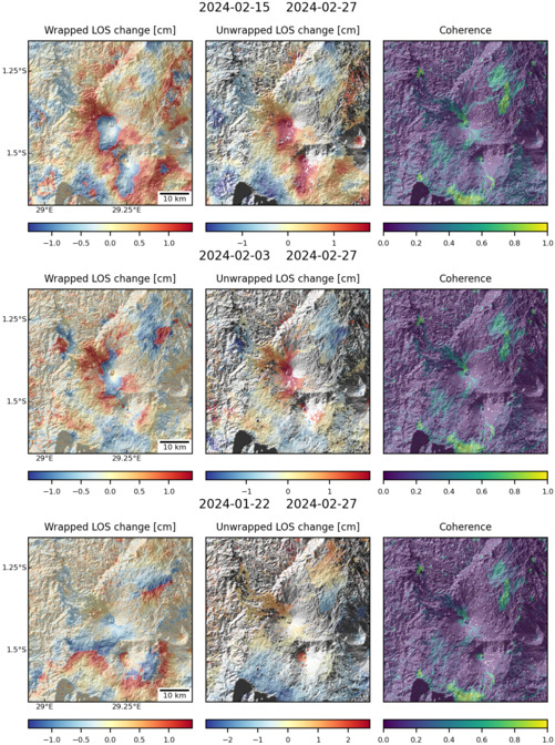
Size: 501px x 672px (182.54 KB)
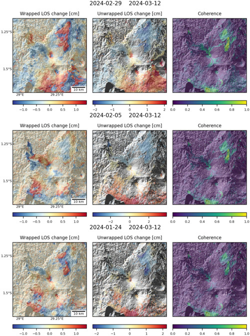
Size: 501px x 672px (181.70 KB)