Observations of Deformation
| Volcano number: | 313040 |
|---|---|
| Region: | Alaska |
| Country: | United States |
| Geodetic measurements? | Yes |
| Deformation observation? | Yes |
| Measurement method(s): | InSAR |
| Duration of observation: | 1993 - 2010 |
| Inferred cause(s) of deformation: | Magmatic |
| Characteristics of deformation: | InSAR measurements at Spurr cover two seismic swarms. The first swarm took place in 1996 – 1998 at Strandline Lake, 30 km northeast of Spurr. Initial InSAR observations showed no evidence of strong surface deformation, ruling out magma intrusion at depths <10 km (Kilgore et al., 2011). Later observations by Lu and Dzurisin (2014) identify broad inflation associated with this event, and find that best-fitting models agree with a deep source (12-16 km). InSAR measurements covering a second earthquake swarm in 2004 – 2005 beneath the summit of Spurr also show broad inflation at 10 – 14 km depth. Modelled volume changes associated with both events are similar (0.04 – 0.06 km³), and are interpreted to be caused by episodic intrusion of magma into the crust. InSAR measurements outside of these periods show no evidence of deformation. |
| Reference(s): | Kilgore, W.W., Roman, D.C., Biggs, Juliet, and Hansen, Roger, 2011, Seismic and geodetic investigation of the 1996-1998 earthquake swarm at Strandline Lake, Alaska: Geophysical Journal International, v. 186, n. 3, p. 1365-1379, doi:10.1111/j.1365-246X.2011.05115.x. |
| Lu, Z., and Dzurisin, D., 2014, InSAR imaging of Aleutian volcanoes: Chichester, UK, Springer-Praxis, 390 p. | |
| U.S. Geological Survey Alaska Volcano Observatory (AVO) website http://www.avo.alaska.edu/volcanoes/volcinfo.php?volcname=Spurr | |
| Location: | 61.299, -152.251 |
| REST API endpoint (JSON): | https://comet.nerc.ac.uk/wp-json/volcanodb/v1/volcano/5201 |
Latest Sentinel-1 Data
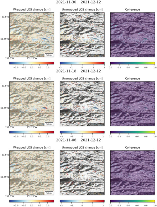
Size: 501px x 660px (166.60 KB)
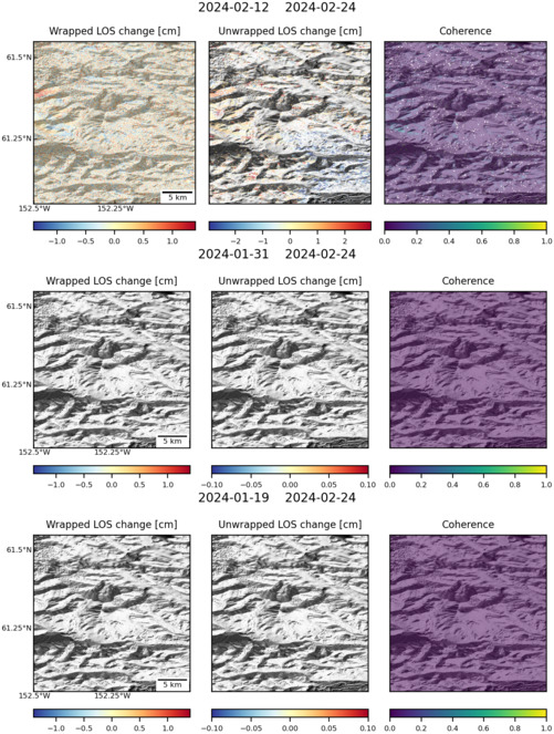
Size: 501px x 663px (148.18 KB)