Observations of Deformation
| Volcano number: | 211050 |
|---|---|
| Region: | Mediterranean and W. Asia |
| Country: | Italy |
| Geodetic measurements? | Yes |
| Deformation observation? | Yes |
| Measurement method(s): | InSAR, Levelling, EDM, trilateration |
| Duration of observation: | 1978 to 1998, 2008 to 2013 (present) |
| Inferred cause(s) of deformation: | Surface deposits, Faulting/tectonics |
| Characteristics of deformation: | Continuous GPS monitoring of Lipari and Vulcano islands started in April 1995, when a four-site permanent GPS network (VVLC, VCSP, LOSV and VGPL) was installed by the International Institute of Volcanology, now Istituto Nazionale di Geofisica e Vulcanologia (INGV-CT; Mattia et al., 2008). |
| Reference(s): | Solaro, G., Castaldo, R., Casu, F., De Luca, C., Marsella, M., Pepe, A., ... & Zeni, G. (2014, May). Insights Into The Dynamics Of Aeolian Volcanic Islands From DInSAR COSMO-SkyMed Observations. In EGU General Assembly Conference Abstracts (Vol. 16, p. 6689). |
| Bonaccorso, A. (2002). Ground deformation of the southern sector of the Aeolian islands volcanic arc from geodetic data. Tectonophysics, 351(3), 181-192. | |
| Smithsonian Institution Global Volcanism Program http://www.volcano.si.edu/volcano.cfm?vn=211050 | |
| Regional and country profiles of volcanic hazard and risk. Report IV of the GVM/IAVCEI contribution to the Global Assessment Report on Disaster Risk Reduction 2015 S.K. Brown, R.S.J. Sparks, K. Mee, C. Vye-Brown, E. Ilyinskaya, S. Jenkins, S.C. Loughlin http://www.preventionweb.net/english/hyogo/gar/2015/en/bgdocs/risk-section/GVMd.%20Global%20Volcanic%20Hazards%20and%20Risk%20Country%20volcanic%20hazard%20and%20risk%20profiles..pdf | |
| Mattia, M., Palano, M., Bruno, V., Cannavò, F., Bonaccorso, A., & Gresta, S. (2008). Tectonic features of the Lipari–Vulcano complex (Aeolian archipelago, Italy) from 10 years (1996–2006) of GPS data. Terra Nova, 20(5), 370-377. | |
| Location: | 38.404, 14.962 |
| REST API endpoint (JSON): | https://comet.nerc.ac.uk/wp-json/volcanodb/v1/volcano/1846 |
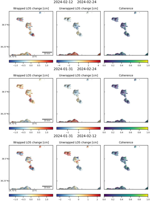
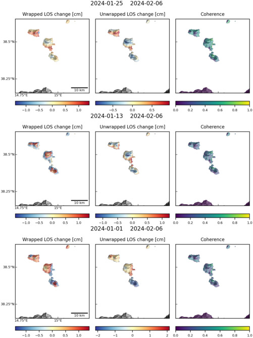
Latest Sentinel-1 Data

Size: 501px x 669px (66.29 KB)
Size: 501px x 669px (67.21 KB)

Size: 750px x 1110px (106.80 KB)
Size: 501px x 669px (66.70 KB)