
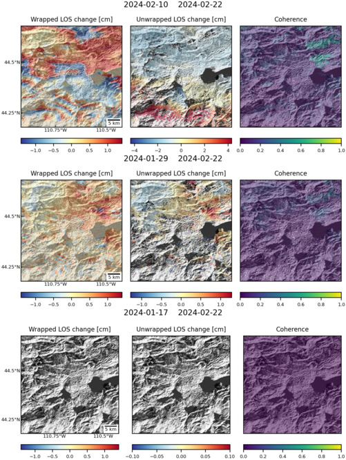
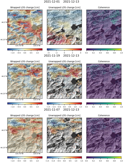
Observations of Deformation
| Volcano number: | 325010 |
|---|---|
| Region: | Canada and Western USA |
| Country: | United States |
| Geodetic measurements? | Yes |
| Deformation observation? | Yes |
| Measurement method(s): | InSAR, GPS - continuous, GPS - campaign, Levelling, Strainmeter, Gravity |
| Duration of observation: | 1923 - present |
| Inferred cause(s) of deformation: | Hydrothermal, Magmatic |
| Characteristics of deformation: | Between 1923 – 1985, ~60 cm of uplift was measured at Yellowstone, including ~18 cm of ground deformation measured by leveling between 1976 – 1984. This was followed by a shorter period of subsidence (1985 – 1992) with displacements of ~14 cm. Up until this time it was thought that all ground deformation occurred all in the central part of the Yellowstone caldera. However, between 1997 – 2003, 12-13 cm of uplift occurred in a different region measuring ~35 x 40 km centered on the northern caldera rim. Outside of this region subsidence of up to 4 cm was recorded. Since this time, ground deformation has refturned to the central part of the caldera. Between 2004 – 2006, GPS and InSAR data show that Yellowstone uplifted by up to 7 cm/yr, with total displacements of 17 cm. Models of this deformation episode infer magma intruded ~10 km beneath the caldera. This magma input is thought to have fractured the crust, releasing hydrothermal fluids and resulting in subsidence of the region to the north, which had previously uplifted. Further analysis of GPS data between 2004 – 2010 reveal horizontal extension of up to 0.7 cm beneath Yellowstone lake. Using evidence from borehole strainmeters, it is estimated that magma is present 3 – 6 km beneath the surface of Yellowstone and that the magma is partially molten. |
| Reference(s): | U.S. Geological Survey Yellowstone Volcano Observatory https://volcanoes.usgs.gov/volcanoes/yellowstone/monitoring_map.html |
| Dzurisin, D., Yamashita, K. M., & Kleinman, J. W. (1994). Mechanisms of crustal uplift and subsidence at the Yellowstone caldera, Wyoming. Bulletin of Volcanology, 56(4), 261-270. | |
| Wicks, C., Thatcher, W., & Dzurisin, D. (1998). Migration of fluids beneath Yellowstone caldera inferred from satellite radar interferometry. Science, 282(5388), 458-462. | |
| Wicks, C., Thatcher, W., Dzurisin, D. & Svarc, J. (2006). Uplift, thermal unrest and magma intrusion at Yellowstone caldera. Nature , 440, p 72-75. doi:10.1038/nature04507 | |
| Chang, W., Smith, R. B., Farrell, J. & Puskas, C. M. (2010). An extraordinary episode of Yellowstone caldera uplift, 2004–2010, from GPS and InSAR observations. Journal of Geophysical Research , 37, 6 pp. doi:10.1029/2010GL045451 http://www.agu.org/pubs/crossref/2010/2010GL045451.shtml | |
| Location: | 44.43, -110.67 |
| REST API endpoint (JSON): | https://comet.nerc.ac.uk/wp-json/volcanodb/v1/volcano/1227 |
Latest Sentinel-1 Data
Size: 501px x 666px (167.34 KB)
Size: 501px x 660px (170.82 KB)