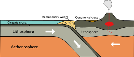
When one tectonic plate subducts or dives beneath another, an accretionary wedge is a pile of sediments which forms above the fault line where these two plates meet. This sediment pile forms when the plate on top scrapes sediments from the subducting plate. Sometimes there are thrust faults within the accretionary wedge (such as in the below diagram) that can slip during earthquakes:
An active fault is a fault that has slipped (had movement on it) recently and therefore may slip again in the future. This slip may result in an earthquake. There is no fixed amount of geological time to define how recent a fault must have moved to be considered active as different fault settings have different rates of movement.
Aftershocks are earthquakes that occur in the same general area in the following days to years after a larger event or ‘mainshock’. These earthquakes have a smaller magnitude than this mainshock but can be just as devastating. Aftershocks must be within 1-2 fault lengths distance from the mainshock and occur before the background seismicity rate has resumed.
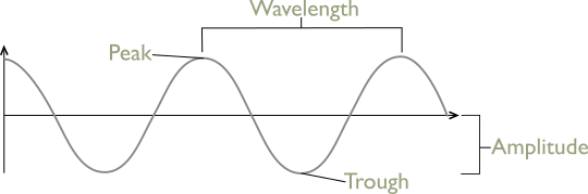
The amplitude of a seismic wave is the maximum displacement up or down of the wave/ground surface. Amplitude can be measured as half the distance between the crest and the trough of the wave.
Aseismic motion or creep occurs when there is measurable displacement or deformation at the surface along a fault, but no earthquakes ruptured during the displacement. Aseismic motion often happens on faults with low friction.
An asperity if an area of a fault with high friction that is locked and preventing the fault from slipping. During an earthquake, most of the energy is released when these areas slip.
Attenuation is the decrease in size (amplitude) of seismic waves as they move away from the earthquake where they were released. Waves decrease in size or ‘attenuate’ as they lose energy the further they travel.
Bedrock is the solid rock that sits beneath loose surface sediments (e.g. sand, clay, soil). This bedrock forms the uppermost part of the Earth’s crust and is what is able to rupture during an earthquake.
A blind thrust fault is a fault which shows no signs or evidence at the surface of existing underneath the ground. These faults can be very destructive, remaining unmapped for many years. People may build their homes on top of these hidden faults without taking any precautions for earthquakes. The thrusting motion of these faults may develop rolling hills and valleys.
Body waves are a type of seismic wave that travel through the central parts of the Earth. The other broad type of seismic wave is surface waves, which travel, in contrast to body waves, along the surface of the Earth. Body waves include primary (P) waves and secondary (S) waves.
Coulomb stress is a measure of the combination of shear and normal stresses acting on a fault. This stress measure changes over time, particularly if there are earthquakes nearby. If the Coulomb failure stress increases after a nearby earthquake, the fault is now more likely to rupture in an earthquake. If the Coulomb failure stress decreases, the likelihood of an earthquake on this fault is lower.
Creep occurs on moving faults when energy is released slower than during an earthquake. Creep can occur at a continuous rate on a fault or occur in several creep events. Recent work by scientists has shown that creep can still pose a significant hazard, despite not releasing as much energy as suddenly as earthquakes.
The outermost solid (rigid) layer of the Earth. The crust is the top part of the lithosphere, the layer of the Earth which moves as tectonic plates. There are two main types of crust: oceanic and continental crust. Not only are these two crust types found in different locations but are composed of different types of rocks and minerals!
The change in shape of the Earth’s crust, the ground surface, or any other material.
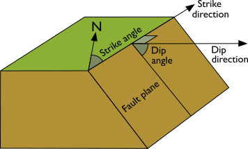
The angle of the fault plane relative to a flat surface above the fault plane. This angle is measured perpendicular to the strike of the plane (see below diagram).
When a fault ruptures, the seismic waves are often focused along the fault in the direction the fault has ruptured. This action is called directivity. Directivity causes strong shaking due to an earthquake to be located in an elongated pattern along the site of the fault, meaning damage to buildings is often localised to the fault location.
The visible offset of the ground across a fault following an earthquake, creep event or period of creep.
An earthquake is the sudden shaking or trembling of the Earth's surface caused by the rapid release of energy in the Earth's crust. This energy release usually occurs when stress that has built up over time along a fault line is suddenly released, causing the ground to break or slip.
Earthquake intensity measures the effects and severity of an earthquake at specific locations on the Earth's surface. It reflects the degree of shaking and damage experienced at various places, rather than the earthquake's overall size or energy release.
Measurement Scales:
Earthquake recurrence refers to the pattern or frequency with which earthquakes occur on a particular fault or in a specific region over time. It is an estimate of how often earthquakes of a certain magnitude are expected to happen in each area based on historical data and geological evidence.
An earthquake rupture is the extent of slip that happens during an earthquake.
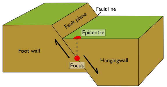
The point on the Earth's surface that is directly above the earthquake's focus or hypocentre. The focus or hypocentre is the actual location on the fault at depth within the Earth where the earthquake originates, and seismic energy is released.
A volcanic eruption is a geological event where magma, gases, and ash are expelled from a volcano or a volcanic vent. This occurs when the pressure of gases and molten rock inside the Earth's crust exceeds the strength of the surrounding rock, allowing these materials to escape to the surface.
Types of Volcanic Eruptions:
Earthquakes typically occur along faults, which are fractures in the Earth's crust where two blocks of rock have moved past each other. When the stress on the fault exceeds the friction on the fault, the fault breaks and slips, resulting in an earthquake.
The main parts of a fault are:
The main types of faults are:
A fault in which the slip direction is the same as the dip direction. This type of fault includes normal faults, reverse faults, and thrust faults:
Movement on a fault. Sometimes this movement can cause a break in the Earth’s surface called a surface rupture. Most movement on a fault, or fault rupture, occurs due to an earthquake.
A small step feature in the landscape caused by an earthquake. At this step, the two blocks either side of the fault have moved and offset.
A fault may not be one, long, continuous line in space. Instead, a fault may be divided or segmented into many smaller sections which slip in slightly different orientations and at differing rates. This is fault segmentation.
At the Earth’s surface, a visible sign of a fault meeting the surface. A fault trace differs to a fault line in that a fault line may not be visible at the surface.
The depth at which an earthquake occurs i.e. the depth of the earthquake focus.
Any action that either changes the speed of movement of an object or causes the object to change shape.
Foreshocks are earthquakes which rupture before the main earthquake event or ‘mainshock’. These earthquakes are smaller magnitude than this mainshock and cannot be identified as foreshocks until after the mainshock and following aftershocks.
In terms of waves, frequency is the number of waves that produced by a source, such as an earthquake, every second. We measure frequency in hertz (Hz), which is another way of saying ‘waves per second’.
The hypocentre (or focus) of an earthquake is the point within the Earth on a fault where the earthquake originates. It is the location where the strain energy stored in the Earth's crust is first released, leading to the generation of seismic waves that propagate outward and cause the shaking associated with an earthquake.
Synthetic Aperture Radar Interferometry (InSAR) is a remote sensing technique that relies on radar satellites that return to the same area every few days, sending radar waves down to the ground surface and measuring the energy that is reflected back.
InSAR uses two or more satellite radar images acquired over the same area to map topography and detect surface changes. Small changes on the ground cause changes in the radar signal phase and lead to the rainbow-coloured fringes of an ‘interferogram’.
By creating images from the data (interferograms) and analysing the patterns, we can measure differences in the time it takes the waves to make the round trip from the satellite to the Earth and back.
If part of the ground has moved further away from the satellite, perhaps because of an earthquake or volcanic eruption, the waves take slightly longer to return to the satellite. We can measure these differences in every pixel of the radar image to give us a map of how the ground has moved to within a few millimetres.
InSAR can also help us to understand where and when future disasters might happen. For example, before volcanoes erupt, magma often rises into a shallow reservoir beneath the volcano surface, causing it to lift up. If we detect magma movement, we can alert local decision makers and scientists to the potential hazard.
Meanwhile, although predicting earthquakes is near-impossible, the ground surface around faults slowly changes in response to tectonic forces. We can also use InSAR to measure how the surface is changing, and to assess earthquake risk.
InSAR is particularly important in remote areas and developing countries because it does not rely on having expensive instruments on the ground. Even in places like California and Japan where there are extensive instrument networks, no other technique can give us measurements with InSAR’s level of detail, covering such large areas.
We can also use the radar to identify areas that have been damaged, providing vital information for emergency response teams.
Magma is molten rock that is found beneath the Earth's surface. It is composed of a mixture of minerals, gases, and sometimes small amounts of crystals and dissolved volatiles, such as water vapor, carbon dioxide, and sulphur dioxide.
Multispectral data refers to information collected across multiple specific wavelength bands of the electromagnetic spectrum. Unlike single-band (or monochromatic) data, which captures information in just one part of the spectrum, multispectral data captures information in several distinct bands, each corresponding to a different range of wavelengths.
Wavelength Bands:
Multispectral data is collected across several predetermined bands, which can include visible light, near infrared, and shortwave infrared. Each band captures different spectral information that can be used to identify various materials and features.
Examples of Bands:
Paleoseismology is the study of ancient earthquakes and the geological evidence they leave behind. It focuses on identifying and analysing past seismic activity by examining features in the Earth's crust, such as faults, sediment layers, and disrupted landforms. The goal of paleoseismology is to understand the history of earthquakes in a specific area, including their frequency, magnitude, and effects over thousands to millions of years.
Plate tectonics is a scientific theory that describes the large-scale motion of the Earth's lithosphere, which is divided into several rigid plates that float on the semi-fluid asthenosphere beneath them. The lithospheric plates are in constant motion, and their interactions at plate boundaries give rise to various geological phenomena such as earthquakes, volcanic activity, mountain formation, and the creation of ocean basins.
The theory of plate tectonics explains how these plates move, interact, and undergo processes like subduction, where one plate is forced beneath another, and seafloor spreading, where new oceanic crust is formed. The interactions between these plates are driven by heat from the Earth's interior, primarily from the radioactive decay of elements, creating convection currents in the mantle that move the plates.
Plate tectonics is a unifying concept in geology that provides a comprehensive framework for understanding the dynamic nature of the Earth's surface and the geological features and events that occur over geological time scales.
Probabilistic Seismic Hazard Analysis (PSHA) is a methodology used in seismology to assess the likelihood of different levels of ground shaking at a specific location over a given period. This analysis incorporates a range of uncertainties associated with seismic activity to estimate the probability of earthquakes of varying magnitudes and distances from the site of interest. Some of the key components are:
By integrating these elements, PSHA provides a comprehensive and quantitative evaluation of seismic hazard, which is valuable for seismic design, engineering, and risk assessment for structures and infrastructure in earthquake-prone regions.
Remote sensing is the technique of collecting and analysing information about an object or area from a distance, typically without direct physical contact. This method is commonly used to observe and gather data about the Earth's surface, atmosphere, and various environmental and man-made features.
Types of Remote Sensing:
Sensors and Platforms:
Data Types:
Applications:
The release of energy during an earthquake generates seismic waves that travel through the Earth. These waves cause the shaking felt during an earthquake. There are different types of seismic waves, including:
Fault slip rate refers to the average rate at which two sides of a fault move relative to each other over time. It is a measure of how quickly the rocks on either side of the fault are slipping past one another, usually expressed in millimetres or centimetres per year.
The deformation or change in shape of a material (such as rock) specifically in response to applied stress (pressure). While stress is the force per unit area exerted on a rock, strain describes how that rock physically responds to the stress.
There are three main types of strain:
In geology, stress refers to the force per unit area exerted on a material, such as rock, within the Earth's crust. This stress is generally as a result of tectonic or volcanic forces generated by the movement of tectonic plates and other geological processes. Stress can cause deformation in rocks, leading to various geological phenomena, including faulting, folding, and the formation of mountains.
There are three main types of geologic stresses:

The 2024/2025 COMET Annual Report is now available to view online
Click here to read previous annual reports, from 2014-present.