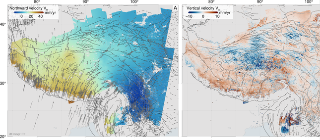

On 25 April, a 7.8-magnitude earthquake struck Nepal, claiming over 8,000 lives and affecting millions of people.
Images from ESA’s Sentinel-1A satellite clearly showed the effects of the earthquake, including the maximum land deformation only 17km from Nepal’s capital, Kathmandu. This explains the extremely high damage to the area.

By combining Sentinel-1A imagery from before and after the quake, COMET scientists have been able to interpret the rainbow-coloured interference patterns in the image (known as an interferogram), and interpret them as changes on the ground. COMET scientists have also been analysing the 12 May aftershock. You can read more here.

The 2024/2025 COMET Annual Report is now available to view online
Click here to read previous annual reports, from 2014-present.