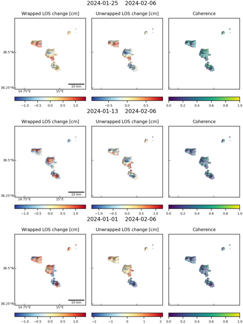
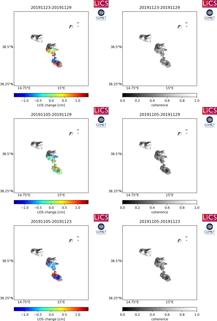
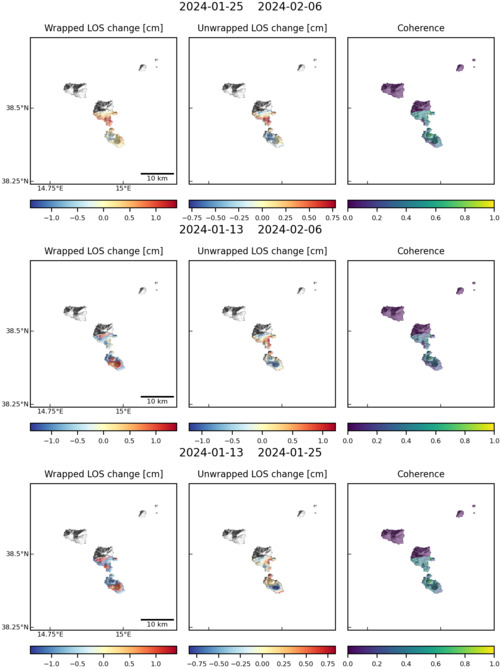
Observations of Deformation
| Volcano number: | 211042 |
|---|---|
| Region: | Mediterranean and W. Asia |
| Country: | Italy |
| Geodetic measurements? | Yes |
| Deformation observation? | Yes |
| Measurement method(s): | InSAR, GPS - continuous, GPS - campaign |
| Duration of observation: | 1996 to 2006 (present) |
| Inferred cause(s) of deformation: | Surface deposits, Faulting/tectonics |
| Characteristics of deformation: | Continuous GPS monitoring of Lipari and Vulcano islands started in April 1995, when a four-site permanent GPS network (VVLC, VCSP, LOSV and VGPL) was installed by the International Institute of Volcanology, now Istituto Nazionale di Geofisica e Vulcanologia (INGV-CT; Mattia et al., 2008). The Instituto Nazionale di Geofisica e Vulcanologia (INGV) monitors active volcanoes in Italy via multiparametric systems. In particular, the INGV Observatories Vesuviano and Etneo are responsible for the surveillance of the Campi Flegrei, Vesuvius, Ischia, Etna, Stromboli, Panarea, Lipari, Vulcano and Pantelleria volcanoes (Brown et al., 2008).
|
| Reference(s): | Smithsonian Institution Global Volcanism Program http://www.volcano.si.edu/volcano.cfm?vn=211042 |
| Mattia, M., Palano, M., Bruno, V., Cannavò, F., Bonaccorso, A., & Gresta, S. (2008). Tectonic features of the Lipari–Vulcano complex (Aeolian archipelago, Italy) from 10 years (1996–2006) of GPS data. Terra Nova, 20(5), 370-377. | |
| Regional and country profiles of volcanic hazard and risk. Report IV of the GVM/IAVCEI contribution to the Global Assessment Report on Disaster Risk Reduction 2015 S.K. Brown, R.S.J. Sparks, K. Mee, C. Vye-Brown, E. Ilyinskaya, S. Jenkins, S.C. Loughlin http://www.preventionweb.net/english/hyogo/gar/2015/en/bgdocs/risk-section/GVMd.%20Global%20Volcanic%20Hazards%20and%20Risk%20Country%20volcanic%20hazard%20and%20risk%20profiles..pdf | |
| Solaro, G., Castaldo, R., Casu, F., De Luca, C., Marsella, M., Pepe, A., ... & Zeni, G. (2014, May). Insights Into The Dynamics Of Aeolian Volcanic Islands From DInSAR COSMO-SkyMed Observations. In EGU General Assembly Conference Abstracts (Vol. 16, p. 6689). | |
| Bonaccorso, A. (2002). Ground deformation of the southern sector of the Aeolian islands volcanic arc from geodetic data. Tectonophysics, 351(3), 181-192. | |
| Location: | 38.48, 14.95 |
| REST API endpoint (JSON): | https://comet.nerc.ac.uk/wp-json/volcanodb/v1/volcano/5269 |
Latest Sentinel-1 Data
Size: 501px x 669px (62.87 KB)
Size: 750px x 1110px (98.29 KB)
Size: 501px x 669px (63.34 KB)

Size: 501px x 669px (63.01 KB)