A Decade Of Sentinel-1 Research
02-04-2026

COMET researchers have used the European Space Agency’s Sentinel-1A satellite to shed light on the 2014-15 eruption at Fogo, the most active volcano in the Cape Verde archipelago.
Their paper, published in Geophysical Research Letters, investigates the eruption using Sentinel-1A’s new radar acquisition mode, Terrain Observation by Progressive Scans (TOPS).
Fogo has erupted at least 26 times in the last 500 years, and this particular event lasted 81 days from November 2014 to February 2015. It had devastating consequences for the island. Fast lava flows destroyed the villages of Portela and Bangaeria in early December 2014.
As the satellite had only been operating for a few weeks when the eruption began, this is the first study to use Sentinel-1A TOPS to investigate surface deformation associated with volcanic activity.
Lead author Dr Pablo J. González, from the University of Leeds, explained: “the study has given us a real insight into the inner workings of Fogo volcano. It also shows the potential of Sentinel-1’s TOPS mode for monitoring volcanic activity in the future acheter du viagra.”
Up until recently, the volcano had mostly been monitored by a GPS network with limited spatial coverage. In comparison, the wide area and high spatial resolution of Sentinel-1A’s satellite images allowed the team, which included researchers from Norway, The Netherlands and Canada, to monitor ground deformation across Fogo.
Using the TOPS data, they found that during the eruption the ground surface had changed in a “butterfly” shape, characteristic for a dike intrusion (where the magma intrudes into a fissure, shouldering aside other the existing layers of rock).
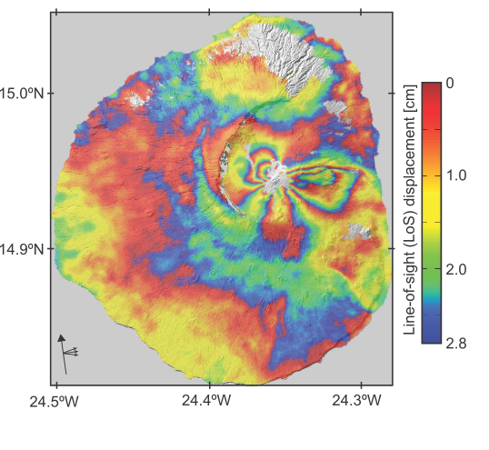
Models created to reproduce the observed data then showed that first of all the magma moved rapidly from depths of more than ten kilometres below the volcano’s summit. It then moved along the dike to feed the eruption at a fissure on the southwestern flank of the volcano’s summit cone, rather than from its top.
This was backed up by the satellite data showing a lack of deformation across the whole island during the eruption, which would have suggested that it was instead being fed by an inflating/deflating magma reservoir directly beneath.
The findings will now set the direction for further research aimed at understanding the pattern of eruptions on the island, as well as assessing the stability of the entire volcanic structure.
Dr Marco Bagnardi, COMET researcher, and also co-author in this paper, added: “Our results not only show the importance of near-real time ground deformation monitoring at Fogo, they also demonstrate the potential of Sentinel-1A’s TOPS mode for monitoring geohazards more widely.”
The full paper, The 2014-2015 eruption of Fogo volcano: geodetic modelling of Sentinel-1 TOPS interferometry, is available now in Geophysical Research Letters

The 2024/2025 COMET Annual Report is now available to view online
Click here to read previous annual reports, from 2014-present.