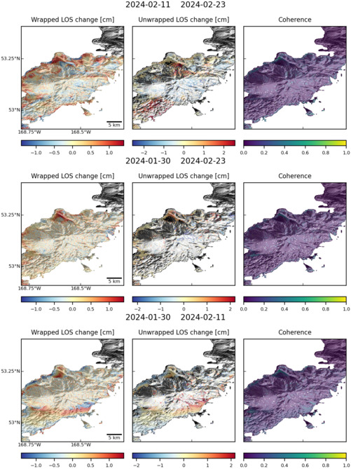
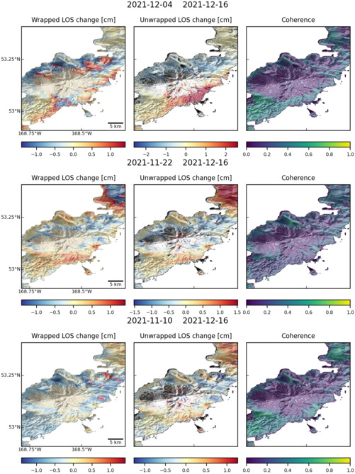
Observations of Deformation
| Volcano number: | 311280 |
|---|---|
| Region: | Alaska |
| Country: | United States |
| Geodetic measurements? | Yes |
| Deformation observation? | Yes |
| Measurement method(s): | InSAR |
| Duration of observation: | 2003 - 2010 |
| Inferred cause(s) of deformation: | Hydrothermal, Magmatic, Faulting/tectonics |
| Characteristics of deformation: | Interferograms show a broad areas of uplift on the northeastern flank of Recheshnoi with peak rates of ~1 cm/yr. Superimposed upon this is a localised subsidence signal of up to 0.5 cm/yr. Uplift is modelled as a sill (horizontal disloaction) at 4 – 6 km depth and is thought to be caused by an influx of magma. The subsidence signals sharply bounded and are thought to be due to a small graben sturcture reactivated by subsidence of nearby hydrothermal features Geyser Bight and Hot Springs Cove. |
| Reference(s): | Lu, Z., and Dzurisin, D., 2014, InSAR imaging of Aleutian volcanoes: Chichester, UK, Springer-Praxis, 390 p. |
| U.S. Geological Survey Alaska Volcano Observatory (AVO) website http://www.avo.alaska.edu/volcanoes/volcinfo.php?volcname=Recheshnoi | |
| Location: | 53.157, -168.539 |
| REST API endpoint (JSON): | https://comet.nerc.ac.uk/wp-json/volcanodb/v1/volcano/985 |
Latest Sentinel-1 Data
Size: 501px x 669px (130.80 KB)
Size: 501px x 669px (130.92 KB)