Observations of Deformation
| Volcano number: | 213040 |
|---|---|
| Region: | Mediterranean and W. Asia |
| Country: | Turkey |
| Geodetic measurements? | Yes |
| Deformation observation? | Yes |
| Measurement method(s): | InSAR |
| Duration of observation: | 2003 to 2010 |
| Inferred cause(s) of deformation: | Magmatic, Surface deposits, Faulting/tectonics, Uncertain |
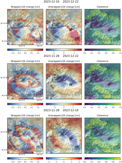
| Characteristics of deformation: | The Turkish National Commission for Volcanology and Chemistry of the Earth’s Interior and Hacettepe University undertake some monitoring in Turkey. Three volcanoes have records of historic activity – Nemrut Dagi, Ararat (Agri Dagi) and Tendürek Dagi. Of these, only Nemrut Dagi, has three seismometers dedicated to the monitoring of the volcano (Brown et al., 2015). No specific details about volcano deformation at Ararat are presented in Bathke et al. (2011). The authors state “The InSAR data shows various localized but evident deformation processes related to volcano flank motion, summit subsidence as well as shallow earthquake activity.” |
| Reference(s): | Bathke, H., and T. R. Walter (2011) Volcano and earthquake deformation at Ararat and Tendurek, eastern Turkey, shown by InSAR time series (abstract EGU2011-2242), EGU General Assembly. |
| Regional and country profiles of volcanic hazard and risk. Report IV of the GVM/IAVCEI contribution to the Global Assessment Report on Disaster Risk Reduction 2015 S.K. Brown, R.S.J. Sparks, K. Mee, C. Vye-Brown, E. Ilyinskaya, S. Jenkins, S.C. Loughlin http://www.preventionweb.net/english/hyogo/gar/2015/en/bgdocs/risk-section/GVMd.%20Global%20Volcanic%20Hazards%20and%20Risk%20Country%20volcanic%20hazard%20and%20risk%20profiles..pdf | |
| Smithsonian Institution Global Volcanism Program http://www.volcano.si.edu/volcano.cfm?vn=213040 | |
| Location: | 39.7, 44.3 |
| REST API endpoint (JSON): | https://comet.nerc.ac.uk/wp-json/volcanodb/v1/volcano/1726 |
Latest Sentinel-1 Data
Size: 501px x 669px (171.07 KB)

Size: 501px x 669px (167.68 KB)