Observations of Deformation
| Volcano number: | 341040 |
|---|---|
| Region: | Mexico and Central America |
| Country: | Mexico |
| Geodetic measurements? | Yes |
| Deformation observation? | Yes |
| Measurement method(s): | InSAR, GPS - continuous, GPS - campaign, Levelling, Tiltmeter, EDM, Pixel offsets from thermal infrared imagery |
| Duration of observation: | 1982-1999 (levelling), 1982-present (tiltmeters), 1994-present (GPS), 1996-2000, 2004-present (EDM), 2002-2007 (ENVISAT InSAR), 2007-2010 (ALOS InSAR), 2011-2013 (TSX InSAR), 2011 (Thermal IR) |
| Inferred cause(s) of deformation: | Magmatic, Surface deposits |
| Characteristics of deformation: | The first deformation measurements of Colima were made with annual levelling surveys, and were complemented with GPS stations installed in the mid 1990’s (Murray & Wooler, 2002). They recorded a persistent subsidence at a rate of 5 mm/year, 1.1 km from the summit (levelling), and 93 mm/yr at the edge of the dome (GPS). The GPS also recorded horizontal displacements at a maximum rate of 23 mm/year near the dome. Simple deformation models were unable to fit the observations, and the deformation was thought to most likely be due to a combination of downslope creep, settling and compaction of the edifice, and gravitational spreading (Murray & Wooler, 2002). |
| Reference(s): | J.B. Murray, L.K. Wooller (2002), Persistent summit subsidence at Volcan de Colima, Mexico, 1982–1999: strong evidence against Mogi deflation. J. Volcanol. Geotherm. Res., 117, pp. 69–78, doi:10.1016/S0377-0273(02)00236-6 |
| J.J. Ramı́rez Ruiz, H. Santiago-Jimenez, E. Alatorre-Chavez, M. Bretón-Gonzalez (2002), EDM deformation monitoring of the 1997–2000 eruption at Volcán de Colima. J. Volcanol. Geotherm. Res., 117, pp. 61–67, doi:10.1016/S0377-0273(02)00235-4 | |
| V.M. Zobin, J.J. Ramírez, H. Santiago, E. Alatorre, C. Navarro (2010), Relationship between tilt changes and effusive–explosive episodes at an andesitic volcano: the 2004–2005 eruption at Volcán de Colima, México. Bull. Volcanol. (2010) http://dx.doi.org/10.1007/s00445-010-0405-4 | |
| Walter, T. R., D. Legrand, H. D. Granados, G. Reyes, and R. Arámbula (2013), Volcanic eruption monitoring by thermal image correlation: Pixel offsets show episodic dome growth of the Colima volcano, J. Geophys. Res. Solid Earth, 118, 1408–1419, doi:10.1002/jgrb.50066. | |
| .T. Salzer, M. Nikkhoo, T.R. Walter, H. Sudhaus, G. Reyes-Dávila, M. Bretón, R. Arambula (2014), Satellite radar data reveal short-term pre-explosive displacements and a complex conduit system at Volcan de Colima, Mexico, Front. Earth Sci., 2, http://dx.doi.org/10.3389/feart.2014.00012 | |
| Location: | 19.514, -103.62 |
| REST API endpoint (JSON): | https://comet.nerc.ac.uk/wp-json/volcanodb/v1/volcano/789 |
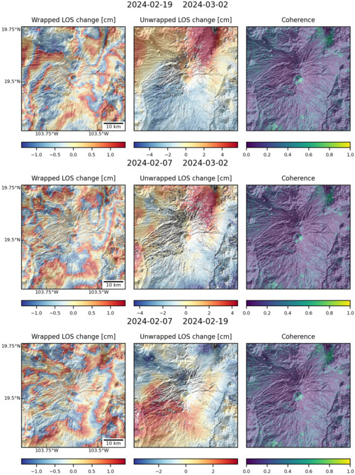
Latest Sentinel-1 Data
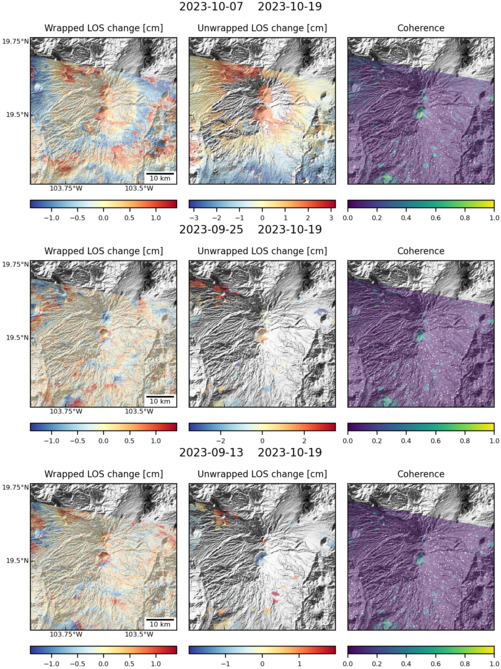
Size: 501px x 669px (170.57 KB)
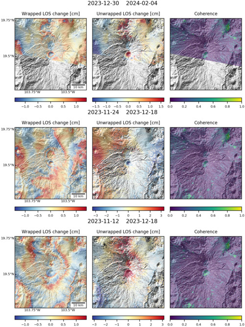
Size: 501px x 669px (176.21 KB)
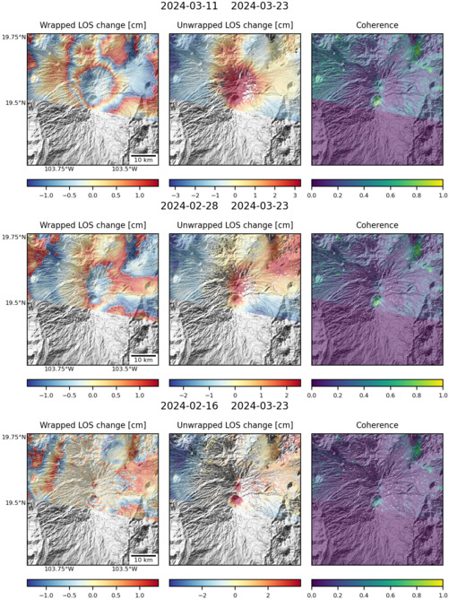
Size: 501px x 669px (165.47 KB)
Size: 501px x 669px (178.55 KB)