
Observations of Deformation
| Volcano number: | 221113 |
|---|---|
| Region: | Africa and Red Sea |
| Country: | Ethiopia |
| Geodetic measurements? | Yes |
| Deformation observation? | Yes |
| Measurement method(s): | InSAR, GPS - campaign |
| Duration of observation: | May 2005 - October 2005 |
| Inferred cause(s) of deformation: | Magmatic |
| Characteristics of deformation: | In 2005 a 60 km dyke, with 8 m opening, connecting the Manda Hararo and Dabbahu regions occured (Wright et al. 2012). Following the 2005 dyke intrusion 12 more dykes occured at Manda Hararo, and are discussed seperately on the Manda Hararo page. Wright et al. (2006) report that magma was injected along the 2005 dyke between depths of 2 and 9 km, corresponding to a total intrusion volume of |
| Reference(s): | Wright, T. J., Ebinger, C., Biggs, J., Ayele, A., Yirgu, G., Keir, D., & Stork, A. (2006). Magma-maintained rift segmentation at continental rupture in the 2005 Afar dyking episode. Nature, 442(7100), 291-294. |
| Grandin, R., A. Socquet, R. Binet, Yann Klinger, E. Jacques, J‐B. de Chabalier, G. C. P. King (2009). September 2005 Manda Hararo‐Dabbahu rifting event, Afar (Ethiopia): constraints provided by geodetic data. Journal of Geophysical Research: Solid Earth (1978–2012) 114. | |
| Hamling, Ian J., Atalay Ayele, Laura Bennati, Eric Calais, Cynthia J. Ebinger, Derek Keir, Elias Lewi, Tim J. Wright, and Gezahegn Yirgu. 2009. Geodetic observations of the ongoing Dabbahu rifting episode: new dyke intrusions in 2006 and 2007. Geophysical Journal International 178. 989-1003. | |
| NASA Landsat image, 1999 | |
| Pagli, C. et al., 2014. Current plate boundary deformation of the Afar rift from a 3-D velocity field inversion of InSAR and GPS. Journal of Geophysical Research: Solid Earth, 119(11), pp. 8562-8575. | |
| Location: | 12.595, 40.48 |
| REST API endpoint (JSON): | https://comet.nerc.ac.uk/wp-json/volcanodb/v1/volcano/1376 |
 2.5 km3. Wright et al. (2006) also present a 3D deformation field for the Dabbahu rifting episode derived from satellite radar data. The deformation field showsthat the entire segment ruptured, making it the largest to have occurred on land in the era of satellite geodesy. They report that much of the magma appears to have originated from shallow chambers beneath Dabbahu and Gabho volcanoes to the north, where an explosive fissural eruption occurred on 26 September 2005.
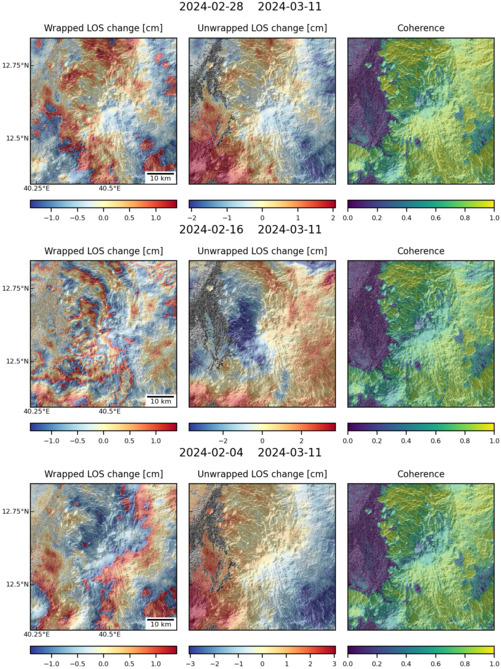
Latest Sentinel-1 Data
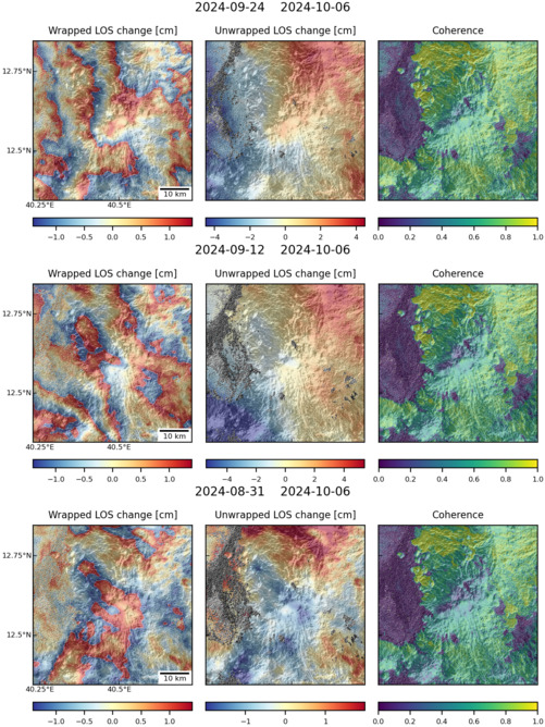
Size: 501px x 668px (174.61 KB)
Size: 501px x 669px (175.85 KB)