Observations of Deformation
| Volcano number: | 383010 |
|---|---|
| Region: | Atlantic Ocean |
| Country: | Spain |
| Geodetic measurements? | Yes |
| Deformation observation? | Yes |
| Measurement method(s): | InSAR, GPS - campaign, EDM, Gravity |
| Duration of observation: | 1992 to 2008 |
| Inferred cause(s) of deformation: | Magmatic, Surface deposits |
| Characteristics of deformation: | An EDM/GPS network was set up in 1994. Over three campaigns (spanning 1994 to 1997), no significant deformation was identified on the western flank of Cumbre Vieja (the last volcanic expression of a succession of growing and overlapping volcanic centers in La Palma). However, the area was limited to a fault previously active in 1949 (Moss et al., 1999). |
| Reference(s): | González, P. J., Tiampo, K. F., Camacho, A. G., & Fernández, J. (2010). Shallow flank deformation at Cumbre Vieja volcano (Canary Islands): Implications on the stability of steep-sided volcano flanks at oceanic islands. Earth and Planetary Science Letters, 297(3), 545-557. |
| Moss, J. L., McGuire, W. J., & Page, D. (1999). Ground deformation monitoring of a potential landslide at La Palma, Canary Islands. Journal of Volcanology and Geothermal Research, 94(1), 251-265. | |
| Prieto, J. F., González, P. J., Seco, A., Rodríguez-Velasco, G., Tunini, L., Perlock, P. A., ... & Fernández, J. (2009). Geodetic and Structural Research in La Palma, Canary Islands, Spain: 1992–2007 Results. Pure and applied geophysics, 166(8-9), 1461-1484. | |
| Perlock, P. A., González, P. J., Tiampo, K. F., Rodríguez-Velasco, G., Samsonov, S., & Fernández, J. (2008). Time evolution of deformation using time series of differential interferograms: Application to La Palma Island (Canary Islands). Pure and applied geophysics, 165(8), 1531-1554. | |
| Smithsonian Institution Global Volcanism Program http://www.volcano.si.edu/volcano.cfm?vn=383010 | |
| Location: | 28.57, -17.83 |
| REST API endpoint (JSON): | https://comet.nerc.ac.uk/wp-json/volcanodb/v1/volcano/1235 |
Latest Sentinel-1 Data
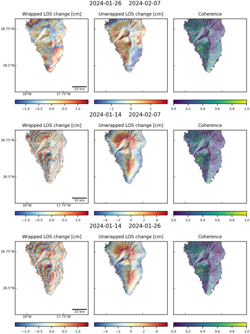
Size: 501px x 669px (95.21 KB)
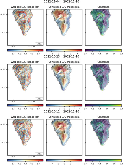
Size: 501px x 669px (95.52 KB)