Observations of Deformation
| Volcano number: | 311310 |
|---|---|
| Region: | Alaska |
| Country: | United States |
| Geodetic measurements? | Yes |
| Deformation observation? | Yes |
| Measurement method(s): | InSAR |
| Duration of observation: | 1993 - 2000, 2004 - 2009 |
| Inferred cause(s) of deformation: | Hydrothermal, Magmatic |
| Characteristics of deformation: | Between October 1993 and September 1995, interferograms show ~7 cm of uplift of Makushin volcano. This uplift is modelled using a point source located ~7 km beneath the volcano’s eastern flank, with a volume increase of 0.022 km³. Uplift is thought to be due to the accummulation of magma prior to an eruption of the volcano in January 1995. Interferograms spanning 1995 – 2000 and 2004 – 2009 subsidence of ~1 cm/yr. This subsidence is modelled by a source located at the same horizontal position and depth as that for preeruptive uplift. This suggests that subsidence could be caused by cooling and volatile loss from recently intruded magma. Other possible explanations include reduction of pore fluid pressure due to cooling and volatile loss from the hydrothermal system, or migration of magma/magmatic fluid to another reservoir. |
| Reference(s): | Lu, Zhong, Power, J. A., McConnell, V. S., Wicks, C. J., and Dzurisin, Daniel, 2002, Preeruptive inflation and surface interferometric coherence characteristics revealed by satellite radar interferometry at Makushin Volcano, Alaska: Journal of Geophysical Research, v. 107, n. B11, p. 1-13. |
| Lu, Z., and Dzurisin, D., 2014, InSAR imaging of Aleutian volcanoes: Chichester, UK, Springer-Praxis, 390 p. | |
| U.S. Geological Survey Alaska Volcano Observatory (AVO) website http://www.avo.alaska.edu/volcanoes/volcinfo.php?volcname=Makushin | |
| Location: | 53.891, -166.923 |
| REST API endpoint (JSON): | https://comet.nerc.ac.uk/wp-json/volcanodb/v1/volcano/5217 |
Latest Sentinel-1 Data
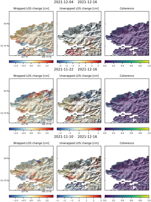
Size: 501px x 669px (135.53 KB)

Size: 501px x 669px (137.25 KB)
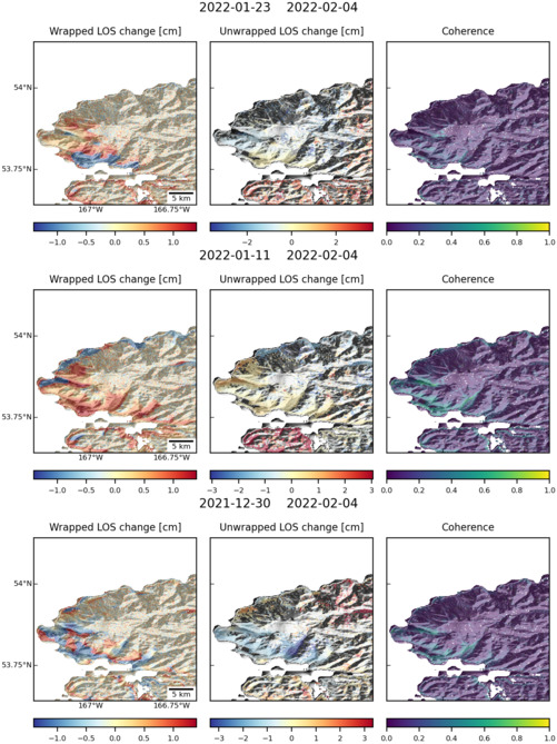
Size: 501px x 669px (136.49 KB)