
Observations of Deformation
| Volcano number: | 321050 |
|---|---|
| Region: | Canada and Western USA |
| Country: | United States |
| Geodetic measurements? | Yes |
| Deformation observation? | Yes |
| Measurement method(s): | InSAR, GPS - continuous, GPS - campaign, Tiltmeter, EDM, Photogrammetry, Dry-tilt, Rapid response GPS "spiders" |
| Duration of observation: | 1972, 1980 - present |
| Inferred cause(s) of deformation: | Magmatic, Eruption |
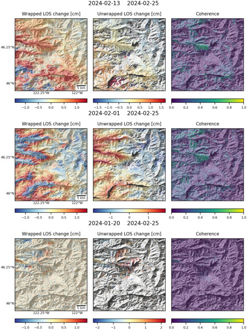
| Characteristics of deformation: | In 1972 several baseline distance measurements were made at St Helens, but these were not repeated prior to the onset of activity in 1980. Deformation measurements throughout the eruption were made using EDM, dry-tilt, photogrammetry and tiltmeters. At the peak of activity, photogrammetry revealed over 100 m of deformation on the upper north slope, and continual lateral displacements at 2.5 m/day. Following the eruption, tilt data showed slow deflation interupted by brief periods of inflation that preceeded pyroclastic flows (Lipman and Mullineaux, 1981). The first continuous GPS instrument was installed at St Helens in 1997 and in 2000 the U.S. Geological Survey Cascades Volcano Observatory (CVO) established a campaign GPS network of over 40 stations. Repeat measurements of this network were made in 2003 but showed no evidence of volcano-wide deformation. This is in agreement with InSAR studies between 1992 – 2004, which also showed no measureable deformation (Sherrod et al. 2008). In 2004 a swarm of earthquakes marked the onset of renewed unrest at the volcano, and the continuous GPS station recorded motion downwards and inwards. In response to this, the campaign network was resurveyed and 11 new continuous GPS receivers were installed. All instruments recorded subtle (max 3 cm) but widespread deflation of the volcano. InSAR observations of the eruption were dominated by atmospheric artefacts, but interferograms support subsidence of the edifice at up to 1 cm/yr. Inward and downward movement is interpreted to be due to depletion of a ~7 km depth magma reservoir. Following the eruption there was a slight reversal in the deformation signal (inflation) of up to 1 cm, interpreted to be due to repressurisation of the reservoir (Sherrod et al. 2008). Throughout the eruption, GPS “spiders” were developed and deployed by the CVO to record deformation associated with lavadome growth. These instruments were dropped from a helicopter onto the erupted spines providing direct measurements of the extrusion rate. During the eruption a network of tiltmeters was also installed . Instruments close to the vent recorded thousands of events typically consisting of rapid tilt of the ground away from the vent followed by a gradual reversal. This is consistent with slow extrusion of a plug of lava caused by cycles of pressurization within the volcanic conduit near the shallow (< 1 km deep) interface between the rising plug and the 1980s lava dome (Anderson et al. 2010). The tilt events ceased when the eruption ended in late January 2008. |
| Reference(s): | Lipman, P. W., Mullineaux, D. R. (Eds.) (1981. The 1980 Eruptions of Mount St. Helens, Washington. U.S. Geological Survey Professional Paper , 1250, 844 p. http://pubs.er.usgs.gov/publication/pp1250. |
| Sherrod, D. R., Scott, W. E., Stauffer, P. H. (Eds.) (2008) A Volcano Rekindled: The Renewed Eruption of Mount St. Helens, 2004-2006. U.S. Geological Survey Professional Paper , 1750, 856 p. | |
| Anderson, K., Lisowski, M., Segall, P. (2010) Cyclic ground tilt associated with the 2004–2008 eruption of Mount St. Helens. Journal of Geophysical Research , 115, 29 pp. doi:10.1029/2009JB007102. | |
| U.S. Geological Survey Cascade Volcano Observatory (CVO) http://volcanoes.usgs.gov/volcanoes/st_helens/st_helens_monitoring_103.html | |
| Location: | 46.2, -122.18 |
| REST API endpoint (JSON): | https://comet.nerc.ac.uk/wp-json/volcanodb/v1/volcano/472 |
Latest Sentinel-1 Data
Size: 501px x 669px (184.30 KB)