An international collaboration between Professor Zhenhong Li’s team at Newcastle University and the China Academy of Space Technology (CAST) has generated interferograms using Chinese Gaofen-3 (GF-3) imagery for the first time. These are also the first interferograms from Chinese SAR missions.
GF-3 was launched from the Taiyuan Satellite Launch Centre on 10 August 2016, and has been in operation since January 2017. With its multi-polarised C-band Synthetic Aperture Radar (SAR) sensor featuring a large radar antenna 15 m in length, GF-3 is able to
image the Earth’s surface in all weather conditions and regardless of day or night.
Circling the Earth in a sun-synchronous dusk-dawn orbit at 755 km altitude, GF-3 can operate in 12 different working modes, from high-resolution (1 m) to extremely-wide-swath (650 km), from single to full polarisation.
Due to its wide incidence angles and dual-sidelooking capability, GF 3 has a quick site access time of 3.5 days at most (1.5 day at 90% probability) to any point on the Earth.
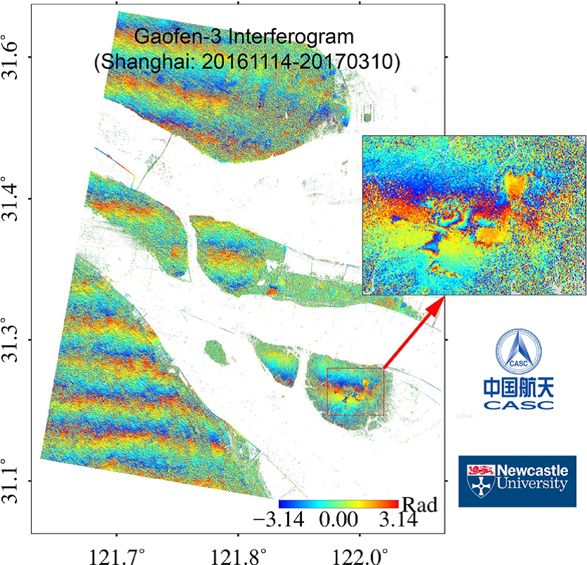
116 days; Spatial baseline (orbital separation): 598 m; (ii) the long-wavelength parallel
fringes are caused by the uncertainties in satellite orbital positions; (iii) About two fringes are
observed in the area indicated by a red rectangle, implying c. 5.6 cm of subsidence (likely
caused by groundwater extraction) during the 116-day period.
SAR satellites emit radar waves and measure the amplitude and phase (fraction of the full wave) of the reflected waves for each pixel in the image. SAR interferometry (InSAR) combines two (accurately aligned) SAR images of the same area into an ‘interferogram’ by
computing the differences in the phase of the radar waves.
The resulting interferogram shows us how big the ground movement is for each pixel. Figure 1 shows the first GF-3 interferogram of approximately 50 x 50 km around Shanghai, China. Two fringes (equivalent to c. 5.6 cm of subsidence) can be observed in the GF-3 interferogram with a time span of 116 days.
Figure 2 shows one GF-3 interferogram over the city of Huanghua, Hebei Province in China. It is clear that Nandagang Wetland Conservation Area exhibited uplift signals even during such a short period (only 29 days).
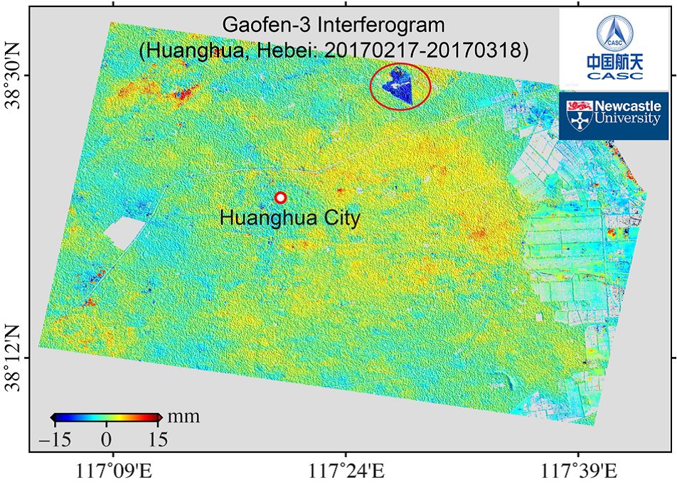
(i) Time span: 29 days; Spatial baseline (orbital separation): 250 m; (ii) The range changes
in the radar line of sight (LOS) are shown. Positive implies that the surface moves away from
the satellite (i.e., the pixel exhibits subsidence), and negative implies uplift in LOS; (iii)
Uplift signals are observed in Nandagang Wetland Conservation Area (denoted by a red
ellipse).
“GF-3 is China’s first high resolution SAR satellite. In the satellite development phase, we managed to develop and/or implement nine key technologies including multi-mode combined ocean and land imaging and multi-polarised phased array antenna.” said Professor Qingjun Zhang, CAST’s GF-3 Mission Manager.
“In the operational phase, we generated the first GF-3 interferogram; this was also the first time that an interferogram was
produced from Chinese SAR satellites, which really is a milestone in China radar community.”
Professor Li, the European Lead PI of ESA-MOST Dragon-4, added “Our experiments have demonstrated that the GF-3 phase quality is in a high standard with a high spatial resolution (3.5 m in azimuth and 5.5 m in range), leading to high coherence even for interferograms with a spatial baseline of c. 600 m and a temporal
baseline (time span) of nearly 4 months”
“This implies that Chinese radar missions have already reached the international advanced level.”
Dr Yadong Liu, Senior Engineer at CAST and Ms Jiajun Chen, PhD candidate at Newcastle University agreed, “GF-3 has great potential for InSAR application.”
The team will now promote GF-3 by continually acquiring GF-3 imagery over some selected areas with scientific
and/or engineering interests, improving its data quality, refining its satellite orbits, and further developing interferometric processing algorithms (e.g. automatic processing chains). More applications will be explored in the future.