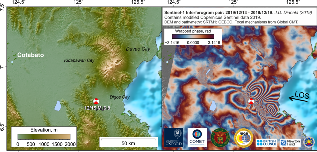
COMET made important contributions to real-time response to a series of four significant earthquakes in the island of Mindanao in the south of the Philippines. Following a peculiar and devastating series of magnitude 6+ earthquakes all within 20 kilometers of each other, between 16-31 October 2019, and a magnitude 6.7 earthquake in 15 December 2019 in the same region, Sentinel-1 and ALOS-2 satellite radar data processing to produce ground deformation maps was initiated by COMET. Coordination with ESA allowed rapid satellite tasking, data analysis, and discussion with colleagues at the National Institute of Geological Sciences of the University of the Philippines (UP) and the Philippine Institute of Volcanology and Seismology (PHIVOLCS), in aid of efforts to map the effects of the earthquakes and the search for usually elusive fault ground rupture. Remote sensing analysis by COMET was particularly helpful in targeting areas for detailed field investigation, especially as the surrounding volcanic terrain makes field work challenging. Preliminary findings were directly issued to and acted upon by the local government for disaster mitigation, and parallel scientific investigations by COMET and the Philippine colleagues are currently in the works.
Much of the efforts that maximize the impact and reach of COMET expertise stems from the continued building of soft and hard linkages by COMET with scientists and academics in the international community, with the response to the Philippine earthquakes and data analysis led by UP faculty and concurrent COMET student, J.D. Dianala (Oxford), and Yu Morishita, GSI Japan scientist and COMET Visiting researcher (Leeds) from 2018-2020.