High-resolution maps showing ground movement are now free to download thanks to a new service developed by the UK Centre for the Observation and Modelling of Earthquakes, Volcanoes and Tectonics (COMET), in partnership with the Looking inside the Continents from Space (LiCS) and Earthquakes without frontiers projects.
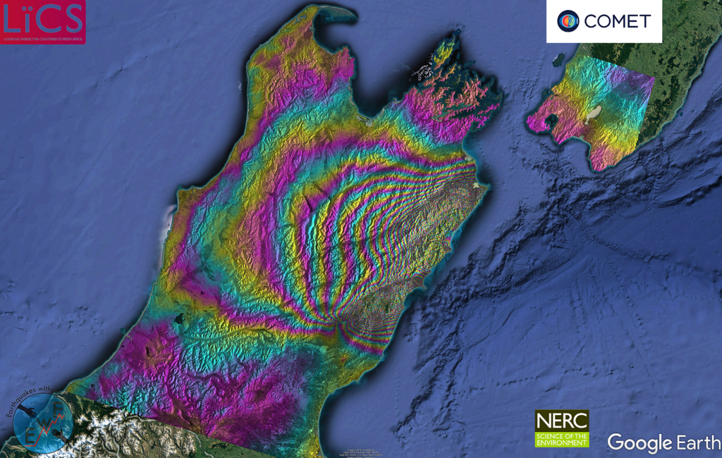
The COMET-LiCS Sentinel-1 InSAR portal is providing access to results from LiCSAR, a system developed to process the vast amounts of data generated daily by the EU’s Sentinel-1 satellite constellation.
LiCSAR is now providing high-resolution deformation data for the entire Alpine-Himalayan seismic belt, where most of the planet’s deadly earthquake occur.
Since its launch in October 2014, Sentinel-1 has been acquiring radar images across the globe. By combining these images using a technique called radar interferometry, or InSAR, COMET scientists are able measure subtle movements in the Earth’s crust.
But Sentinel-1’s extensive coverage and regular acquisitions also mean that it sends back huge volumes of raw data which need to be translated into useful information. LiCSAR was developed in direct response to the challenges of extracting information on tectonics from this unprecedented volume of satellite data.
Crucially, LiCSAR can automatically produce updated deformation results within a few hours of the satellite passes.
For example, data acquired over Turkey has been used to chart the westwards motion of the Anatolian plateau relative to Eurasia, and in turn interpret how tectonic strain is building up along the North and East Anatolian Faults.

As the techniques are refined and the service expanded across the globe, LiCSAR will be able to measure tectonic strain with a level of accuracy similar to existing ground-based GPS networks (movements of 1 mm per year across distances of 100 km) but with far greater geographic coverage.
At the same time, as Sentinel-1 revisits the same areas over and again during its 20-year lifetime, LiCSAR will be used to create a long-term record of ground movement, helping scientists to assess how and where tectonic strain is accumulating.
It will also highlight how and where the ground is deforming around volcanoes, which will help scientists to better understand changes in volcano behaviour including potential signs of eruption.
COMET Director Tim Wright summarised: “LiCSAR is massive step forward in providing open data on earthquakes, tectonics and volcanoes, vastly improving access to vital information on how our dynamic planet is deforming.
“We are now looking forward to expanding the service to provide global coverage within the next few years, which will be critical in helping the scientific community and people on the ground to understand and manage geohazards”.
Notes
The COMET-LiCS Sentinel-1 InSAR portal can be found at https://comet.nerc.ac.uk/COMET-LiCS-portal
This work is funded by the UK Natural Environment Research Council through the Centre for the Observation and Modelling of Earthquakes, Volcanoes and Tectonics (COMET), the “Looking inside the Continents from Space” large grant (NE/K011006/1), and the “Earthquakes without Frontiers” project (NE/J01978X/1).
Please cite the following publication if you use data from the service:
Gonzalez, PJ; Walters, RJ; Hatton, RL; Spaans, K; McDougill, A; Hooper, AJ; Wright, TJ, LiCSAR: Tools for automated generation of Sentinel-1 frame interferograms, AGU Fall Meeting, 2016