David Arnold, COMET Research Student (Bristol)
David is a postgraduate at the University of Bristol working in the areas of volcanology, geohazards and risk, with a focus on agile InSAR for volcano monitoring.
Following a large explosive volcanic explosion in 2002, El Reventador, Ecuador has experienced several periods of eruption, the most recent of which is still ongoing. Satellite remote sensing is being used to monitor the eruption.
El Reventador is located in a remote part of the Ecuadorian rainforest, but can still have a significant impact on human population – ash fall from the 2002 eruption caused power outages and cancelled flights in the Ecuadorian capital, Quito, and pyroclastic flows and lahars damaged a nearby road and oil pipeline. El Reventador’s remoteness makes it difficult to monitor with ground based techniques, since maintaining instruments either requires good enough weather conditions for a helicopter to land technicians near the volcano, or a long trek through dense jungle. Satellite based remote sensing therefore provide an ideal technique for monitoring the ongoing eruption, especially SAR due to its ability to make observations through clouds and at night.
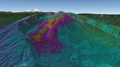
Working with colleagues in Ecuador, data from Radarsat 2 and TanDEM-X has been used to map the emplacement of lava flows throughout the most recent phase of the eruption at El Reventador, which began in 2012. Using the high-resolution data provided by these satellites allows precise estimations of the thickness of lava flow deposits, which reach up to 75 m in places. Looking at variations in the erupted lava volume through time allows the rate of eruption to be estimated and how this is changing as the eruption progresses to be modelled.

Topographic fringes from a TanDEM-X image pair, showing the thickness of recent lava flows at Volcán El Reventador, Ecuador, as viewed from the southeast. One complete colour cycle corresponds to 25 m of new lava. Images like these supplement limited ground-based measurements, and make it possible to see how the rate of eruption is changing over time
The findings show that the eruption rate has decayed with an approximately exponential trend over the past 5 years. The decrease in eruption rate can be explained with a model for the magmatic system which suggests there is a single reservoir beneath El Reventador that is depressurising as the eruption progresses, and is resupplied with magma from below at a low, but constant, rate.
Radarsat 2 interferograms have also been used to monitor ground deformation at El Reventador, which is mostly associated with subsidence of cooling lava flows. Measurement of one magmatic deformation episode has been attributed to a volumetrically small opening of the conduit shortly after the start of activity in 2012, but there is no evidence for magmatic deformation after this. Deformation signals associated with magma intrusion would indicate an increase in magma supply to the volcano, which could mean an increase in the hazard posed by the volcano to nearby infrastructure.
