Category Archives: Uncategorised

Marek ziebart wins tycho brahe award

The outstanding contributions of COMET UCL’s Professor Marek Ziebart to the science of space navigation, guidance and control have been recognised with a prestigious award from the US Institute of Navigation.

The Tycho Brahe Award is bestowed annually to an individual who has made a truly significant contribution to the science of spacecraft navigation and whose actions have benefited civilisation in any form.

Marek, who is Professor of Space Geodesy in the UCL Department of Civil, Environmental and Geomatic Engineering, focuses on the design of innovative navigation systems for spacecraft, including a navigation and communications system for manned and robotics missions to Mars and the moon between 2020 and 2040.

The US Institute of Navigation cited his outstanding innovation and leadership in the area of high precision, physics-based radiation force modelling for spacecraft orbit dynamics. His work has revolutionised the precision of satellite orbit modelling and led to a long running and successful collaboration with NASA Goddard Space Flight Center, where his methods have been applied to many NASA missions, including the Jason-1 satellite of the Ocean Surface Topography Mission to measure Earth’s sea levels.

Professor Ziebart said: “In receiving this award I’d like to acknowledge the help and support of my colleagues and the faculty at UCL. To me it seems that in this extraordinary institution you get smarter simply by osmosis. I feel privileged to be a part of UCL and working on research that is truly impactful and beneficial to the planet as a whole.”

The award was presented at a ceremony at the US Institute of Navigation in Washington on 31st January, 2019.

Tamsin Mather receives 2018 Rosalind Franklin Award from Royal Society

COMET Oxford’s Professor Tamsin Mather is the latest recipient of the Royal Society’s Rosalind Franklin Award, recognising her achievements in volcanology as well as her ability to engage with the public about her research.

The award is made to an individual for an outstanding contribution to any area of Science, Technology, Engineering and Mathematics (STEM) and to support the promotion of women in STEM.

Tamsin will receive a silver gilt medal at her Award Lecture in October 2018.  Congratulations Tamsin from all of your COMET colleagues.

Permafrost dynamics in the remote Canadian Arctic revealed by high-resolution topographic measurements

Pablo J Gonzalez is a COMET researcher at the University of Liverpool.  He is currently (August 2017) carrying out a field campaign in the Canadian Arctic funded by the NERC British Arctic Office under the UK-Canada bursaries project Ice-landforms characterization due to permafrost dynamics around the Pingo National Landmark, Tuktoyaktuk, Northwest Territories, Canada.

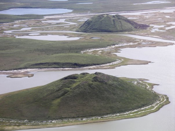
Permafrost dynamics, related to ice aggradation and thawing, are effective climatic indicators.  Pingos (conical ice-cored hills, Fig. 1) concentrate large amounts of ice near the surface and, hence are highly sensitive systems to environmental changes.

Figure 1. Pingo National Landmark is a unique area with a high density of ice-landforms in Canada, hosting around 10% of pingos in the world. Credit: Wikipedia

Thus, the morphology and dynamics of pingos can be used to monitor regional effects of climate change over wide regions in the Arctic. However, we can identify two main difficulties in using pingos for environmental monitoring:

  1. The relationship of pingo morphology with its origin and permafrost conditions has not been established quantitatively.
  2. Monitoring pingo dynamics (growth, stability or collapse) has not been possible due to their small size (<300 m) and remote locations.

In this project, we aim to increase our understanding of pingo dynamics to fully exploit their potential as climate indicators. Here, we will apply novel methods to retrieve high spatial resolution (1-m) and very-high precision (<1m) topography based on satellite and drone technology.

The essential field work (late August 2017) is being carried out in collaboration with scientists from the Canada Centre for Remote Sensing, Natural Resources Canada (Dr. Yu Zhang and Dr. Sergey Samsonov), who are currently working in the area under the Polar Knowledge Canada project “Monitoring Land Surface and Permafrost Conditions along the Inuvik-Tuktoyaktuk Highway Corridor”.

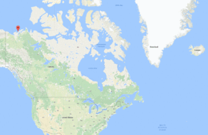
This UK-Canada project will establish, for the first time, new and unique morphometric descriptions of a large number of pingos; conduct an exploratory analysis to establish links between current morphology with respect to genetics (origin), environmental conditions and stage of evolution; and unequivocally demonstrate the systematic decline, stability or growth of pingos in Tuktoyaktuk (Fig. 2), which could be linked to current climate change in the Western Canadian Arctic.

Figure 2. Location of Tuktoyaktuk, Northwestern Territories, Canada. Credit: Google Maps