
InSAR has been widely integrated into Earth surface deformation studies from a geophysical point of view. What makes LiCSAR special is its accessibility, providing the potential to expand the Sentinel-1 user base to include non-expert geophysicists as well as users from new fields such as civil engineering, urban planning and monitoring and the social sciences.
The Sentinel-1 satellite constellation is proving a game changer for monitoring deformation of the Earth’s surface. Over the last two years, numerous earthquakes and volcanic eruptions have been imaged with Sentinel-1 interferograms, aiding rapid response and resulting in a greater scientific understanding of these events and their geophysical properties.
However, the main reason that Sentinel-1 is a game changer is the freely available, enormous data volumes that it acquires, allowing unprecedented coverage of areas studied using the technique. Processing this data nonetheless presents a big challenge.
To address this, COMET is developing a system capable of processing all data acquired globally, with the resulting products freely accessible and downloadable through an online portal, to include both wrapped and unwrapped interferograms, coherence estimates, velocity estimates and metadata.
The portal will allow quick access to already processed products, providing a convenient service not just to scientists already familiar with InSAR, but also opening up possibilities for non-expert users.
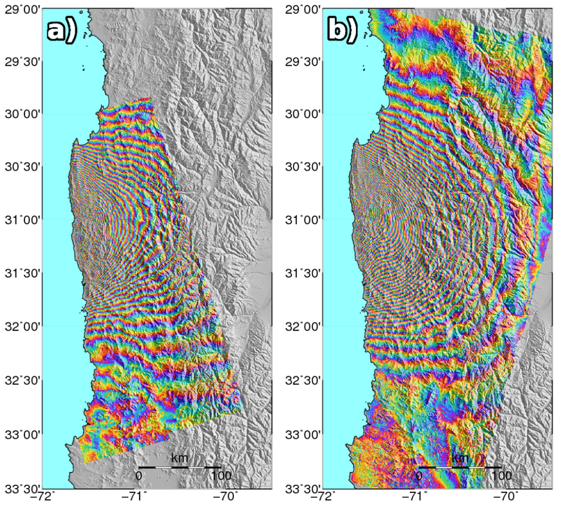
Several members of COMET have put considerable effort into getting the system operational. In 2015, the Gamma software package was chosen as the basis for the processing system. A batch processing shell was developed around the Gamma software, which has been available for general use within COMET since early 2016 and used by COMET scientists to image several earthquakes, long term tectonic movements and volcanic eruption. These include large events such as the Illapel, Chile earthquake, imaged by Sentinel-1 data in exquisite detail (Figure 1).
Processing is mainly supported by the CEMS facility maintained by CEDA. All COMET scientists have access to a high powered processing cluster here, and a full mirror of the Sentinel-1 archive located at the facility means that data does not have to be downloaded before processing, greatly reducing the time necessary to obtain results.
The next challenge involved automating the processing system, allowing it to handle large volumes of data without the need for human interaction. This added a new layer of complexity to the system, requiring the development of a database system for raw data and processed products, and a daemon system that handles the decision making of which products to process, plus performing housekeeping on processing results.
This automated processing system has been developed in-house by the COMET team, and finishing touches are being put on the system at the time of writing. In the meantime, the team has been delivering wrapped interferograms and coherence estimates for data acquired since September 2016 over the Alpine-Himalayan belt, available via the COMET/LiCS InSAR portal.
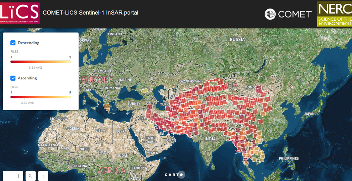
This screengrab of the portal provides an idea of the LiCS processing system coverage. The interface provides an overview of data availability, and data downloads are easily accessible through clicking on the scene polygons.
The next steps are to include unwrapped interferograms and linear time series in the data portal, as well as extending the time series to include all historically available data. In addition, there are plans to include an automatic fast response system into the processor that prioritises rapid data processing of scenes that contain an earthquake or volcanic eruption.
In the long term, the system will be expanded to process all data worldwide. It will also include nuisance term corrections, like tropospheric and ionospheric corrections, and increase the effectiveness of the time series analysis. All this will result in a system that provides a consistent, robust and reliable stream of data, useful for both expert and non-expert users.