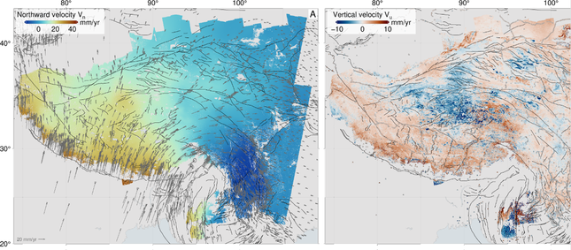
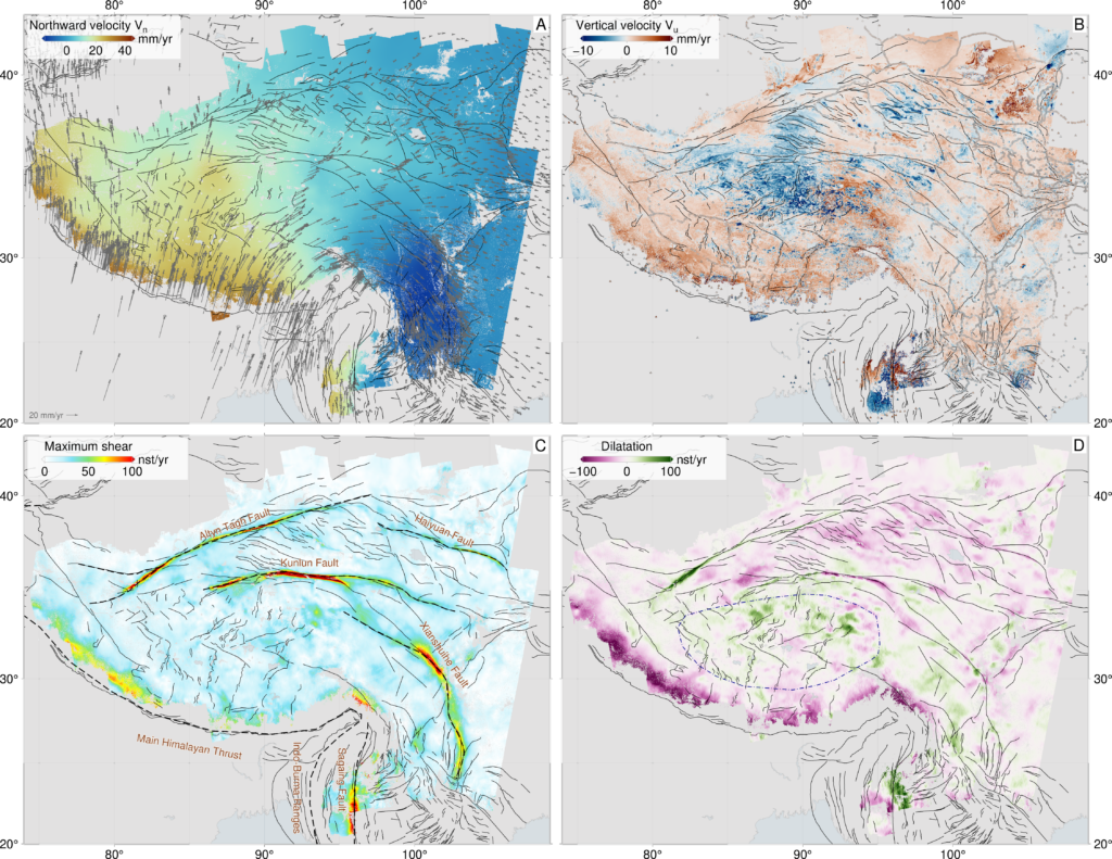
A high-resolution map of the Tibetan Plateau reveals that major faults are far weaker than expected, pointing to slow, continent-wide flow rather than rigid block motion.
Scientists have created the most detailed map ever produced of how the largest region of active continental movement on Earth, the Tibetan Plateau, is stretching, squeezing, and shifting in unexpected ways.
The results, published in Science, overturn longstanding ideas about how continents deform, and reveal that the interior of Asia is best explained as a flowing material, guided by weak faults.
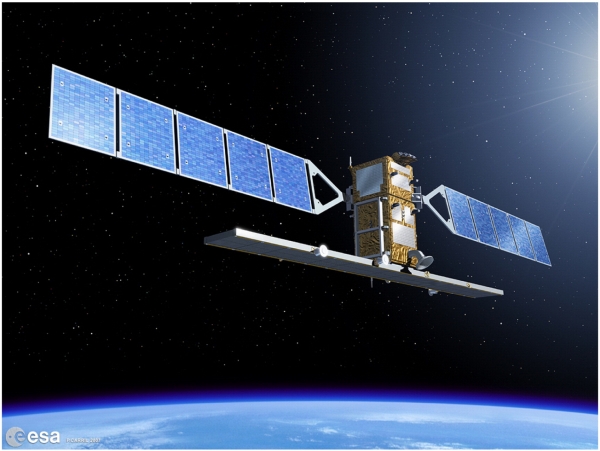
This analysis draws on tens of thousands of satellite images and one of the most extensive geodetic datasets ever assembled. Using more than 44,000 radar images from the European Space Agency’s Sentinel-1 satellite, over 340,000 maps showing ground movement (interferograms), and 14,000+ Global Navigation Satellite System (GNSS) measurements, the research team produced an unprecedented, millimetre per year scale velocity map of the entire plateau. This is the highest resolution view to date of how the collision between India and Eurasia, one of the most powerful tectonic events on the planet, is reshaping Asia.
“This is the clearest picture yet of how a continent deforms under extraordinary forces,” said lead author Tim Wright (University of Leeds / COMET). “By mapping motion across the whole region in incredible detail, we can finally see how the Tibetan Plateau is actually moving, and the story it tells is very different from what the old models predicted.”
Weak faults, flowing continents
Conventional models often treat Tibet as a mosaic of strong, rigid blocks separated by major faults that slip horizontally past each other. But when the team compared their high-resolution movement map with dynamic models of continental flow, they found a striking mismatch: the observations can only be explained if the major fault systems, including the Kunlun Fault system, which failed in very large earthquakes in 1997 and 2001, are weak, offering little resistance to deformation.
“The data show that continents don’t behave like a mosaic of stiff plates. They flow, but their flow is enabled by major faults, which act as weak zones,” said co-author Greg Houseman (China University of Geosciences Beijing and University of Leeds). “This helps explain why the extension in southern and central Tibetan plateau is so widespread.”
Why central Tibet is stretching apart
One of the most surprising findings is a clear explanation for Tibet’s widespread east–west extension, particularly in the plateau’s interior. The new models show that to match the observations the Kunlun Fault must be extremely weak, allowing the northern edge of central Tibet to slide freely relative to the region north of it. This weak boundary enables the plateau interior to collapse and stretch east–west, releasing gravitational potential energy accumulated by the immense thickness of the crust.
“The weakness of the Kunlun Fault is the key that unlocks what’s happening in central Tibet,” said coauthor Jin Fang (University of Leeds / COMET). “It allows the interior of the plateau to essentially flow eastwards, helping to explain the region’s widespread extension, something that has puzzled geologists for decades.”
A new framework for understanding continental interiors
The study’s findings reshape scientific understanding of how continental interiors respond to largescale tectonic forces. By demonstrating that weak faults and viscous-like flow dominate deformation across the Tibetan Plateau, the work provides a more physically realistic foundation for future research on mountain building, continental dynamics, and long-term seismic hazard across Asia.
“This is a fundamentally new way of looking at how continents work,” said Wright. “And with next generation satellites and global coverage, this approach could soon give us similarly detailed maps for deforming regions all around the world.”
Around three quarters of the world’s deadliest earthquakes occur in continental interiors. The new tools and maps produced by the research team are already being used to improve seismic hazard models used to help countries and communities prepare for earthquakes.
This research, led by Tim Wright (University of Leeds/COMET), is a collaboration between the UK Centre for Observation and Modelling of Earthquakes, Volcanoes and Tectonics (COMET) across the universities of Leeds, Edinburgh, Exeter, and Oxford, and the China University of Geosciences (Beijing, China), Monash University (Australia), GNS Science (New Zealand), Columbia University (New York, USA) and South China Agricultural University (Guangzhou, China).
The research was funded primarily by the UK Natural Environment Research Council (NERC), with additional support from the Royal Society and the National Natural Science Foundation of China.
The UK Centre for Observation and Modelling of Earthquakes, Volcanoes and Tectonics (COMET) is a trusted centre of excellence in volcanic and earthquake science, combining expertise in observations and hazard modelling to deliver accessible data and advice for global risk reduction and resilience. COMET brings together world-leading scientists across 16 UK universities, the British Geological Survey (BGS), and external partners.
Professor Richard Walker and Dr Neill Marshall discuss their work on past earthquakes to better understand the current seismic hazard risk in Central Asia in this short documentary.
“This is a topic that is of continued importance and urgency due to the fast pace of urban growth and infrastructure development across the region: the more we can identify now will help us build a more resilient future.” Professor Richard Walker
Thanks go to Oxford Earth Sciences, Reuben College, University of Oxford The Leverhulme Trust, UK Centre for Observation and Modelling of Earthquakes, Volcanoes and Tectonics, and all of those who have supported this work, including Dr Charlotte Bird and the Oxford Sparks team.
We are delighted to celebrate COMET Scientists Professor Marie Edmonds (University of Cambridge) and Professor David Pyle (University of Oxford), who are amongst the outstanding and distinguished group of scientists elected Fellows of the Royal Society this year. This prestigious title is awarded to scientists who have made exceptional contributions to science, and the ground-breaking work that both professors have undertaken throughout their careers is certainly deserving of this honour.
Professor Marie Edmonds FRS – University of Cambridge
Professor Marie Edmonds is an Earth Scientist whose interdisciplinary research spans volcanology, igneous petrology, tectonics, atmospheric science and economic geology. Her work focuses on understanding how certain elements move through the Earth system – elements that are essential for creating a habitable planet, powering volcanic eruptions, and concentrating valuable metals in the Earth’s crust.
Professor Edmonds has significantly advanced our understanding of how volcanoes work and their broader impacts on our planet. She has developed new ways to monitor volcanoes by studying the gases they release, helping scientists better predict when eruptions might occur and assess the risks they pose to nearby communities. Her research has also revealed how carbon moves through the Earth over millions of years, providing vital insights into long-term climate change. She has shown how hot, mineral-rich fluids from deep within the Earth create the metal deposits we rely on for modern technology, and has reconstructed huge ancient eruptions to understand how they altered Earth’s climate and environment in the past.
As Professor of Volcanology and Petrology and Head of the Earth Sciences department at the University of Cambridge, Professor Edmonds also serves as the Ron Oxburgh Fellow and Vice President of Queens’ College, Cambridge. Her excellence has also been recognised through membership of the Academia Europaea and the American Geophysical Union College of Fellows.
Professor David Pyle FRS – University of Oxford
Professor David Pyle’s fascination with volcanoes began early; he saw his first volcano at age seven in Chile, sparking a lifelong interest that would shape his distinguished career. After studying geological sciences at the University of Cambridge and completing his PhD on the volcanic histories of Santorini, Greece, and Oldoinyo Lengai, Tanzania, he has dedicated his research to quantifying the scale of volcanic eruptions and understanding their processes and impacts.
As Professor of Earth Sciences at the University of Oxford, Professor Pyle’s research combines geological fieldwork with archival records to build comprehensive pictures of volcanic activity. His work includes creating detailed eruptive histories of individual volcanoes to global-scale analyses, encompassing young and active volcanoes on Earth as well as investigations relevant to the early Earth and other planetary bodies. This broad perspective has contributed significantly to our understanding of volcanism across space and time.
Beyond his research excellence, Professor Pyle has demonstrated exceptional commitment to outreach and public engagement with science. He curated the ‘Volcanoes’ exhibition at the Bodleian Library, Oxford in 2017, authored two books, and helped lead two Royal Society Summer Science exhibits: ‘Fast and Furious’ in 2010 and ‘Sensing Volcanoes’ in 2023. His contributions to the field were recognised with the prestigious Murchison Medal of the Geological Society of London in 2024.
A Celebration of Earth Sciences Excellence
The election of both Professor Edmonds and Professor Pyle as Fellows of the Royal Society represents a tremendous achievement for Earth sciences, highlighting the vital importance of understanding our planet’s dynamic processes. Their complementary expertise demonstrates the breadth and depth of excellence in volcanic research.
We extend our warmest congratulations to Professor Marie Edmonds FRS and Professor David Pyle FRS on this prestigious honour!
On 28th March 2025, a 7.7-magnitude earthquake struck Myanmar, affecting large areas of the country and causing widespread destruction. A powerful 6.4-magnitude aftershock followed 12 minutes later, approximately 31 kilometres south of the initial shaking. The country, and surrounding areas, were also subjected to hundreds of smaller aftershocks for weeks after the initial event. Myanmar’s military government have estimated that the death toll has surpassed 3,000 people and an additional 4,500 have suffered injuries. The shallow depth of the earthquake (~10km) caused violent ground shaking and extensive damage to local buildings and infrastructure.
Data from ESA’s Sentinel-1 satellite first captured on 29th March clearly show the physical effects of the earthquake on the region. The earthquake ruptured a remarkably long and simple fault, around 500 km in total length, with a relative motion across the fault of up to around 6 m (west side to the north, east side to the south). Although most of the motion is horizontal, there is also a vertical offset of around 1 m across the fault (east side down).
One of Myanmar’s largest cities, Mandalay, sits close to this extensive ground movement (at around 22°N), explaining the significant human and structural impact of the event.
By combining Sentinel-1 imagery from before and after the earthquake, COMET scientists have been able to measure surface deformation that is clearly visible in the data sets shown below:
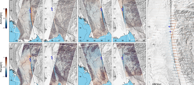
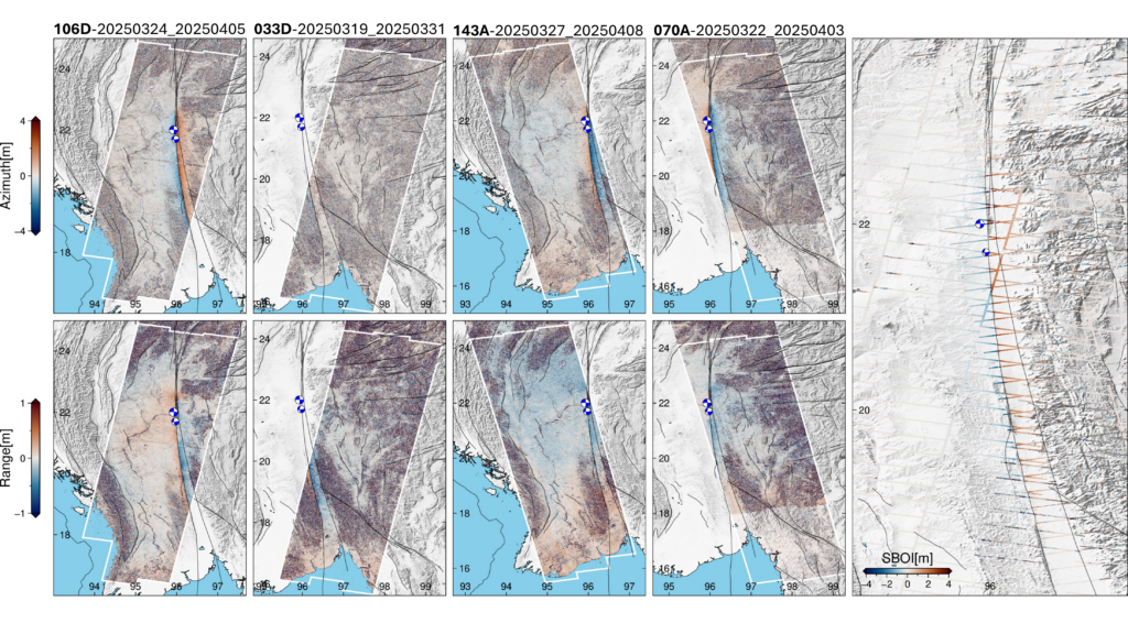
Figure 1: Data from four Sentinel-1 tracks (2 ascending and 2 descending), each consisting of three standard LiCSAR frames (~13 bursts per subswath), were used to cover the deformation zone. Azimuth offsets (top panels) capture along-track (north–south) deformation. Range offsets (bottom panels) represent Line-of-Sight (LoS) deformation. Burst Overlap Interferometry (right) provide high-resolution along-track deformation. Red indicates southward, and blue indicates northward motion.
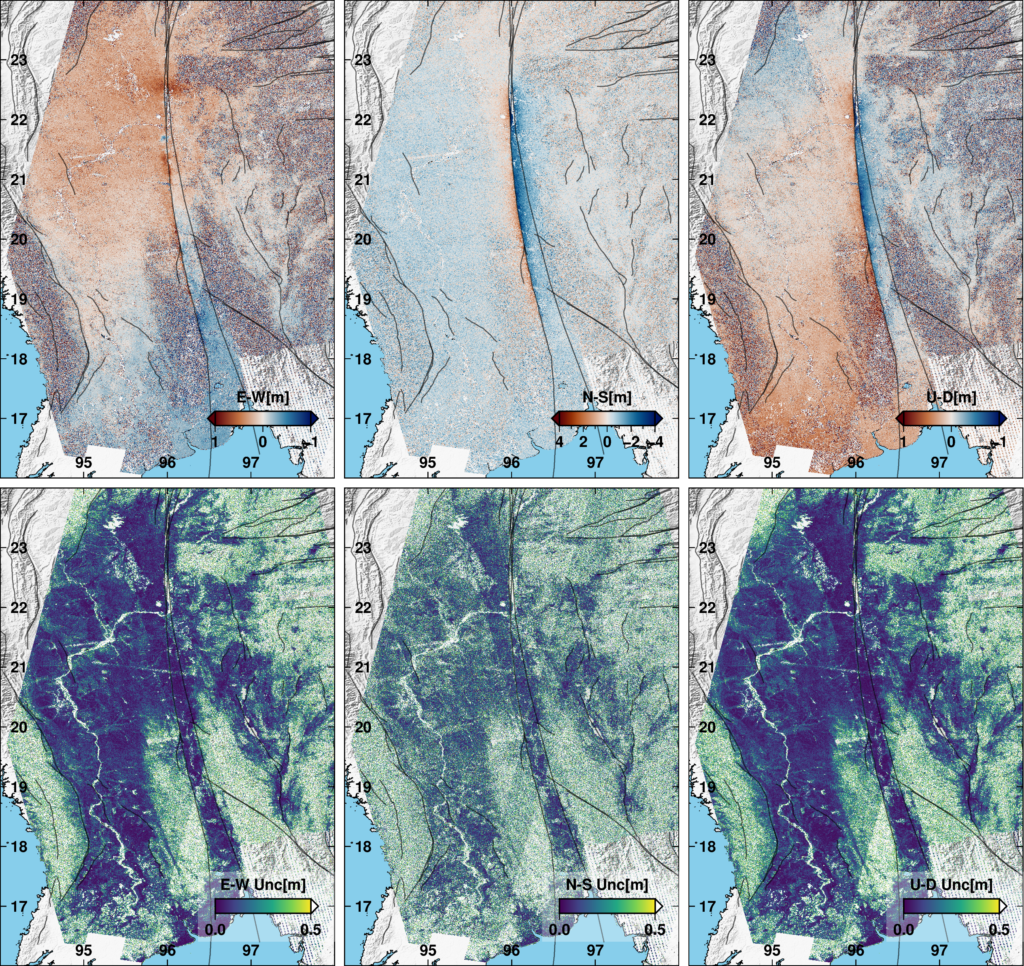
Figure 2: 3D co-seismic displacement fields and associated uncertainties were estimated using a Weighted Least Squares approach applied to the offset tracking datasets. Red colors represent east, north, and up directions, respectively. Only pixels with sufficient multi-geometry observations were used
The processing outputs from Sentinel-1 data are available for download at our LiCSAR system event page.
All related datasets and figures can be accessed here.
The images above contain modified Copernicus Sentinel-1 data analysed by the UK Centre for the Observation and Modelling of Earthquakes, Volcanoes and Tectonics (COMET). Data processing uses JASMIN, the UK’s collaborative data analysis environment (http://jasmin.ac.uk).
For more information on why and how COMET responds to earthquake events read this article by COMET Co-Director, Professor Tim Wright.
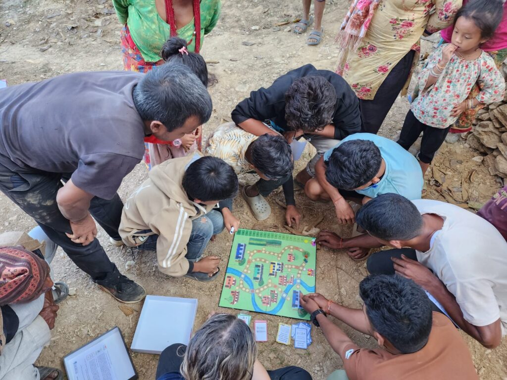
“Bhūkampa! Bhūkampa!” “Earthquake!” the shouts echo around the classroom. “I would have won!” a boy exclaims, begrudgingly sliding his counter back by 5. Students gather around the game board in collective frustration, determined to quickly make up for their lost points. The surrounding valley, however, remains peaceful; we’re sat outside the classroom, basking in the first warm days of the dry season. There is no hint of the earthquake that’s just happened, or the one that may be yet to come.
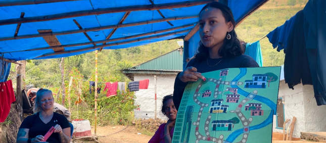
Playing the Disaster Ready! game as part of a community outreach session.
The game itself developed collaboratively, inspired by other so-called “Serious games” used in academic outreach, as well as by larger organisations such as the Red Cross. The underlying principle is to replicate, in some way, a physical or social reality. Through play, the participants learn more about this reality and develop strategies for dealing with the challenges it presents. The Disaster Ready! game aims to encapsulate this as a disaster risk reduction (DRR) education tool – being set within a rural Nepali community, players must move around the village, performing individual and collective actions, as well as acquiring response and recovery cards for when disaster strikes. Actions gain players points and include things such as packing an emergency bag, practicing “drop, cover, hold”, or making a collective emergency plan for their village. Disasters are triggered randomly by landing on red tiles, forcing players to draw a card from the hazard deck containing earthquakes ranging in magnitude from M1-M7.
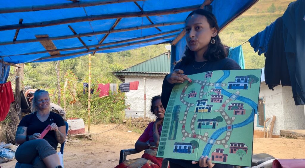
Nirmala explaining the rules of the game in Nepali.
Across all the sessions I delivered during my time in Nepal, the overwhelming response to the Disaster Ready! game was one of curiosity and enthusiasm. Equivalent lecture style presentations on earthquake risk and preparedness, although similar in content, were often met with reserved interest, or polite disinterest. These presentations, me at the front, the audience facing, often felt othering – I was an outsider coming to lecture, not to listen. Playing the game went some way to dissolving these boundaries. The focus switched from my theoretical knowledge, well-intentioned but often naïve in the face of the everyday challenges communities are facing to the experiences of those who live with earthquake risk every day. Shared stories of worry and anxiety, of soup split by ground shaking, of laughter over how many nappies could fit in an emergency bag, replaced what could have been cold and distant knowledge. The game served to humanise the experience of living with earthquake risk and in doing so connected people over their shared realities, generating conversations around what it means to be prepared, both on an individual and community level. The enthusiasm of the children was especially contagious, and the highlight of most sessions was watching their eyes light up as they unpacked the game to begin playing. The Nepali education system, particularly in the most rural areas, is severely underfunded and poorly resourced. Some teachers lack any formal training and most rely on rote learning methods to instil information in their students. Noisy, dilapidated classrooms offer a poor learning environment, and many students struggle to concentrate as a result. This makes learning through a game, like Disaster Ready!, novel and exciting. It is an entirely new approach for many students, encouraging active participation, role play, decision making, and a chance for critical discussion in a system where children’s voices are rarely heard.
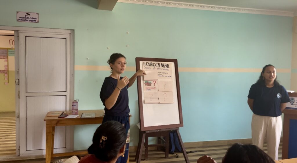
Nirmala and I delivering a session on hazards and preparedness in Nepal. Trialling a lecture-style format for comparison with uptake for the game.
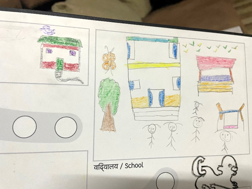
The game was so captivating in part due to its illustrations. These were done by artist Micheal Heap, who’s based at the Leeds Arts University. The initial illustrations were our “best guess” of how to represent a Nepali village. With neither of us having actually been to Nepal before, we based our drawings of houses and schools on those we could find on the internet. Of course, we also knew that this approach would fall short of capturing the vibrancy and life of Nepal, or the cultural cues known only to a native Nepali person. Because of this, we were keen to use Phase I of the trip to understand, artistically, how we could improve the game and embed it within a Nepali context. To do this, I ran a series of workshops with the children whilst in Nepal, encouraging them to draw their houses, villages, and surrounding environment on blank versions of the game boards. What we got back was a wealth of beautiful illustrations – dogs in characteristic Nepali style, flowers, butterflies, adorned temples, rice fields and tractors. These are the images that will bring the game to life.
Some of the children’s drawings. Houses, their school, a butterfly, and a Nepali dog.
Having returned from Nepal, the Disaster Ready! project is now in Phase II – re-development. This includes revising the illustrations on the board and cards based on the student’s drawings. We hope this will more fully capture the context of Nepal and give the students a sense of ownership over the game when it is sent back to them. Connecting with Nepali educators and teachers has also led to invaluable input into the game. This includes revising my attempts at Nepali translations – currently “passable” but overly formal for younger children and, I’m told, with an alarming lack of grammar. Phase II will also see the expansion of the game into other hazards such as wildfires, floods, and landslides. These hazards are felt more frequently than earthquakes by many communities in Nepal but can be just as devasting. The effects of climate change are anticipated to worsen the frequency and severity of these events in Nepal over the next few decades and the country is considered highly vulnerable to climate disasters by the UN.
Building these additional hazards into the Disaster Ready! game is therefore critical to a more holistic approach to community preparedness and risk education. Whilst the challenges of living with the threat of multiple hazards can be many, so too can the opportunities to increase preparedness and resilience to multiple events simultaneously. For example, an emergency bag is useful following an earthquake, but also after a flood, or whilst evacuating due to a wildfire. A community evacuation procedure can be adapted to multiple eventualities and even in its formation may strengthen the sense of collective preparedness and decision-making capacity within the community. This line of thinking can be extended well beyond the traditional disaster risk and preparedness remit. Many communities expressed that their primary vulnerability to disasters such as earthquakes, was in fact their everyday food precarity, lack of access to clean water, and the struggle to survive on incomes well below the poverty line. Asking people to pack non-perishable food in an emergency bag is hardly reasonable when they have insufficient food to eat that evening. In this sense, for many communities, installing a water tank, educating women, or providing agricultural training would do as much for disaster resilience as any DRR-specific actions, whilst simultaneously improving the day-to-day quality of life for many.
The future of the Disaster Ready! game remains somewhat uncertain, caught between ambitions for greater impact and a lack of funding to support our vision. Whilst in Nepal, many students and teachers asked to keep copies of the game, expressing their support for its continued use within their DRR curriculums. The five copies of the game that I took out with me were left for teachers and educators to continue to use, although ultimately, these will have only a very small impact in filling the large void of DRR resources in Nepal. This is where the vision for Phase III of the project comes in – expansion. What if we could print 150 copies of the game, to be distributed to 50 schools in Nepal? What impact could that have? Over 5 years this would translate to 15,000 students having played the Disaster Ready! game. By 2050 – the year that Nepal aims to be “disaster resilient” – over 75,000. These numbers have the potential to make a significant impact, locally, regionally, and maybe even nationally. Crucial to the success of any future phases of this project is of course partnering with and transferring autonomy over the game to local stakeholders. Phase III would therefore be carried out with an in-country partner such as an NGO or academic institution in Nepal, key to monitoring the use of the game over the next few years and evaluating its impact.
One of my final experiences in Nepal was to visit the village of Langtang, situated to the north of Kathmandu and accessible only by helicopter or 3 days of trekking through the jungle. For me, this experience came to represent many of the challenges that persist around delivering DRR education, both in Nepal and globally. But it also inspired me – this work is meaningful, necessary, and should be something that I strive to do throughout my career. The village of Langtang was one of the worst affected by the 2015 Gorkha earthquake, with over 300 casualties due to a landslide which all but wiped out the village. Walking along the hiking path through the valley you pass by what remains, now buried under 20 metres of rubble. My guide, Ram, explained that the landslide happened 30 minutes after the initial earthquake and that ultimately, the actions that people took in those intervening minutes proved critical. Those who were younger, and had generally had more access to education, knew that following the earthquake they should move into open space because of the increased risk of a landslide. These few people survived. But most people in the community, many of whom had never had the chance to engage with any DRR outreach or education, stayed behind. Sheltering in their homes, despite surviving the earthquake, they were left directly in the path of the landslide. The knowledge that saved lives, and that could have saved more if it had only been taught and shared more widely, can fundamentally be reduced down to only two sentences: “Landslide risk is higher following an earthquake. Move to open space and away from steep slopes”.
The remains of Langtang Village buried under the rubble of the landslide following the 2015 earthquake. Only one house, on the right, was left standing.
How many thousands of papers and conference presentations have been produced on the tectonics of the Himalayas? How many field campaigns have drawn on local knowledge and relied on the resources of local communities? And yet, for so many living in this region they did not have the most fundamental, two sentences of knowledge that would have kept them safe. This is in part the result of decades of so-called “helicopter research”, predominantly out of western universities and institutions. If colonial-era science was used to justify the exploitation of resources, then perhaps science under neocolonialism is marked by the extraction of knowledge without a commitment to reciprocity, dialogue, or delivering concrete benefit to communities in whose backyards we are working. This is one of my most lasting impressions – that sharing knowledge, in a way that truly empowers people and communities to understand their environment and to make their own decisions on preparedness and resilience, is fundamental to doing both DRR work and science well. The geoscience community has such a wealth of knowledge and resources, but currently this is struggling to reach the people that need it most. I sincerely hope that projects like Disaster Ready! will contribute to towards bridging this gap.
Want to support the project?
We are currently looking for funding to support Phase III of the project. If you know of suitable funding streams which could be worth applying to please reach out! Or if you have experience of DRR outreach, especially through “serious games” then we would love to collaborate and hear more.
Acknowledgements
A warm thank you to all those who have and continue to support the Disaster Ready! Project: Soroptimist International Leeds, COMET, Volunteers Initiative Nepal (VIN), Dr Claire Quinn, Dr Laura Gregory, Dr Peter Sutoris, Micheal Heap, and Nirmala Karki.
In the geological past, large eruptions have often occurred simultaneously at nearby volcanoes. Now, a team of COMET scientists from the University of Bristol uses satellite imagery to investigate the distances over which restless magmatic plumbing systems interact.
In a study published in the journal Nature Geoscience, the scientists use deformation maps from the Kenyan Rift to monitor pressure changes in a sequence of small magma lenses beneath a single volcano. Importantly, they find that active magma systems were not disturbed beneath neighbouring volcanoes less than 15 km away.
The lead author, Dr Juliet Biggs, explained: “Our satellite data shows that unrest in Kenya was restricted to an individual system. Inter-bedded ash layers at these same volcanoes, however, tell us that they have erupted synchronously in the geological past. This was our first hint to compare observations of lateral interactions based on recent geophysical measurements with those from petrological analyses of much older eruptions.
The team, which includes a recently graduated PhD student Elspeth Robertson and Bristol’s Head of Volcanology Prof. Kathy Cashman, took this opportunity to compare observations from around the world with simple scaling laws based on potential interaction mechanisms. They found that stress changes from very large eruptions could influence volcanoes over distances of up to 50 km, but that smaller pressure changes associated with unrest require a different mechanism to explain the interactions.
Prof Cashman explained ‘Volcanology is undergoing a scientific revolution right now – the concept of a large vat of liquid magma beneath a volcano is being replaced by that of a crystalline mush that contains a network of melt or gas lenses. The interactions patterns observed in Kenya support this view, and help to constrain the geometry and location of individual melt and gas lenses.”
The study was funded by two major NERC projects: COMET, a world-leading research centre focusing on tectonic and volcanic processes using Earth observation techniques; and RiftVolc, which is studying the past, present and future behavior of volcanoes in the East African Rift.
The Society, which has been recognising significant achievements in the Earth sciences since 1831, presented its Wollaston Medal (its highest award, for impacts on pure or applied geology) to COMET’s James Jackson, Professor of Active Tectonics at the University of Cambridge.
Professor Jackson’s work includes research into active tectonics in New Zealand, Iran, Turkey, Greece and Tibet, where he has made vital contributions to understanding the evolution and deformation of the continents, from individual faults to mountain belts.
Professor Geoff Wadge of the University of Reading received the Murchison Medal, awarded to geologists who have contributed significantly to ‘hard’ rock studies. Professor Wadge was recognised for his contributions to geology and remote sensing, including research into volcanology, Caribbean tectonics, and volcanic hazards and risk assessment. The awards were presented by Geological Society President Professor David Manning at their President’s Day on 3 June 2015.
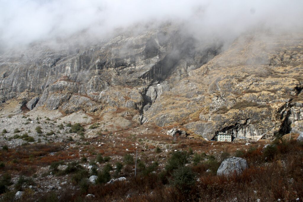
On 22nd April 2015 Calbuco volcano, Chile, erupted for the first time since 1972 with very little warning. Plumes of volcanic ash reached heights of 16 km on the 22nd and up to 17 km in a second, longer eruption that began in the early hours of 23rd April.
Several thousand people were evacuated from villages closest to Calbuco , and ash fell over an area extending from the west coast of Chile to the east coast of Argentina, and grounded air traffic in Chile, Uruguay and Argentina.
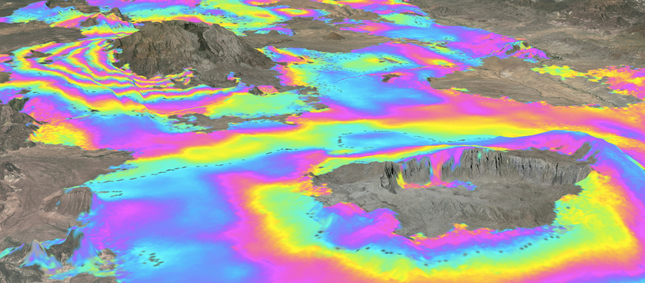
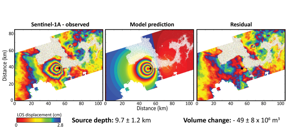
COMET scientists have been using satellite data to analyse the event, in terms of both the emissions and changes to the shape of the volcano itself. You can read more about the event here.
Data, spherical source elastic half space model and residuals for recent deformation at Calbuco [Bagnardi].
COMET Director Tim Wright has been selected as the 2015 Rosentiel Award Recipient by the University of Miami (UM) in recognition of his research into deformation of the Earth’s crust in response to tectonic forces.
The Rosenstiel Award honours scientists who, in the past decade, have made significant and growing impacts in their field. Tim’s major achievements include the discovery of a continental rifting event in Ethiopia’s Afar region, one of the few places on Earth where a mid-ocean ridge comes ashore.
He was also one of the first scientists to measure how plate boundary zones deform, solely relying on satellite observations using a technique called satellite radar interferometry.
Tim presented the 2015 Rosenstiel Award Lecture, “Witnessing the Birth of Africa’s New Ocean” at the UM Rosenstiel School auditorium on Friday 3rd April 2015.
Christoph Gruetzner reports from the meeting here.
Manage Consent
To provide the best experiences, we use technologies like cookies to store and/or access device information. Consenting to these technologies will allow us to process data such as browsing behavior or unique IDs on this site. Not consenting or withdrawing consent, may adversely affect certain features and functions.
Functional
Always active
The technical storage or access is strictly necessary for the legitimate purpose of enabling the use of a specific service explicitly requested by the subscriber or user, or for the sole purpose of carrying out the transmission of a communication over an electronic communications network.
Preferences
The technical storage or access is necessary for the legitimate purpose of storing preferences that are not requested by the subscriber or user.
Statistics
The technical storage or access that is used exclusively for statistical purposes.The technical storage or access that is used exclusively for anonymous statistical purposes. Without a subpoena, voluntary compliance on the part of your Internet Service Provider, or additional records from a third party, information stored or retrieved for this purpose alone cannot usually be used to identify you.
Marketing
The technical storage or access is required to create user profiles to send advertising, or to track the user on a website or across several websites for similar marketing purposes.