All posts by COMET2014

Celebrating Excellence in Earth Sciences: Two COMET Scientists Elected Fellows of the Royal Society

We are delighted to celebrate COMET Scientists Professor Marie Edmonds (University of Cambridge) and Professor David Pyle (University of Oxford), who are amongst the outstanding and distinguished group of scientists elected Fellows of the Royal Society this year. This prestigious title is awarded to scientists who have made exceptional contributions to science, and the ground-breaking work that both professors have undertaken throughout their careers is certainly deserving of this honour.

Professor Marie Edmonds FRS – University of Cambridge

Professor Marie Edmonds is an Earth Scientist whose interdisciplinary research spans volcanology, igneous petrology, tectonics, atmospheric science and economic geology. Her work focuses on understanding how certain elements move through the Earth system – elements that are essential for creating a habitable planet, powering volcanic eruptions, and concentrating valuable metals in the Earth’s crust.

Professor Edmonds has significantly advanced our understanding of how volcanoes work and their broader impacts on our planet. She has developed new ways to monitor volcanoes by studying the gases they release, helping scientists better predict when eruptions might occur and assess the risks they pose to nearby communities. Her research has also revealed how carbon moves through the Earth over millions of years, providing vital insights into long-term climate change. She has shown how hot, mineral-rich fluids from deep within the Earth create the metal deposits we rely on for modern technology, and has reconstructed huge ancient eruptions to understand how they altered Earth’s climate and environment in the past.

As Professor of Volcanology and Petrology and Head of the Earth Sciences department at the University of Cambridge, Professor Edmonds also serves as the Ron Oxburgh Fellow and Vice President of Queens’ College, Cambridge. Her excellence has also been recognised through membership of the Academia Europaea and the American Geophysical Union College of Fellows.

Professor David Pyle FRS – University of Oxford

Professor David Pyle’s fascination with volcanoes began early; he saw his first volcano at age seven in Chile, sparking a lifelong interest that would shape his distinguished career. After studying geological sciences at the University of Cambridge and completing his PhD on the volcanic histories of Santorini, Greece, and Oldoinyo Lengai, Tanzania, he has dedicated his research to quantifying the scale of volcanic eruptions and understanding their processes and impacts.

As Professor of Earth Sciences at the University of Oxford, Professor Pyle’s research combines geological fieldwork with archival records to build comprehensive pictures of volcanic activity. His work includes creating detailed eruptive histories of individual volcanoes to global-scale analyses, encompassing young and active volcanoes on Earth as well as investigations relevant to the early Earth and other planetary bodies. This broad perspective has contributed significantly to our understanding of volcanism across space and time.

Beyond his research excellence, Professor Pyle has demonstrated exceptional commitment to outreach and public engagement with science. He curated the ‘Volcanoes’ exhibition at the Bodleian Library, Oxford in 2017, authored two books, and helped lead two Royal Society Summer Science exhibits: ‘Fast and Furious’ in 2010 and ‘Sensing Volcanoes’ in 2023. His contributions to the field were recognised with the prestigious Murchison Medal of the Geological Society of London in 2024.

A Celebration of Earth Sciences Excellence

The election of both Professor Edmonds and Professor Pyle as Fellows of the Royal Society represents a tremendous achievement for Earth sciences, highlighting the vital importance of understanding our planet’s dynamic processes. Their complementary expertise demonstrates the breadth and depth of excellence in volcanic research.

We extend our warmest congratulations to Professor Marie Edmonds FRS and Professor David Pyle FRS on this prestigious honour!


Myanmar Earthquakes, March 2025

On 28th March 2025, a 7.7-magnitude earthquake struck Myanmar, affecting large areas of the country and causing widespread destruction. A powerful 6.4-magnitude aftershock followed 12 minutes later, approximately 31 kilometres south of the initial shaking. The country, and surrounding areas, were also subjected to hundreds of smaller aftershocks for weeks after the initial event. Myanmar’s military government have estimated that the death toll has surpassed 3,000 people and an additional 4,500 have suffered injuries. The shallow depth of the earthquake (~10km) caused violent ground shaking and extensive damage to local buildings and infrastructure.

Data from ESA’s Sentinel-1 satellite first captured on 29th March clearly show the physical effects of the earthquake on the region. The earthquake ruptured a remarkably long and simple fault, around 500 km in total length, with a relative motion across the fault of up to around 6 m (west side to the north, east side to the south). Although most of the motion is horizontal, there is also a vertical offset of around 1 m across the fault (east side down).

One of Myanmar’s largest cities, Mandalay, sits close to this extensive ground movement (at around 22°N), explaining the significant human and structural impact of the event.

By combining Sentinel-1 imagery from before and after the earthquake, COMET scientists have been able to measure surface deformation that is clearly visible in the data sets shown below:Figure 1: Data from four Sentinel-1 tracks (2 ascending and 2 descending), each consisting of three standard LiCSAR frames (~13 bursts per subswath), were used to cover the deformation zone. Azimuth offsets (top panels) capture along-track (north–south) deformation. Range offsets (bottom panels) represent Line-of-Sight (LoS) deformation. Burst Overlap Interferometry (right) provide high-resolution along-track deformation. Red indicates southward, and blue indicates northward motion.

Figure 2: 3D co-seismic displacement fields and associated uncertainties were estimated using a Weighted Least Squares approach applied to the offset tracking datasets. Red colors represent east, north, and up directions, respectively. Only pixels with sufficient multi-geometry observations were used

The processing outputs from Sentinel-1 data are available for download at our LiCSAR system event page.

All related datasets and figures can be accessed here.

The images above contain modified Copernicus Sentinel-1 data analysed by the UK Centre for the Observation and Modelling of Earthquakes, Volcanoes and Tectonics (COMET). Data processing uses JASMIN, the UK’s collaborative data analysis environment (http://jasmin.ac.uk).

For more information on why and how COMET responds to earthquake events read this article by COMET Co-Director, Professor Tim Wright.

Analysis and figures produced by COMET Postdoc Dr Milan Lazecky and PhD student Muhammet Nergizci.

COMET – 17th April 2025


Professor David Pyle awarded Geological Society Murchison Medal

COMET Scientist Professor David Pyle (University of Oxford) is the recipient of the 2024 Murchison Medal, awarded by the Geological Society of London for his considerable contributions to the field of volcanology.

The Murchison Medal is awarded to geologists who have contributed significantly to ‘hard’ rock studies.  David is an internationally recognised volcanologist who has made outstanding contributions to understanding volcanic deposits and processes, using pioneering methods to characterise and classify tephra fall deposits and infer erupted volumes.

The Geological Society will host a formal awards ceremony on 12 June with more details of the day to be shared via its magazine Geoscientist, website and social media channels.

Congratulations David from all of your colleagues at COMET!

Observations and models of Icelandic eruption lead to new understanding of volcanic systems

In November 2023, a state of emergency was suddenly declared in a fishing town in Iceland, Grindavík, and all residents were rapidly evacuated. In the space of around 6 hours, escalating seismic activity was felt: large cracks and fault movements occurred at the earth’s surface, and homes, businesses and infrastructure were destroyed.

This devastation was caused by huge amounts of magma moving at an unprecedented speed below the surface, which rushed into a crack that opened up below the town. The intrusion that formed was approximately 15-kilometres-long and extended around 1-5 km deep, with widening of up to 8 meters.

The processes and timescales behind the formation of major cracks, or “dikes”, aren’t currently fully understood but the international team of researchers behind a paper published in Science today have revealed new findings that shed some light on how these hazardous events occur.

Using detailed satellite observations alongside seismic measurements and physical modelling, the team of investigators led by University of Iceland and the Icelandic Meteorological Office, found that the magma flow rate under the surface of the earth reached an ultra-rapid and previously unrecorded speed of 7400 cubic meters per second. The study also shows that huge amounts of magma can be forced into cracks due to fracturing in the earth and tectonic stress, without much pressure coming from underlying magma source that feeds it. These findings demonstrate a significant hazard potential for this volcanic system and others with similar features, which can result in large-volume magmatic eruptions on the surface.


COMET Scientist, Professor Andy Hooper, was a key member of the team of investigators:

“Nothing like these rates of magma flow have ever been measured before. Luckily, the magma did not make it to the surface at that time, but this helps us understand how magma-filled cracks that are tens of kilometres long may have formed in the past.”


The events in November were the beginning of the activity in the affected area around Grindavík. Smaller magma intrusions occurred in December 2023 and January 2024, which unfortunately culminated in large eruptions and further devastation in the town, and a new, ongoing eruption started this morning (February 8th 2024).

Publication available here (open access for all for two weeks): https://www.science.org/doi/10.1126/science.adn2838

COMET Internship Experience

Project Title: Improving Building Exposure Datasets using High-Res Imagery and Deep Learning 

Supervisors: Dr. Scott Watson and Dr. John Elliott (University of Leeds) 

Name of Intern student: Francesca (Frankie) Butler 

Bio: Final Year Undergraduate at the University of Aberdeen, reading Geology and Petroleum Geology, with a specific interest in pursuing a PhD in Volcanology, Magma Mixing.  

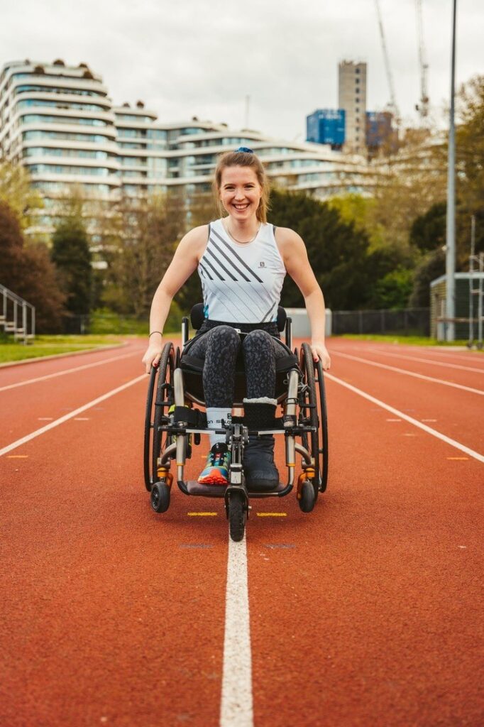
Following a life changing injury, I have had to look deeper at remote Geology, attend virtual field trips, GIS Mapping and most recently, the new frontier of Deep Learning in GIS.  

I am also interested in science communication, and I am part of the Geoscience academic community on Twitter – @frankiealoise I enjoy presenting ideas/research and documenting my journey as a disabled geologist, both in the field and the lab. 

I thoroughly enjoyed the COMET internship as it gave me the opportunity to learn new skills and speak at the annual student COMET meeting, combining PhD style research with Science communication and remote Geology/ Geoscience work! 

Project:  

Project title: ‘Improving Building Exposure Datasets using High-res Imagery and Deep Learning’  

Testing the application of a variety of deep learning models to an area of Kathmandu and assessing transferability and improvements 

Independent 6-week summer research project, fully funded by NERC, COMET and the University of Leeds. 

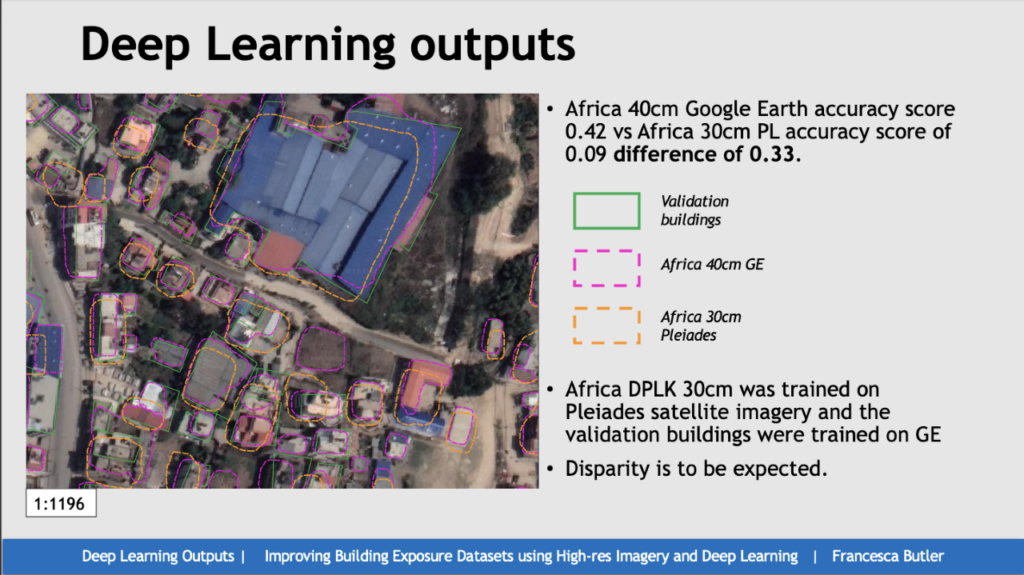
Manually mapping buildings in Kathmandu, Nepal from high resolution satellite imagery. Using QGIS and ARCGIS to draw polygonal outlines around buildings.  

These manually collected outlines were then used to train Deep Learning Models to identify buildings with the end goal to create a pre-trained Deep Learning model for Kathmandu. Investigated the use of Non-Differentiated Vegetation Index (NDVI) masks to improve the accuracy assessment score and improve the overall accuracy of the model.  

These deep learning models are important for mapping building footprints quickly. Kathmandu currently has no established model and this will help to inform future planning and humanitarian response following natural disasters. 

Outputs: 

Partially trained Deep Learning Models for Kathmandu.  

Accuracy Assessment Scores for Pre-trained deep learning models.  

Helped to define a direction for future research for my Supervisor Dr Scott Watson; the use of Non-Differentiated Vegetation Index (NDVI). 

15 Minute presentation at the NERC COMET student meeting in person in Manchester (January 15th 2023) 

The overall experience: 

I thoroughly enjoyed the NERC summer internship programme.  

I learnt so much about the process and approach you must have to research projects. 

I felt I was learning and contributing to research at the forefront of the field. 

Deep Learning programmes are becoming more prevalent within Geoscience, the work I did with Scott has helped me throughout my current Geology degree. I have attended PhD and Post-Doc talks on Deep Learning, and I understood their approach and felt I could ask relevant questions. 

Scott was an excellent supervisor, I had enough free reign to investigate areas I felt 

needed investigating, but I also had enough guidance. I felt I could ask any questions without fear of retribution. 

I learnt how to use some incredibly useful programmes that I am integrating into my own research. 

It was interesting as the project was within an area of geoscience that I am not wholly comfortable with- coding and new programmes. But the process of learning how to use them, making mistakes and learning how to rectify them, was really important for my overall development as a scientist. 

This project has helped to solidify that I would like to pursue a PhD in Geology. 

I completed this project whilst recovering from a serious life-changing injury. The understanding and compassion from all staff members allowed me to complete the work to a high standard whilst not jeopardising my recovery.  

I truly enjoyed the experience, thank you to Leeds and NERC for this experience! 

PhD Webinars

Thinking of applying for a PhD?

Watch again a webinar, supported by COMET, where SENSE CDT and their panelists discuss how to apply for PhDs:

Are you thinking of doing a PhD? Not sure what the benefits might be to you or your career?

Join us and our wonderful panelists to hear about their experiences doing a PhD and how they feel it helped them, the skills that they gained, and how it got them into the exciting jobs they do today. The panelists PhDs were all in environmental science and many specialised in using satellite data – Earth Observation.


Professor Gregory Houseman honoured with Fellowship of the Royal Society

Professor Gregory (Greg) Houseman, Emeritus Professor of Geophysics at the University of Leeds and Emeritus COMET Scientist, is amongst the outstanding and distinguished group of scientists who have been elected Fellows of the Royal Society this year 

This prestigious title is awarded to scientists who have made an exceptional contribution to science and Professor Houseman’s work is certainly deserving of this honour.  

Professor Houseman’s research has produced very significant and long-standing advances in geodynamics,  which clearly explain the relationship between the governing equations, their critical parameters and surface measurements.  His contributions to the field include showing how convective instabilities link convection and continental dynamics, testing predictions of density structure associated with lower lithosphere removal, and further demonstrating the relationship between the width and length of mountain belts.  Irecent years, his research has focused on developing new understanding of key geological problems in the deformation of the Earth’s crust and lithosphere through computer modelling of geological deformation, and using seismic arrays, natural earthquakes and seismic noise to map the 3-D structure of the lithosphere and upper mantle in tectonically active regions like Turkey and Eastern Europe 

Professor Houseman’s work demonstrates that when a continent thickens as tectonic plates converge, convective instabilities can remove the lower lithosphere. This increases the gravitational potential energy of the overlying continent, leading to changes in surface height, volcanism and deformation. This process is now recognised as a fundamental influence on geological activity.  By combining satellite observations of ground movement with numerical models at locations including the North Anatolian Fault in Turkey, he has also developed an improved understanding of the earthquake deformation cycle, which is leading towards a better assessment of future seismic hazard.  

The many honours bestowed on Professor Houseman for his important contributions to the field include the European Geophysical Union’s Augustus Love Medal (2015) and Fellowship of the American Geophysical Union (2001), where he was also elected Section President for Tectonophysics (2004-2006).  He has been a Fellow of the Institute of Physics since 2004, held a CIRES Fellowship at the University of Colorado at Boulder (2015) and was elected to Academia Europaea in 2016. 

COMET would like to congratulate Professor Houseman on receiving his Fellowship of the Royal Society! 

COMET-BGS Studentship 2021

***This studentship is fully funded for UK students through COMET and the BGS***

Project Title: The dynamics of dip-slip faulting across multiple timescales

 Supervisory Team:

  • Dr Tim Craig (University of Leeds – Primary Supervisor)
  • Dr Ekbal Hussain (British Geological Survey)
  • Prof. Tim Wright (University of Leeds)
  • Dr Alex Copley (University of Cambridge)
  • Dr Laura Gregory (University of Leeds)

Host Institution: University of Leeds, UK.

Deadline: Applications will close on Thursday 22nd April 2021

Figure 1: Exposed fault surface of a active normal fault in Western Anatolia.

Project Summary:

This project aims to understand the factors that control the behaviour of dip-slip faults across a range of timescales, from individual stages of earthquake cycles, to their geological evolution over millions of years. This project will draw on a wealth of new geological and geophysical observations and data, and produce new numerical geodynamic models aimed at understanding the evolution and behaviour of dip-slip faults.

 The initial aim for this project will be to analyse geodetic (GPS, InSAR) data to determine the surface motions before, during, and after dip-slip earthquakes. We will then develop models that will allow us to use the observations to infer the rheology and dynamics of the brittle and ductile parts of the crust, using realistic structural and rheological parameters for the fault zone. Of particular interest is how the brittle (and potentially seismogenic) portion of the fault interacts with ductile shear zones at depth, how this interaction controls the geometry and rate of deformation at the timescale of individual earthquake cycles, and how this behaviour ultimately governs the longer-term geological evolution of the fault system and the bounding basins and mountain ranges. An underlying aim of the project will be to use this work to establish how to estimate the pattern of interseismic strain accumulation on active dip-slip fault systems, as a means to improving our understanding of the hazard posed by these faults.

As the project is aimed at understanding globally-applicable concepts, it is geographically unconstrained, but initial target fault systems of interest may include the active fault systems of western United States, eastern Africa, Greece, Italy, Papua New Guinea, and western Anatolia. The initial project is not planned to involve fieldwork, we expect there to be opportunities to participate in fieldwork on related projects in later years.

This initial work coupling geodetic observations to dynamic models of earthquake cycles will not only answer a number of fundamental scientific questions, but will also provide the opportunity for the student to develop relevant observational techniques and skills in numerical geodynamic modelling. Following this initial work, a number of avenues exist to focus on in the later years of the project, depending on the interests and skillset of the student and the nature of the initial results. These include, but are not limited to:

  • Modelling the evolution of large-offset normal faults, and the impact that increasing footwall erosion and hangingwall sedimentation have on the dynamics of the system, and how this development of the fault system feeds into the longer-term landscape and geological structure.
  • Constraining the along-strike segmentation of normal fault arrays, and how this may be controlled by shear-zone geometries at depth.
  • Comparative studies investigating how varying crustal architecture and composition influence the rheological structure of the fault system, and how this impacts on the deformation patterns seen.
  • Investigating the across-strike migration and transfer of strain amongst dip-slip fault arrays, where multiple faults are active at once.
  • Modelling the rheological evolution of large-offset detachment faults, and how this impacts their earthquake behaviour.
  • Should a major dip-slip earthquake of particular interest occur during the duration of the studentship, the student may have the opportunity to work on the scientific response to this event as part of the COMET team.
  • Performing determinisitic or probabilistic hazard assessments for dip-slip faults, based upon our new results regarding the dynamic controls on their behaviour.

References:

  • Craig and Parnell-Turner (2017). Depth-varying seismogenesis on an oceanic detachment fault at 13o20’N on the Mid-Atlantic Ridge, EPSL, v479, pp60-70.
  • Copley et al., (2018). Unexpected earthquake hazard revealed by Holocene rupture on the Kenchreai Fault (central Greece): implications for weak sub-fault shear zones. EPSL, v486, pp141-154.
  • Biemiller et al., (2020). Mechanical implications of creep and partial coupling on the worlds fastest slipping low-angle normal fault in southeastern Papua New Guinea, JGR, v125, doi:10.1029/2020JB020117.
  • Hussain et al, (2020). Contrasting seismic risk for Santiago, Chile, from near-field and distant earthquake sources, Natural Hazards and Earth System Sciences, v20, pp1533-1555.
  • Walters et al., (2018). Dual control of fault intersections on stop-start rupture in the 2016 Central Italy seismic sequence. EPSL, v500, doi: 10.1016/j.epsl.2018.07.043.
  • Weiss et al., (2020). High-resolution surface velocities and strain for Anatolia from Sentinel-1 InSAR and GNSS data. GRL, v47, pp:e2020GL087376.

Training: The student will work primarily in Leeds under the supervision of Dr Tim Craig, Prof. Tim Wright, and Dr Laura Gregory within the Institute for Geophysics and Tectonics. Regular collaboration with Dr Alex Copley and Dr Ekbal Hussain will be facilitated remotely and by regular visits to the partner institutions, with an expectation that the student would spend longer periods of time at the BGS in Keyworth and in Cambridge as the project requires. The student will receive training in satellite geodesy, observational earthquake seismology and numerical geodynamic modelling. The student will benefit from networking and training available through the NERC-funded Centre for the Observation and Modelling of Earthquakes and Tectonics (www.comet.nerc.ac.uk), with whom the student will be able to interact. Within Leeds, they will have the opportunity to interact with internationally-excellent research groups in Tectonics and Structural Geology, hosted within the Institute for Geophysics and Tectonics.

Applicant Background: This project would suit candidates with a background in quantitative geology, geophysics, or physics with an interest in solid-Earth processes. Prior skills in computer programming, observational geodesy, seismology or numerical geodynamic modelling are desirable, but not required.

To apply: For further information, and to discuss the project and applications, please contact t.j.craig@leeds.ac.uk, and include your current CV.

Free Public Lecture, 25th September – Monitoring our hazardous planet from space

COMET Director Professor Tim Wright  will present a free public lecture, ‘Monitoring our hazardous planet from space’, as part of the Royal Astronomical Society’s Bicentenary celebrations

Fri, 25 September 2020
13:00 – 14:00 BST

Register to attend here

This lecture is part of the free and open to the public lecture series for the Royal Astronomical Society’s bicentenary celebrations and will take place online.

In the last twenty years, earthquakes have caused the deaths of nearly 1 million people and volcanic activity has resulted in hundreds of thousands of people being evacuated from their homes. These events also cause major economic disruption, with aftereffects ranging from the destruction of buildings and infrastructure to airspace closures. Scientists in COMET* are at the forefront of international efforts to monitor our hazardous planet using satellites. COMET scientists are now providing critical information to decision makers around the world so that they can prepare for and quickly respond to earthquakes and eruptions. In this lecture, I will show how satellites are used to monitor tiny ground movements with extraordinary accuracy and explain how understanding these movements can help us forecast where future earthquakes will occur and when volcanoes might erupt.

*COMET is the UK Natural Environment Research Council’s Centre for the Observation and Modelling of Earthquakes, Volcanoes and Tectonics.

Main Event image: A building that collapsed during the January 2020 Turkey earthquake, which occurred in one of the high strain zones. Photo courtesy Roger Bilham, University of Colorado.

About the speaker:

Tim Wright is Professor of Satellite Geodesy at the University of Leeds and Director of COMET. His work has been at the forefront of developing the use of satellite radar for measuring tectonic and volcanic deformation. He was the first to measure the slow accumulation of tectonic strain around active faults with satellite radar, and he is currently leading a major project using the latest satellites to map how all the continents are deforming. In 2018 he co-founded a spinout company, Satsense Ltd, which is monitoring ground movement in the UK at high resolution. Tim has received several awards for his work including the 2014 Geodesy Section Award from the American Geophysical Union, the 2015 Bullerwell Lectureship from the British Geophysical Association, and the 2017 Harold Jeffreys Lectureship from the Royal Astronomical Society. In 2018, COMET was awarded the Royal Astronomical Society’s Group Achievement award in Geophysics.