Dramatic data from last year’s major earthquake in Kaikoura, New Zealand, will change the way scientists think about earthquake hazards in tectonic plate boundary zones.
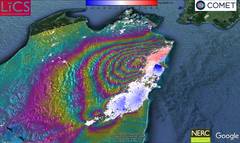
The South Island earthquake was one of the most comprehensively recorded earthquakes in history. Satellite images of the earthquake and its aftermath have enabled scientists to analyse the quake in an unprecedented level of detail.
COMET Director Tim Wright, study co-author, said: “We’ve never seen anything like the Kaikoura quake before, it was one of the most complex ever recorded.
“An earthquake commonly ruptures across a single fault line or faults that are closely grouped; Kaikoura ruptured at least 12 major faults. This challenges many assumptions about how individual faults control earthquake ruptures.”
Immediately following the start of Kaikoura’s earthquake in November, the Sentinel-1 and ALOS-2 satellites were tasked with gathering images and data. COMET researchers at the University of Leeds used the data to provide a rapid analysis of what was happening during the quake.
They found that seismic readings of the earthquake were not giving accurate assessments of where the ruptures were occurring.
Professor Wright said: “Seismic readings are currently the fastest method of gathering earthquake data as they can quickly read shockwaves sent through the earth – but they paint a crude picture. The complexity of the Kaikoura earthquake caused seismologists to completely misinterpret the earthquake based on these seismic waves.
“Satellites such as the European Space Agency’s Sentinel-1 measure the way the ground deforms at very high resolution. The detail in the images showed us that ruptures took place across many separate faults.
“One of the aims of COMET is to expand satellite capability to provide rapid response earthquake data to ensure residents and rescue workers have access to fast and accurate information.”
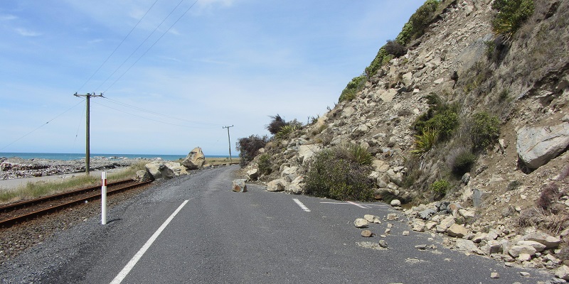
The satellites provided pre- and post-earthquake images to measure the extent of land movement. Kaikaoura’s earthquake caused sections of earth to move up to 25 metres and created surface ruptures measuring 12 metres. This caused large scale landslides and triggered a tsunami.
In a study published today in Science, the team of researchers reports the full range of data analysed from Kaikaoura’s earthquake, including satellite imagery, field observation, GPS data and coastal uplift data.