Pablo Gonzalez’s work on the 2014 Pico do Fogo eruption has been featured in the AGU’s Eos magazine.
Pico do Fogo. Credit: Nicole Richter
The research uses a new satellite imaging system to model the subsurface path of the magma that fed the eruption, and shows that Sentinel-1’s TOPS InSAR technique has the potential to be used to study other natural hazards, including earthquakes and landslides.
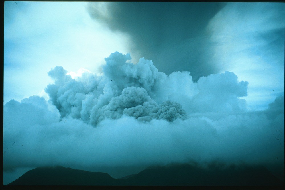
Scientists from COMET are participating in a workshop, funded by the US National Science Foundation, to study Santiaguito volcano, Guatemala.
SUAS shot of an explosion at Santiaguito volcano, January 9 2016
Matt Watson, Luke Western and Kate Wilkins have been in Guatemala since January 2nd, acquiring data with a range of instruments including three UV camera systems, three additional mini-UV spectrometers, a multispectral infrared camera, a lightweight infrared camera and a Phantom II Small Unmanned Aerial System (SUAS).
<a href="http://tempcomet.leeds.ac site acheter viagra.uk/wp-content/uploads/2016/01/guatemala1.jpg”>SUAS selfie showing an array of IR and UV cameras
The meeting, the first in a series of scientific and educational workshops to be held at an active laboratory volcano every two to three years, is lead by a selection of principal scientists who have different field-based data collection expertise.
They, along with students and local scientists, conducted fieldwork just prior to the formal workshop. During the main phase of the workshop additional participants, including other students and professionals, arrived and had an opportunity to both observe the field installations and participate in data collection.
Formal lectures, on both measurement techniques and recent findings on shallow conduit processes at Santiaguito, were given by the principal scientists on January 5th. Different groups then headed out for four days to make various observations and measurements of the volcano.
The focus for the following two days, the last of the workshop, was on breakout groups and hands‐on analysis of the multiple data types that were collected concurrently. Everyone participating in the workshop, including students and principal scientists, shared and received all the data products at the end of the workshop.
Following the workshop, analytical results, tools, and integrated products will be delivered to the participants and published electronically for the broader community.
Watson, Western and Wilkins, with Helen Thomas from Nicarnica Aviation, are now heading to both Pacaya and Fuego volcanoes. At Pacaya they hope to undertake a drone survey of the crater by adapting the Phantom II to fly the lightweight IR camera. At Fuego, they will acquire more imaging and spectral measurements of the volcano’s emissions and investigate installation of the multispectral infrared camera.
On the evening of December 2 2015, Sicily’s Mount Etna began to erupt for the first time in over two years, reaching a brief but violent climax in the early hours of December 3 which included lava fountains as well as a column of gas and ash several kilometres high. The event was among the most violent seen at Etna over the last twenty years.
Ash cloud from Mount Etna’s Voragine crater lights up the sky. Credit: Marco Restivo/Demotix/Corbis
Luckily, good weather meant that the eruption could be monitored with visual and thermal cameras from the Istituto Nazionale di Geofisica e Vulcanologia (INGV) Etna Observatory. According to INGV reports, activity peaked between 02:20 and 03:10 GMT when a continuous lava fountain reached heights well above 1km; with some jets of volcanic material reaching 3km into the sky. Although the eruption had more or less ceased by dawn, the volcanic cloud had blown northeast, causing ash to be deposited on the nearby towns of Taormina, Milazzo, Messina and Reggio Calabria.
The eruption has so far continued, repeating the behaviour seen earlier with tall lava fountains and eruption columns many kilometers high. Updates can be found on the INGV webpage.
COMET scientists at the University of Oxford have been tracking the volcanic plume’s progress using data from the Infrared Atmospheric Sounding Instruments (IASI) on board ESA’s MetOp-A and MetOp-B satellite platforms. These instruments can detect the presence of volcanic SO2 in the atmosphere, using methods developed by the University’s Earth Observation Data Group.
The results, which can be found on the IASI NRT web page, showed that by Friday 4 December the plume had reached an area between Crete and Iraq, containing 0.06 Tg (1012g) SO2.
Estimate of SO2 amount from IASI-A overpass on the morning of 3 and 4 December 2015, assuming the SO2 between 9 and 10 km altitude
By the morning of 7 December, the plume had travelled from Sicily to Asia, reaching as far as Japan and the Pacific Ocean.
Screenshot from IASI NRT webpage 7 December 2015
Dr Elisa Carboni, a COMET researcher based at the University of Oxford, said: “This is a great example of how we can track volcanic plume using the near real time IASI service. ”
Are the volcanoes of the Ethiopian Rift Valley now peaceful, or do they continue to pose a threat to the tens of millions of people who live and work the land across this vast region?
View into the Main Ethiopian Rift Valley, on the descent from Butajira to Ziway. Aluto volcano in the centre distance.
Read COMET scientist David Pyle’s blog post on the work of the NERC-funded RiftVolc consortium, which is carrying out a broad-scale investigation of the past eruptive histories, present status and potential for future activity of the volcanoes of the Central Main Ethiopian Rift.
Around 20 scientists gathered at the University of Leeds recently to share their knowledge and their views on how magmatic activity can be understood and reproduced by models of volcanic processes.
Fourteen COMET members, including scientists, research staff and students, were joined by experts in various fields of volcanology from other world-leading institutions such as the United States Geological Survey, the University of Geneva and the University of Liverpool.
At the workshop we discussed the numerous challenges we face when we try to experimentally replicate natural processes such as those occurring at volcanoes. The most important limitation is that we can exclusively witness and measure what happens at the surface of the volcanoes, and only indirectly infer what goes on beneath them.
There are many different techniques commonly used to take the pulse of the magmatic activity: we measure how the volcanic edifices deform, we record seismic waves coming from and travelling through the magmatic systems, we collect and analyse lava and ash samples during eruptions, we measure the concentration of gases emitted by volcanic vents etc.
The rapid expansion and improvement of satellite Earth Observation (EO) techniques (such as radar interferometry to measure deformation, infrared atmospheric sounding to measure gas emissions etc.) offers further opportunities to study magmatic processes at a global scale.
Although each technique can shed light on one or more volcanic processes, the highest chance of truly understanding what controls the magmatic activity happens when all the measurements and information are analysed together.
The use of a multi-disciplinary approach was the key element of the COMET workshop and all participants agreed that future research in volcanology must move in this direction. Conceptual and numerical models of how magma is stored beneath the surface must be able to reconcile the observed deformation, the amount of gasses released in the atmosphere and the physical/chemical properties of the erupted products. Models of how magma reaches the surface during eruptions need to explain the seismic signature of magma ascent, be compatible with the mechanical properties of volcanic rocks, and consider magma as a multi-phase fluid containing gas, liquid and crystals.
During our workshop, we identified several potential research projects that will be developed in the coming months and that will imply the use of information from different disciplines of volcanology. For example, we aim to globally classify active volcanoes on the basis of their behaviours in terms of deformation and gas emissions. Much effort will also be put in understanding the characteristics of magma reservoirs, moving from conceptual models of simple liquid-filled cavities to complex, multi-phase, dynamic systems.
Finally, specific volcanoes where COMET scientists already have access to long records of geophysical, geochemical and petrological data (for example Soufriere Hills Volcano in Montserrat or Kilauea Volcano in Hawaii) will be used as natural laboratories. At these locations, we will test models that try to reproduce processes ranging from specific eruptive behaviours to long-term magma supply to the volcanoes.
For further information, contact Dr Marco Bagnardi m.bagnardi@leeds.ac.uk.
COMET researchers have used the European Space Agency’s Sentinel-1A satellite to shed light on the 2014-15 eruption at Fogo, the most active volcano in the Cape Verde archipelago.
Their paper, published in Geophysical Research Letters, investigates the eruption using Sentinel-1A’s new radar acquisition mode, Terrain Observation by Progressive Scans (TOPS).
Fogo has erupted at least 26 times in the last 500 years, and this particular event lasted 81 days from November 2014 to February 2015. It had devastating consequences for the island. Fast lava flows destroyed the villages of Portela and Bangaeria in early December 2014.
As the satellite had only been operating for a few weeks when the eruption began, this is the first study to use Sentinel-1A TOPS to investigate surface deformation associated with volcanic activity.
Lead author Dr Pablo J. González, from the University of Leeds, explained: “the study has given us a real insight into the inner workings of Fogo volcano. It also shows the potential of Sentinel-1’s TOPS mode for monitoring volcanic activity in the future acheter du viagra.”
Up until recently, the volcano had mostly been monitored by a GPS network with limited spatial coverage. In comparison, the wide area and high spatial resolution of Sentinel-1A’s satellite images allowed the team, which included researchers from Norway, The Netherlands and Canada, to monitor ground deformation across Fogo.
Using the TOPS data, they found that during the eruption the ground surface had changed in a “butterfly” shape, characteristic for a dike intrusion (where the magma intrudes into a fissure, shouldering aside other the existing layers of rock).
Sentinel-1A ascending interferogram spanning the onset of the2014-2015 Fogo eruption (3 – 27 November 2014). Each colour fringe represents ~3 cm of ground displacement.
Models created to reproduce the observed data then showed that first of all the magma moved rapidly from depths of more than ten kilometres below the volcano’s summit. It then moved along the dike to feed the eruption at a fissure on the southwestern flank of the volcano’s summit cone, rather than from its top.
This was backed up by the satellite data showing a lack of deformation across the whole island during the eruption, which would have suggested that it was instead being fed by an inflating/deflating magma reservoir directly beneath.
The findings will now set the direction for further research aimed at understanding the pattern of eruptions on the island, as well as assessing the stability of the entire volcanic structure.
Dr Marco Bagnardi, COMET researcher, and also co-author in this paper, added: “Our results not only show the importance of near-real time ground deformation monitoring at Fogo, they also demonstrate the potential of Sentinel-1A’s TOPS mode for monitoring geohazards more widely.”
A huge volcanic eruption in Iceland emitted on average three times as much of a toxic gas as all European industry combined, a new study has revealed.
Bárðarbunga eruption. Credit: John Stevenson.
Discharge of lava from the eruption at Bárðarbunga volcano, starting in August 2014, released a huge mass – up to 120,000 tonnes per day – of sulphur dioxide gas. You can watch a video of the eruption here.
These emissions can cause acid rain and respiratory problems.
Dr Anja Schmidt, a COMET Associate from the School of Earth and Environment at the University of Leeds, who led the study, said: “The eruption discharged lava at a rate of more than 200 cubic metres per second, which is equivalent to filling five Olympic-sized swimming pools in a minute. Six months later, when the eruption ended, it had produced enough lava to cover an area the size of Manhattan.
“In the study, we were concerned with the quantity of sulphur dioxide emissions, with numbers that are equally astonishing: in the beginning, the eruption emitted about eight times more sulphur dioxide per day than is emitted from all man-made sources in Europe per day.”
The eruption last year was the biggest in Iceland for more than 200 years. It released a river of lava across northern Iceland, and lasted for six months.
The team, which also included COMET members Tamsin Mather, Elisa Carboni and Don Grainger from the University of Oxford, used data from satellite sensors to map sulphur dioxide pollution from the eruption. These were reproduced by computer simulations of the spreading gas cloud.
As well as being given off by volcanoes, sulphur dioxide is also produced by burning fossil fuels and industrial processes such as smelting. Man-made sulphur dioxide production has been falling since 1990, and was recorded at 12,000 tonnes per day in 2010.
Further information
The research was funded by the Natural Environment Research Council (NERC) and the Royal Society of Edinburgh.
This is extremely important to the aviation industry, civil defence organisations and those in peril from volcanic ash fall, using remote sensing techniques to monitor volcanic clouds and return information on their properties.
The paper presents the complex refractive index of volcanic ash at 450.0 nm, 546.7 nm and 650.0 nm from eruptions of Aso (Japan), Grímsvötn (Iceland), Chaitén (Chile), Etna (Italy), Eyjafjallajökull (Iceland), Tongariro (New Zealand), Askja (Iceland), Nisyros (Greece), Okmok (Alaska), Augustine (Alaska) and Spurr (Alaska).
On 22nd April Calbuco volcano, Chile, erupted for the first time since 1972 with very little warning. Plumes of volcanic ash reached heights of 16 km on the 22nd and up to 17 km in a second, longer eruption that began in the early hours of 23rd April.
Several thousand people were evacuated from villages closest to Calbuco , and ash fell over an area extending from the west coast of Chile to the east coast of Argentina, and grounded air traffic in Chile, Uruguay and Argentina.
COMET scientists have been using satellite data to analyse the event, in terms of both the emissions and changes to the shape of the volcano itself. You can read more about the event here.
Data, spherical source elastic half space model and residuals for recent deformation at Calbuco [Bagnardi].


![Figure 4. Data, spherical source elastic half space model and residuals for recent deformation at Calbuco [Bagnardi].](http://tempcomet.leeds.ac.uk/wp-content/uploads/2015/04/Figure-4.-Spherical-source-Calbuco.png)