COMET scientists Professor Juliet Biggs (University of Bristol) and Professor Andy Hooper (University of Leeds) both serve on the Harmony Mission Advisory Group and are delighted to have been chosen to develop the concept further.
On February 18-19, ESA’s Programme Board for Earth Observation (PB-EO) decided on the continuation of the three Earth Explorer (EE) mission candidates towards the next phase in the path to their implementation. The three missions, namely, Daedalus, Hydroterra and Harmony, were selected in 2018 for a Phase-0 feasibility study out of 21 submitted proposals. The PB-EO has made now the unprecedented decision of selecting only one mission for Phase A, namely Harmony, instead of more than one as done in previous EE calls.
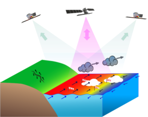
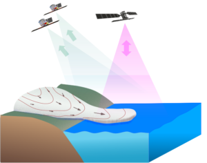
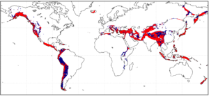
The Harmony mission is dedicated to the observation and quantification of small-scale motion and deformation fields at the air-sea interface (winds, waves, surface currents), of solid Earth (tectonic strain and height changes at volcanoes), and in the cryosphere (glacier flows and height changes). In order to achieve the different mission goals, the Harmony mission shall deploy two companion satellites following one of ESA’s Copernicus Sentinel-1 satellites. The companions will be flying in two different formations (see Figure 1): the stereo formation, with one Harmony satellite placed in front and one behind Sentinel-1, in both cases at a distance of about 350 km from it; and the cross-track formation, with both Harmony units flying close to each other (~200-500 m) also at 350 km from Sentinel-1. Each Harmony satellite carries as main payload a receive-only synthetic aperture radar (SAR), which shall acquire the reflected signals transmitted by Sentinel-1 towards the Earth. A multi-view thermal infra-red payload is also included to measure cloud height and cloud motion vectors. The angular diversity provided by the Harmonies in combination with Sentinel-1 will allow the retrieval of deformation measurements of the sea and earth surface with unprecedented accuracy (see Figure 2), while the cross-track configuration will allow the accurate measurement of elevation changes for land-ice and volcanic applications.
Figure 1: Representation of the (left) stereo and (right) cross-track flying formations for Harmony. The Sentinel-1 satellite is depicted in black color. Sentinel-1 transmits a signal and acquires the backscattered echoes (represented with magenta arrows), while the Harmony satellites receive part of the energy that bounces towards them (represented with the green arrows). Copyright: Harmony Mission Advisory Group.
Dr. Paco López-Dekker from the Delft University of Technology and principal investigator of the Harmony mission, comments “It is very exciting that our multi static-SAR concept, which combines many ideas that were matured during my years at HR, has made it to this final stage. During Phase-0 we have drafted a beautiful and elegant mission concept promising an unprecedented view at Earth System processes. Now we have the responsibility to look at it from all sides and be sure that it will work. Challenging and fun.”
Professor Juliet Biggs from the University of Bristol and member of Harmony’s Mission Advisory Group at ESA adds “The Harmony mission is remarkable in that it promises new scientific discoveries across an astonishing breadth of topics: from the gradual motion of tectonic plates to small-scale processes on the ocean surface. I’m delighted that we have been selected to develop the concept further and that Harmony is one step closer to becoming a reality”
Dr. Pau Prats, from the German Aerospace Centre, DLR and member of Harmony’s Mission Advisory Group at ESA, is convinced of the benefits a mission like Harmony will bring to the community: “The unique configuration of the Harmony satellites in combination with Sentinel-1 will allow us to literally add a new dimension to SAR observations, a fact that will foster SAR technology and its applications during the next two decades.”
Figure 2: Coloured areas show regions straining at greater than 10 nanostrain per year (the threshold above which 95% of earthquake fatalities occur). Blue regions are those that have a small component of north-south strain and can be imaged by Sentinel-1 alone. Red regions indicate the extra area that will be constrained by Harmony. From Harmony Report for Assessment. 2020.
So, what’s next? Even though Harmony is currently the only EE-10 mission candidate it does not mean it will be implemented. The industry and science teams have one and a half years of hard work ahead to demonstrate the mission has reached the technological and scientific level of maturity required to enter into the next phase, that will ultimately result in the launch of the Harmony satellites by the end of this decade.
Announcement can be found on ESA website: https://www.esa.int/Applications/Observing_the_Earth/ESA_moves_forward_with_Harmony
Title figure for the Harmony mission. Copyright: ESA.


