Tag Archives: InSAR

Nepal earthquake

COMET scientists have been closely involved with international efforts to analyse satellite data from the recent Nepal earthquake.

Combining two Sentinel-1A radar scans from 17 and 29 April 2015, this interferogram shows changes on the ground that occurred during the 25 April earthquake that struck Nepal. An overall area of 120x100 km has moved – half of that uplifted and the other half, north of Kathmandu subsided. Vertical accuracy is a few cm. Credit: Copernicus data (2015)/ESA/Norut/PPO.labs/COMET–ESA SEOM INSARAP study
Combining two Sentinel-1A radar scans from 17 and 29 April 2015, this interferogram shows changes on the ground that occurred during the 25 April earthquake that struck Nepal. An overall area of 120×100 km has moved – half of that uplifted and the other half, north of Kathmandu subsided. Vertical accuracy is a few cm. Credit: Copernicus data (2015)/ESA/Norut/PPO.labs/COMET–ESA SEOM INSARAP study

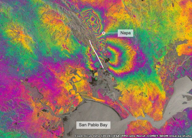
You can read more about the Sentinel-1A interferogram on the ESA website.

Links to some of the broader media coverage of our work can be found below.

BBC World Service Science Hour 02.05.15

Listen to Tim Wright describing images of the Nepal earthquake from Sentinel-1A satellite

BBC website 01.05.15

James Jackson, Philip England and Richard Walters are quoted in this article explaining why the Nepal earthquake was so deadly

BBC website 29.04.15

Tim Wright describes the Sentinel-1A interferogram of the area affected by the Nepal earthquake

EOS 27.04.15

James Jackson explains the risks associated with the Nepal earthquake

COMET scientists analyse Calbuco eruption

On 22nd April Calbuco volcano, Chile, erupted for the first time since 1972 with very little warning. Plumes of volcanic ash reached heights of 16 km on the 22nd and up to 17 km in a second, longer eruption that began in the early hours of 23rd April.

Several thousand people were evacuated from villages closest to Calbuco , and ash fell over an area extending from the west coast of Chile to the east coast of Argentina, and grounded air traffic in Chile, Uruguay and Argentina.

COMET scientists have been using satellite data to analyse the event, in terms of both the emissions and changes to the shape of the volcano itself.  You can read more about the event here.

Figure 4. Data, spherical source elastic half space model and residuals for recent deformation at Calbuco [Bagnardi].
Data, spherical source elastic half space model and residuals for recent deformation at Calbuco [Bagnardi].


Earthquake monitoring gets boost from new satellite

Europe’s Sentinel-1A spacecraft and its extraordinary images of slip from the South Napa earthquake herald a new era of space-based surveillance of faults.

JE Napa

On 24 August 2014, the San Francisco Bay area shook in an Mw = 6.0 earthquake, the region’s largest in 25 years. The tremors injured roughly 200 people, killed 1 person, and damaged buildings near the quake’s epicenter in the southern reaches of California’s Napa Valley. It also set off a scientific scramble to measure the fault’s movement and marked the dawn of a new age of earthquake satellite monitoring thanks to a recently launched spacecraft: the European Space Agency’s Sentinel-1A satellite.

COMET scientists explain why in an article published in EOS, the Earth and space science journal of the American Geophysical Union.

You can read more here, and download the PDF here.